Autumn is the most beautiful time of year to enjoy the Canadian Rockies. Unfortunately, 2018 saw smoky summer transition directly to white winter with several early season dumps of snow including a record-smashing event (#Snowtober) which effectively brought the scrambling season to an unceremonious end. Being a “glass is half-full” kind of outdoorsman, however, I decided to take the meteorological lemons we’d been dealt and to fashion something resembling a tasty beverage from them. As a late October weather window finally manifested, I arranged for a day off work, grabbed my snowshoes and headed for Gibbon Pass Peak!
When Matt Clay brought larch-laden Gibbon Pass Peak to my attention several years ago, I’d always thought it would make for a nice winter outing. When I asked Matt for his thoughts, he suggested that it might go on snowshoes but that I’d be stupid to do it any time other than larch season. Luckily for me, 2018 brought snowshoe season to the Rockies before larch season had even ended!
While I knew that Gibbon Pass Peak would be spectacular on a clear October day, I also knew that it was a long outing. Matt Clay’s route via Arnica and Twin Lakes involved nearly 25 km distance and 1,600 m cumulative elevation gain. Up against short October daylight hours, I therefore decided to approach via the direct Twin Lakes route which involved less total elevation gain (1,250 m) over a similar distance. Unable to leave Calgary until 7:30 am (my daughters’ daycare drop-off time), I hoped that my route’s smaller elevation gain might allow me to complete it before sunset (6:40 pm) …
Arriving at the Twin Lakes trailhead, I found that the valley bottom was icier than it was snowy and opted to leave my heavy snowshoes behind. I reasoned that their added weight would probably slow me down more on the 11 km hike to Gibbon Pass than they would speed me up above that. My ever-faithful climbing partner Crux was also with me, and since snowshoes don’t fit him, I figured we could posthole together up high if it came to that!
.jpg)
The well-marked trail to Twin Lakes begins with a bridged crossing of icy Altrude Creek. Having hiked along a number of nearby trails (Bourgeau Lake, Redearth Creek, Boom Lake, Taylor Lake etc.), I anticipated a rather dull plod in the forest to start the day and found that my expectations were, disappointingly, met! After crossing the creek meters from the parking lot, I felt no need to reach for my camera for the next 2 hours. The trail to Twin Lakes really is a special kind of awful!
.jpg)
About 6.5 km from the parking lot, I spotted a cool-looking stump. Having been deprived of anything remotely interesting for 2 hours, I (for some reason) felt compelled to photograph it.
.jpg)
Shortly after the excitement that the stump incited ebbed, the trail meandered towards Lower Twin Lake’s outlet stream and Crux and I were finally treated to a half-decent view.
.jpg)
Storm Mountain suddenly appears as the forest abates. As I hiked through this beautiful alpine meadow, I thought to myself: “This hike is finally starting to become enjoyable!” Seconds later, I sank knee-deep into a mud pit. This was no meadow…it was a bog. :-(
.jpg)
A little over 8 km from the trailhead, I finally reached Lower Twin Lake (which, it should be noted, requires a small detour off the Gibbon Pass trail to reach). The lake is adequate but, for the effort involved, not worth it as a destination on its own in my opinion. If you want to hike to a pretty mountain lake, Banff National Park is replete with better options!
After briefly visiting the lake, I resumed my hike towards Gibbon Pass. Having somewhat enjoyed the more open vistas that the lake and bog afforded, I was disappointed to discover that most of the remaining 3 km hike to Gibbon Pass took place in (another) viewless forest. The camera was once again stowed away.
.jpg)
After another hour sans scenery, the forest flora began a slow shift from evergreen to golden larch suggesting that the long hike to this point might soon pay off!
.jpg)
Four hours (and 11 km) after setting out at the trailhead, I finally reached glorious Gibbon Pass. I'm not sure that I'd be keen to repeat this, otherwise, painfully dull hike but the pass was as spectacular as advertised!
.jpg)
Two massive outliers of Storm Mountain tower above the pass' larch trees, remarkably still aflame in their autumn ambers despite it being late October! To the far right, Storm Mountain's true summit is distant but equally impressive. Click to see larger.
.jpg)
A closer look at Storm Mountain's outlying peaks. It's hard to imagine that peaks this big and beautiful are unnamed!
.jpg)
Looking north towards Gibbon Pass Peak some 300 or so meters above. Exhausted from the morning's undertakings, I sat down to enjoy a brief lunch at 2:00 pm. Unfortunately, I had to eat FAST since I needed to be home by 10:00 pm to watch my girls while my wife went to work for the night. Some quick mental arithmetic suggested that I'd have to turn around by 3:00 pm if I was going to get home in time. Noting that there was a significant amount of snow on the ground and no trail broken up to the peak, I wondered if my decision to leave the snowshoes in the car would come back to bite me. Only one way to find out ... I finished my sandwich as quickly as possible and started to HAUL ASS hoping to make it up the peak in time!
I backtracked a little from the Pass and started up along the obvious band of larches which rise from bottom left to upper right in the photo above. As the larch forest thinned, I aimed directly up steep snow slopes towards the summit. I should note for the benefit of anyone else who wishes to attempt Gibbon Pass Peak in winter conditions that the safest route likely gains the ridge much further to the left (west) of the peak and then follows the more gentle ridge up, avoiding steep slopes that could slide. Given the constraints on my time, however, this route would have proven too lengthy. As it was, I was reasonably certain that my more direct route would take longer than the hour that I had left to complete the ascent!
.jpg)
The terrain steepened dramatically as the larch forest thinned and I was, initially, somewhat hesitant to ascend. Proceeding cautiously, I was pleased to discover that the snow on this slope felt relatively stable and, so, continued upwards.
.jpg)
After rapidly ascending the steepest section, Crux and I paused to catch our breath. Hoping to make it to the summit before our 3:00 pm turnaround time, our pace from the pass had been extreme and it now felt as though my heart might beat right out of my chest!
.jpg)
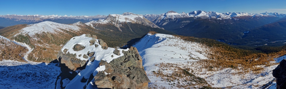
While continuing to HAUL ASS up open slopes towards the summit, a magnificent panorama unfolded at our backs (providing a welcome excuse for occasional photo stops/much-needed breathers). Again, if you choose to ascend Gibbon Pass Peak in winter conditions, be cognizant of snow stability; these slopes are steep enough to slide. On this day, I felt confident enough to proceed as recent warm weather had created a consolidated layer of snow that allowed for easy step-kicking. Click to see larger.
.jpg)
2:54 pm!!! An exhausted Crux enjoys a hard-earned rest atop Gibbon Pass Peak with 6 minutes to spare! Rather than rest, I of course grabbed my camera and finally allowed myself to revel in the spectacular fall/winter scenery!
.jpg)
From the summit, the panorama to the north is revealed for the first time. Stretching from Skoki (left) to Mount Assiniboine (right), the entire mountainscape was filled with golden larch forests and snow-capped peaks! Click to see larger.
.jpg)
The peak's north face featured an impressive drop off including an unbroken near-vertical slab. This photo doesn't really do it justice but, suffice to say, you'll want to mind your step up here.
.jpg)
Skoki giants Mount Richardson, Pika Peak and Ptarmigan Peak rise up above Lipalian Mountain and Redoubt Mountain some 35 km to the north.
.jpg)
The sheer south faces of Protection Mountain and Castle Mountain form an impressive buttress beyond larch-laden hillsides and across the Bow Valley.
.jpg)
A host of remote, snowy peaks rise up beyond Castle Mountain's readily recognizable ramparts.
.jpg)
Noetic Peak (right) and its outliers (center) probably don't see many visitors.
.jpg)
Mystic Mountain (left) and Mount Ishbel (center) are visible beyond Copper Mountain's shoulder.
.jpg)
Nearby Copper Mountain (left), Pilot Mountain (center right) and Mount Brett are popular Kane scrambles. Shockingly, I've not attempted any of them yet.
.jpg)
The Sawback Range makes an appearance down the Redearth Creek Valley. Further still, Banff landmark Cascade Mountain (center) towers above the other visible peaks.
.jpg)
A closer look at Pilot Mountain (left) and Mount Brett (right).
.jpg)
Enjoying some summit sun with my bestie. After the fall that we've had, who would have guessed that I'd be atop a peak in a t-shirt on October 22?!
.jpg)
WOW. A magnificent mixed winter/autumn scene stretches from the Sunshine meadows (left) towards behemoth Mount Ball (right). Click to see larger.
.jpg)
Majestic Mount Assiniboine (center) and the Monarch (right) rise up beyond larch-rich Healy Pass Peak (foreground left) and the diminutive-looking Monarch Ramparts (foreground right).
.jpg)
The mind-melting view south towards Banff National Park's Egypt Lakes area. While views like this make almost any amount of suffering on approach worth it, it's also worth remembering that 22 km of this 25 km day are miserable hiking through viewless forest. Still, I must admit that the long, boring return trip was far from my mind as I soaked in the spectacular summit sun and scenery!
.jpg)
Greater (center left) and Lesser (center right) Pharaoh Peaks in the heart of the Egypt Lakes area.
.jpg)
Spectacular Shadow Lake begins to ice over as winter draws nearer.
.jpg)
The many towers of Kootenay National Park's Mount White Tail (right) stand tall beyond Haiduk Peak (left).
.jpg)
Behemoth Mount Ball rises over 4,800 feet above Shadow Lake. Although it's been 5 years since I stood atop Mount Ball, that ascent remains one of my most memorable to-date!
.jpg)
The best of both worlds: the Ball Range clad in wondrous winter white while Gibbon Pass' carpet of larch trees remain aflame in autumn amber. Talk about making lemonade out of the meteorological lemons that 2018 dealt to southern Alberta! Click to see larger.
.jpg)
Storm Mountain casts a long October shadow over Lower Twin Lake while golden larch trees continue to glow in the afternoon sun. As I enjoyed the summit scenery, I noted that Storm Mountain's shadow was growing ever longer...
.jpg)
11,000ers Temple and Hector bookend the Bow Valley to the northwest (Mountain Boy).
.jpg)
Massive Mount Temple towers above Mount Bell.
.jpg)
A host of Icefields Parkway peaks (including from left to right: Crowfoot Mountain, Bow Crow Peak, Bow Peak, Observation Peak, Cirque Peak and Dolomite Peak) stretch north beyond Mount Hector.
.jpg)
With the afternoon shadows growing ever longer (and our 3:00 pm turnaround time long past), my best climbing partner and I posed for a final summit photo together before starting the LONG hike down.
.jpg)
Back amidst Gibbon Pass' spectacular larch forests following a glorious glissade! The slope that took Crux and I nearly an hour to ascend took only a quarter of that time to descend thanks to a "cheeky" bum slide!
.jpg)
Sometimes it's easier than others to retrace your steps (♫ follow the yellow postholes ♫)!
.jpg)
Crux accessorizes with a hair piece. I think he looks he looks quite fetching as a blonde. Sadly from this point onwards, we left the magnificent views behind and started the LONG, one-foot-in-front-of-the-other 11 km hike down through the woods.
.jpg)
The sun casts its last golden rays upon Castle Mountain as we continue the painful plod downwards. In addition to being long, the Twin Lakes trail has an annoying habit of side-hilling instead of losing elevation. It’s also replete with roots and rocks to remind those who hike down on auto-pilot that paying attention is still a good idea! These obstacles, of course, become more daunting once the sun sets (which it did while Crux and I were still several kilometers from the bottom) … It’s a good thing that the views up top made every painful step worthwhile!
.jpg)
Remember all that talk about fashioning a tasty beverage from meteorological lemons? Well it wasn’t just talk! Once we’d successfully closed the book on our fabulous fall/winter ascent of Gibbon Pass Peak, we celebrated with a most appropriate ale! That (pint) glass, however, didn’t stay half-full for long! ;-)
.jpg)
.jpg)
.jpg)
.jpg)
.jpg)