Cox Hill Attempt
Elevation: 2219 m
Elevation Gain: 630 m (to turnaround point - 120 m more for summit)
Cox Hill was originally named Cockscomb Hill for a cockscomb-like fringe of rocks near its summit. The hill was named by the veritable Arthur O. Wheeler who also made the hill's first (recorded) ascent in 1895. Over time, the name shortened and Cox Hill is now in common use.
My Attempts:
May 19 2018
Trailhead: Dawson Trailhead
GPS Track: Cox Hill Attempt (to slope below false summit)
With work-related travel shrinking my May long weekend from 3 days to 1, I convinced my wife, kids and parents to spend our 1 day together as a family in the mountains. Cox Hill has been on my family to-do list for some time owing to its well-established trail and relative proximity to Calgary. I'd always been a little concerned, however, that it might be just a little too long and a little too high to realistically complete with the kids. Hoping that my wife would talk me out of it, I, therefore, fully disclosed the round trip distance (about 13 km) and elevation gain (750 m) to her the night prior. I was somewhat stunned when she simply said "Sounds good!" As I'd later discover, she wasn't listening...
.jpg)
Looking towards Moose Mountain (left) and Cox Hill (right) from near the junction of Highway 68 and Powderface Trail. As you can see from the photo, Cox Hill is mostly forested meaning that views are few and far between until you get higher.
.jpg)
Grandma escorts Mera across an impressive bridge which appears to have been built quite high after flooding wiped out its predecessor in 2013. The parking area is large, however, the trailhead isn't incredibly well-marked. For those who have minor issues finding it, it's essentially just downstream of the parking lot.
.jpg)
Thanks to a still-massive winter snowpack, Jumpingpound Creek looked less like a creek and more like a raging torrent.
.jpg)
Grandpa shows Mera who's "fastest."
.jpg)
A small opening provides one of the trail's few early views. By this point, we'd walked 1.5 km and seen little but forest.
.jpg)
Glimpses of our objective through the woods proved slightly discouraging - both as a result of its distance from us and its snowiness. Ultimately, the latter would end up thwarting our attempt to bag this little peak.
.jpg)
Enjoying a family picnic about half way up. Brianne, Crux and I enjoyed PB & J while Mera enjoyed PB, J & Dirt.
.jpg)
"C'mon Grandma - let's go!" On the road again...
.jpg)
Forest views aside, Penny and Brianne seemed generally pleased to be out in the fresh air and sun.
.jpg)
Grandpa stops for a brief view from a clearing.
.jpg)
Said view.
.jpg)
Telephoto towards Calgary from Grandpa's viewpoint.
.jpg)
Hmmm...this isn't what most of our group signed up for. As the snow grew deeper, the girls grew less committed to reaching the summit. Indeed, Grandma opted to remain behind on dry ground while the rest of us pressed forward to see if we could, at least, get a view towards the actual mountains!
.jpg)
Grandpa did pretty well on all that snow (especially for a guy who had a hip replacement just under a year ago)! Fortunately, his perseverance paid off and we reached an open area with nice views to the west about 6 km from the trailhead.
.jpg)
A steep switchback ascends Cox Hill's false summit. Throughout the morning, several other parties warned us that this section was treacherously slippery in places and waist-deep post-holing in others. Not wanting to push our luck or to leave Grandma behind for too long, we opted to enjoy the view from this open area for a couple minutes before returning.
.jpg)
Crux and I take in the view of the Rockies' eastern edge including (from left to right): Mount Townsend, Morrowmount, Yamnuska (foreground), Saddle Peak, Mount Costigan, Association Peak, End Mountain, Orient Point and Black Rock Mountain.
.jpg)
Having had enough post-holing already, Brianne and Penny opted to enjoy the view from closer to the trees.
.jpg)
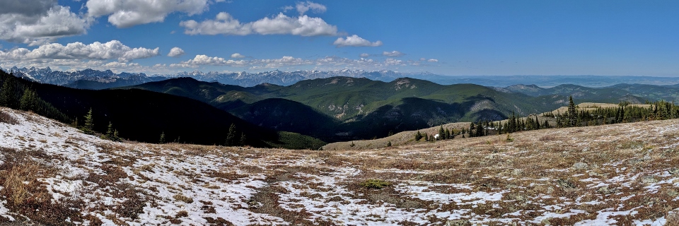
It might not be a "summit" panorama but the view from our stopping point was no less beautiful as the Front Ranges jut skyward beyond nearby Lusk Ridge. Click to see larger.
.jpg)
Daddy-Daughter selfie. I even managed to get Mera to look at the camera and smile (although an "offering" of chocolate may have been made to achieve that feat).
.jpg)
Mount Sparrowhawk, Wind Mountain and the remaining 3 peaks of Mount Lougheed tower above Midnight Peak and Mount Collembola on the left. To the right, Mount Lorette and Skogan Peak rise above Mount Baldy's West and South Summits.
.jpg)
Mount Rundle (distant), Grotto Mountain, Gap Peak, Mount Charles Stewart and Mount Fable highlight the view to the northwest.
.jpg)
Forested foothills and flatlands as far as they eye can see to the north.
.jpg)
Beautiful smiles from all my girls (again, likely related to chocolate bribery).
.jpg)
Even the "Baby Bear" wanted chocolate. Alas, not until she has a few more teeth!
.jpg)
Grandpa and I enjoying our biggest hike together in a long time (while Mera enjoys another M&M).
.jpg)
Carefully descending the slick, snowy trail with my training weight.
.jpg)
A short time after we started back down, we were reunited with Grandma (but not before she called my cell phone to make sure we hadn't perished).
.jpg)
Fortunately, Grandma had at least been left with a lovely view of the prairies and nearby Moose Mountain. Click to see larger.
.jpg)
A closer look at Moose Mountain.
.jpg)
Spring has sprung (down low anyways)! A lonely crocus provides hope that the snow higher up will not last much longer.
.jpg)
Learning the hard way...turns out that my concerns about the day's length and elevation gain proved well-founded! As we continued down the trail, we found that it was duller on descent than it had been on the way up (isn't it always?). We also found out that our children are pretty heavy as our feet, knees, backs and shoulders protested under their added weight.
As our discomfort grew, Brianne established new rules concerning appropriate distances and elevation gains for future trips. Fortunately for me, rules are meant to be broken! ;-)
.jpg)
.jpg)