Vimy Peak is one of those Canadian Rockies "postcard" mountains. Like Rundle and Cascade in Banff or Mounts Temple and Victoria in Lake Louise, when you think of Waterton, you picture Vimy's colorful cliffs towering above wind-whipped Waterton Lake. I remember the view of Vimy from my first boat tour across the lake as a young child. I can (luckily) remember it being the backdrop for stone-skipping contests with my uncle as a smart-ass preteen (his aim left something to be desired and he beamed me in the head with a rock "by accident" - I'm sure I deserved it). I remember camping with my then-girlfriend (now-wife) and seeing Vimy's silhouette lit up in the dark of the night by powerful thunderstorms. It's one of those peaks that's so beautiful to behold from below that you can't help but wonder what below looks like from above. For years I've wanted to see Waterton from Vimy (instead of vice versa). Luckily as a peak bagger, I find myself with the opportunity to sate that curiosity; so when Matt Clay reached out to see if there were any peaks that I'd like to bag together, I immediately suggested Vimy. Although the summit can be reached by a good hiking trail, that trail is sufficiently lengthy to discourage most. Fortunately, Matt C. shares my affinity for long days and high quality suffering so we agreed to leave Calgary at 5:40 am on a sunny June morning in 2017, 100 years after the events for which the peak was named.
.jpg)
Matt C. pauses to admire the view of Vimy (center right) from the grasslands of Waterton's "Wishbone" trail. If the peak looks distant, it's because it is! The "Wishbone" trail runs from the Chief Mountain Highway winter closure gate to Vimy's foot some 7 km distant. As one of the few Waterton trails that allows cycling, most of those who set out to hike Vimy start their journey on 2 wheels. We, however, decided to hike the entire 26 km round trip distance since neither Matt C. nor Crux were confident in their mountain biking skills.
.jpg)
By the time that we started our approach, it was already blisteringly hot and humid. The "Wishbone" trail gains no elevation whatsoever but we were still glad to find shade whenever groves of trembling aspens offered it!
.jpg)
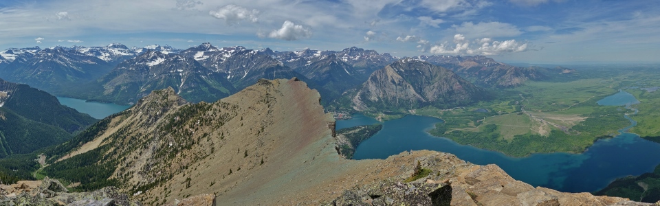
After enjoying a 5 km symphony from the many songbirds that call this area home, we reached the un-bridged Sofa Creek crossing. As we de-booted for the ford, we paused to take in the beautiful panorama of peaks from the prairie trail (click to see larger). For those looking for an easy hike away from the crowds in Waterton, I'd recommend following the "Wishbone" trail for its panoramic views and avian abundance.
.jpg)
Aptly named goldenasters abound near Sofa Creek as Vimy towers beyond. Despite the fact that we've already hiked 5 km, the peak still looks distant!
.jpg)
"Wishbone" wildflowers: goldenasters.
.jpg)
Matt C. and Crux tackle the surprisingly deep ford of Sofa Creek. We'd thought that we might be able to cross the creek without wetting our feet and were somewhat surprised to find knee-deep water here! With the hot June sun already taking a toll, however, it felt good to freeze our feet in the fast-flowing current!
.jpg)
While Sofa Creek's north bank was littered with yellow goldenasters, its south bank was home to a proliferation of violet artic lupines.
.jpg)
"Wishbone" wildflowers: mountain lady slipper orchid.
.jpg)
Wildrose country.
.jpg)
A large elk antler provides a welcome change-of-pace from the deluge of wildflowers along the "Wishbone" approach trail.
.jpg)
After completing the 6.8 km "Wishbone" trail, we reached its terminus at a signed junction. To the left, the trail continues up Vimy Peak while the right-hand branch follows Waterton Lake's east shore to Crypt Landing.
.jpg)
Beyond the junction, the trailside foliage became lush and dense. It might not look like it here but Crux is actually on-trail!
.jpg)
Some 7 km in and Vimy Peak still looks a long ways off. At least we're starting to gain elevation though! From here, a good trail ascends forested slopes to the left of Matt C. before climbing all the way back up to the peak on the right beyond the obvious ridge line ahead.
.jpg)
Crandell Mountain is reflected in the uncharacteristically calm waters of Middle Waterton Lake. This area is usually subject to gale-force winds but the air was atypically still on this morning.
.jpg)
Fresh prints suggest that we weren't the first to follow this trail today! My what big claws you have...
.jpg)
...and my what big poops you take (Crux's hindquarters shown for scale and because he decided to rest right next to this huge pile of bear $hit).
.jpg)
What am I to think when I round a switchback and see this? With so many signs of recent bear activity, is Matt C. practicing his "being attacked by a grizzly" pose? As I soon discovered, this unusual position was actually the result of attempted wildflower photography. No word on how this photo turned out...
.jpg)
Vimy Peak finally looks somewhat close in the horizontal respect (though discouragingly far from a vertical standpoint) as we approach a noisy cascade near a prominent outlier.
.jpg)
Craggy cliffs appear beyond lush foliage as we crest Vimy's northeast ridge.
.jpg)
Matt C. pauses to check out a scenic snow-bridged waterfall. After cresting the northeast ridge, the trail followed this noisy creek up its drainage, crossing it twice.
.jpg)
"Hmmm." I think there's a trail somewhere around here...it might be easier to find later on in the summer, however!
.jpg)
Eventually, the creek dwindled and disappeared beneath a snow-packed drainage. We followed this up, over mercifully supportive snow, until just below the cirque separating Vimy Peak to the west and Vimy Ridge to the east.
.jpg)
Spring crocuses poke through on snow-free south-facing aspects.
.jpg)
After leaving the snowy drainage, we meandered through arête-like snow features between tree wells before reaching Vimy's open east ascent slopes. FINALLY the peak looks close!
.jpg)
A snowy cirque separates the long and winding Vimy Ridge (left) from Vimy peak's sub-summit scree slopes (right). For those seeking to extend a hike that's already 26 km round trip, there are no shortage of options for scenic ridge walks that connect to other nearby peaks. In my opinion, however, the hike up Vimy is masochistic enough on its own!
.jpg)
Matt C. tackles steep loose scree just below the summit. If Vimy hasn't exhausted you by this point, this steep treadmill will soon do the trick!
.jpg)
Steep snow slopes drop abruptly towards the prairies near Vimy's summit. From here, the trailhead (located near a 3 way intersection above and right of obvious ponds) looks and IS a long ways back.
.jpg)
Crux does his best to look epic (while remaining on-leash) high above Upper Waterton Lake. From here, a 3 m wide ridge of blocky quartzite leads to the summit a short distance away.
.jpg)
After 13 km and 1100 vertical meters in the hot sun, I at last have my answer. THIS is what below looks like from above on the summit of Vimy Peak! Click to see larger.
.jpg)
A sea of snowy peaks rises above Upper Waterton Lake to the south. Many of these peaks sit across the 49th parallel in Montana's Glacier National Park.
.jpg)
A boat tour on Upper Waterton Lake - probably the same one that I first saw Vimy Peak from as a child so many years ago.
.jpg)
GNP peaks to the southwest. From left to right: snowy Mount Geduhn, Kootenai Peak, unnamed, Vulture Peak and Porcupine Peak.
.jpg)
"More impressive peaks to the south" - possibly The Guardhouse and Mount Carter.
.jpg)
More prominent GNP peaks (from left to right): Mount Chapman, Mount Peabody, Kintla Peak and Kinnerly Peak beyond their Canadian cousins Mount Richards (foreground center) and Mount Alderson (right).
.jpg)
Enjoying the summit panorama highlighted by Middle Waterton Lake (nearer) and Lower Waterton Lake (more distant). Click to see larger.
.jpg)
Looking beyond Vimy's western outlier towards the Waterton town site, bookended by Bertha Peak (far left) and Mount Crandell (right). At the trailhead, we had discussed exploring further west along Vimy's summit ridge towards this sub-summit to get a better view of Upper Waterton Lake. By the time that we finally reached the summit, however, we were significantly less-keen and opted to enjoy a well-earned rest instead!
.jpg)
Waterton and the Prince of Wales Hotel from high above.
.jpg)
Pointy Mount Lineham (left) and massive Mount Blakiston (right) highlight the western view towards the Akamina Parkway.
.jpg)
The scenic intersection of peaks and prairies.
.jpg)
Mount Glendowan (left) and Mount Dungarvon (right) form the western and eastern ends of the Red Rock Parkway to the northeast. Mount Galwey is the reddish peak in the foreground on the center right.
.jpg)
A remarkable topographic contrast to the north! My in-laws are somewhere down there enjoying "Happy Hour" at the Waterton Springs Campground.
.jpg)
According to the register, it is possible to connect the summit of Vimy Peak with that of "nearby" Sofa Mountain for anyone keen on completely numbing their feet.
.jpg)
An unusual summit perch! With no wind to speak of and hot, humid conditions, my poor black puppy sought refuge in an icy snow scoop.
.jpg)
Vimy Ridge winds towards a host of more easterly peaks. Although Vimy Peak is on the eastern edge of the Rockies, the panorama to its east is unusually spectacular. Click to see larger.
.jpg)
Distant Chief Mountain stands guard over the Canada/US border to the southeast.
.jpg)
To the south, Crypt Lake may still be frozen and snowbound but the massive waterfall escaping from it suggests that this will soon change.
.jpg)
A closer look at Crypt Falls. The hiking trail to snowbound Crypt Lake can be seen cutting across a scree slope on the far left. Where the trail disappears, it ascends a short ladder before passing through a 100 foot-long, natural tunnel to reach the lake.
.jpg)
American Mount Cleveland (left) towers above its more diminutive Canadian neighbor Mount Boswell (right) to the south.
.jpg)
A closer look at Mount Cleveland - one of the area's most recognizable peaks and the highest point in GNP.
.jpg)
The customary group summit photo. From left to right: Matt, Crux and Matt.
A final 3D summit panorama before starting the long trek back towards the "Wishbone" trailhead. Click and drag to explore Vimy Peak's scenic summit.
.jpg)
After enjoying a lengthy (but very hot) summit stay, we made good use of Vimy's steep scree slopes and plunge-stepped back towards the snowy ascent/descent drainage in no time flat.
.jpg)
Matt C. looks over the prairies from the snow-choked drainage. Like the loose scree above, the snow in this gully granted us a speedy (mostly posthole-free) descent.
.jpg)
Fresh claw marks on trailside trees. Although we didn't see any bears, it seems they weren't far off!
.jpg)
After a long and HOT descent, Crux enjoyed a well-earned recharge in frigid Sofa Creek. For a time, the poor pup's energy was clearly waning in the valley's heat. Fortunately, a 10 minute soak perked him right up; shortly hereafter, he was dragging my tired a$$ along the last 5 km of the "Wishbone" approach trail. As each step hurt a little more, it started to become obvious why most parties chose to cycle this approach... Photo courtesy Matt Clay.
.jpg)
The trail back may have been long but at least it was scenic! Waterton's close proximity of peaks and prairies is quite unique and this contrast in landscapes is nicely showcased along the "Wishbone" trail.
Despite the long day hiking under the hot June sun, every painful step was worth it. After years of wondering, I'm pleased to report that the view of below from above was every bit as spectacular as I'd hoped. Vimy Peak truly is a mountain befitting of its name.
.jpg)
.jpg)
.jpg)
.jpg)