Since the arrival of my second daughter Penny, I’ve generally been too tired to give a hoot about mountains. Family life is more rewarding (and at the same time more exhausting) anyways! As September ebbed, however, idyllic images of golden larch trees and alpine meadows crept back into my consciousness. Autumn in the Rockies is as colorful as it is short. Blink and you’ll miss it. I couldn’t miss it, could I? Recognizing the early signs of “larch fever”, my work and wife granted a prescription for the only cure to my ailment – an autumn alpine adventure!
With a responsibility-free day arranged to coincide with perfect fall weather, my mind raced. (Overly) ambitious plans were hatched. I ignored the fact that I was in “new dad” shape after a slower-than-usual scrambling season. I ignored the fact that I was legitimately ailing with a bad cold (turns out my fever wasn’t entirely larch-related).
“If I use a bike for approach, maybe I can explore some really remote areas – 35 km roundtrip isn’t that long…”
“I don’t get out that often. Why not make the most of it and bag a couple peaks? 2,000+ vertical meters is totally doable…”
Luckily, someone up there saw fit to spoil my grand plans and save me from myself. As I laced up my hiking boots, a snapped shoelace was the first omen. No matter, I’ll wear my mountaineering boots. As I grabbed my bike from the garage, the back tire inexplicably fell off. No matter, I’ll borrow my dad’s bike (I need to drop off a little one with my parents anyhow). As I tried to get said little one out the door, our exit was delayed by tantrums and toddlerisms. No matter, I’ve got a head lamp – who needs an alpine start? As I inspected my dad’s bike, I found its tires flat and the adaptor required to fill them missing. This proved to be the last straw. Obviously, my ambitious plans weren’t meant to be. Not wanting to waste the day, however, I came up with a more modest Plan B. Healy Pass Peak has been on my snowshoeing to-do list for ages but I figured that it would make a great larch hike as well. After a quick stop back home to grab Crux, I was finally able to start my drive to the mountains (during peak rush hour of course).
I’d like to say that I handled all of these curveballs with grace. I didn’t. Each made me angrier. As I arrived at the Healy Pass trailhead, things got worse. The Sunshine Village parking lot was very full. I’d been hoping to avoid the “larch madness” that’s overtaken Moraine Lake and other larch hotspots; I hike to escape crowds not be amongst them! Worse still, I noticed a Parks Canada restricted activity notice at the trailhead: summer off-trail travel has apparently been banned in the Sunshine Meadows area. Suspecting that Healy Pass Peak would require such travel, I threw my arms up in the air. Things just weren’t going my way!
Defeated, I decided to “just” hike to Healy Pass (still 18 km round trip) and started up the wide trail in a huff. After sweating and sulking my way up the first few kilometers, a funny thing happened. As I passed him, an older hiker smiled at me and told me to “Enjoy the grand day!” It was a simple statement but it turned my day around. Why was I upset? This gentleman was absolutely correct. The skies were clear and blue. The fall air was brisk and refreshing yet the sun’s kiss was warm. I was in my mountains; not at work; not stuck in traffic. This was a “grand” day! From that second on, I decided to treat it as such. Who would have guessed that it would end up among my best days in the mountains after such a trying start?
.jpg)
The trail to Healy Pass is as long as the introduction to this trip report and (in my mind) significantly less interesting! The path is rock hard and mostly in the woods. Still, occasional views of Healy Creek and the promise of grander views above help to make it tolerable (at least on the way up)!
.jpg)
Crux looking underwhelmed with the forest scenery on our way up the Healy Pass trail. It takes a couple hours for the trail to climb into the alpine but those who persist through viewless woods are amply rewarded.
.jpg)
A few slide paths on Mount Bourgeau’s south flank interrupt the forest on ascent. While this avalanche area wasn’t scenic enough to be noteworthy, I was rather impressed to find that snow from an avalanche last winter (the white in the middle of the gully) had persisted through the summer into late September. This slide path was south facing and well below tree line. That must have been ONE HELL OF AN AVALANCHE!
.jpg)
After 7.5 km without much to see, the scenery suddenly exploded as I neared the tree line.
.jpg)
Golden goodness to cure my “larch fever”.
.jpg)
Aurulent ambers adorn the alpine as the trail climbs gently towards Healy Pass. Sadly, the last 1.5 km to the pass passed all too quickly and I soon found myself at my final destination (or so I thought…).
.jpg)
From Healy Pass, the spectacular Sunshine Meadows stretch southward. Click to see larger.
.jpg)
Crux stops to enjoy a perfect fall day at Healy Pass. The pass really is a perfect place to just sit and immerse yourself in beauty.
.jpg)
An unnamed tarn highlights the view towards Mount Assiniboine (left) and the Monarch (right).
.jpg)
Even the bugs were decked out in full fall colors! I’d been expecting views of the Monarch from Healy Pass but finding a monarch there in late September was rather unexpected.
.jpg)
After cresting the pass, the trail continues west towards Redearth Creek and the Egypt Lakes. As you can see, the scenery to the north/west of the pass is as fine as that to its south/east!
.jpg)
Views west towards the Egypt Lakes from Healy Pass’ larch-laden meadows.
.jpg)
Healy Pass Peak to the north and a sign forbidding the usual access to it via unofficial trails up its gentle south ridge. The peak had been my goal but it seemed that a Parks area closure would thwart me…unless…
.jpg)
Although the views from Healy Pass were remarkable, I still really wanted to hike up Healy Pass Peak. What can I say? I’m a hopeless peak bagger. Hoping to find a legal way up it, I closely examined the “Restricted Access” sign that Parks Canada littered atop the pass. The area closure clearly extended north from the pass along the peak’s south ridge making the unofficial trail a “no-go.” My heart skipped a beat, however, when I noticed that the closure did not extend to the west of Healy Pass! Indeed, the Parks sign indicated no restrictions to accessing the peak via its western slopes (mouse over).
This was somewhat curious as the restriction was intended to protect sensitive off-trail alpine areas. Ironically, it appears that off-trail travel on the peak’s virgin west flank is legal while the established (but unofficial) trail up its south ridge is forbidden. All this is no doubt intended to deter casual wanderers and to keep the wild wild but, given the expanse that is the Sunshine Meadows, one has to wonder if it’s necessary. After the 9 km and 655 m gain required to reach Healy Pass, most hikers are probably content to eat lunch and turn around! Moreover, if the area is SO sensitive, why let a massive commercial operation (*cough* Sunshine Village) ferry hordes of tourists up to it year-round? Further, why promote it heavily on social media? Moreover, why encourage MASS visitation with free Park passes?...Sigh.
My frustrations with the double standard applied to commercialism and legitimate exploration of our Parks aside, I was fairly tickled to have found a “loophole” in the area closure that would allow for my legal access to Healy Pass Peak!
.jpg)
With the aim of giving the Parks closure a wide berth, I hiked down from Healy Pass for a full 200 m on the official trail to Egypt Lakes. From that point, the open west-facing slopes of Healy Pass Peak beckoned! On ascent, I bashed up a steep hillside to the climber’s left of an old rock slide. On descent, I found easier terrain a little further to the north. Fortunately, both routes stay well clear of the established trail on the “forbidden ridge”. Mouse over for lines.
.jpg)
After a steep grunt up alongside the old rock slide, the ascent angle eased and the summit came into view just above. Again, I tried to attack the summit from the climber’s left so as to respect the restricted south ridge (right).
.jpg)
My day featured some unexpected twists and turns but, ultimately, ended exactly like I hoped it would: atop a spectacular summit surrounded by brilliant fall colors!
.jpg)
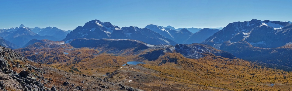
A soul-soothing summit panorama. After being so uptight for much of the morning, the summit of Healy Pass Peak was nothing short of cathartic! Click to enjoy larger.
.jpg)
Another larch-laden valley to the north below Pilot Mountain (right). The unnamed ridge to the left looks like a lovely place to wander off-piste.
.jpg)
A colorful larch carpet at the base of Mount Brett (left) and Black Brett (right).
.jpg)
Yellow larches and golden alpine meadows lead towards Harvey Pass and Mount Bourgeau (right). Bourgeau is flanked by snow-capped Mount Aylmer (distant left), Cascade Mountain (left) and Mount Peechee (right).
.jpg)
Sunshine Village (left) looks uncharacteristically snow-free but that will soon change! The ski area covers most of Eagle Mountain, Mount Howard Douglas and Wawa Ridge although the resort refers to the former as “Goat’s Eye Mountain” and “Lookout Mountain”, respectively. Further to the south (right), snow-capped Fatigue Mountain, Nasswald Peak and Golden Mountain tower above the Sunshine Meadows.
.jpg)
Crux enjoys the colorful scenery from his 75th different summit in the Canadian Rockies! Good boy!
.jpg)
A smattering of unnamed tarns and Eohippus Lake (most distant) dot the larch-filled meadows below the Monarch Ramparts and between bookends Mount Assiniboine (left) and the Monarch (right).
.jpg)
Looking southwest over Healy Pass (bottom) towards Mount Shanks (left) and Hawk Ridge (right). More distant summits like Split Peak (center left) and even Mount Nelson (right) can also be seen.
.jpg)
Larches for miles at the base of the Ball Range to the west! Click to see larger.
.jpg)
Somewhat remarkably, the large glaciated peak that rises above faintly visible Talc Lake (left) is unnamed! More distant Mounts Whitetail (center left) and Verendyre (center right) are both named but much less obvious from this vantage.
.jpg)
Bookended by the Sphinx (left) and Greater Pharaoh Peak (right), the Egypt Lakes make for a fine backdrop as Crux and I enjoy the grandest of days atop Healy Pass Peak!
.jpg)
A pair of paternoster lakes (Scarab Lake above/Egypt Lake below) and the imposing east face of Scarab Peak.
.jpg)
Isabelle Peak (distant left) and massive Mount Ball (right) tower above Lesser Pharaoh Peak (center left). Pharaoh Lake and Black Rock Lake can just be made out to the left and right of Lesser Pharaoh, respectively.
.jpg)
Mount Ball is breathtaking and its summit was hard-earned.
.jpg)
Storm Mountain soars skyward above Gibbon Pass’ larch-littered meadows.
.jpg)
Looking northwest beyond Gibbon Pass Peak (left) towards a multitude of mountains along the Icefields parkway. Snowy Observation Peak is visible in the distant center while Mount Hector is notable to the right.
.jpg)
A final look at some of the grandest summit scenery that Banff National Park has to offer before starting my descent of Healy Pass Peak’s wild west slopes. Click to see larger.
.jpg)
The Matterhorn of the Rockies highlights the view to the south from just below the summit. Note the burnt cluster of forest below the yellow larches on the far left of the photo: this appears to be where the mighty Verdant Wildfire bumped up against Twin Cairns very near Sunshine Village. Indeed, the entire Simpson River valley below this strand may be similarly scorched (though it’s hard to tell for certain given the harsh lighting this photo was taken under).
.jpg)
Thankfully the Verdant blaze never leapt the continental divide. If it had, these gorgeous anemones (western pasque flowers) and larches would likely be scorched earth.
.jpg)
Glorious hiking among the golden hued alpine bench west of and below Healy Pass Peak.
.jpg)
Healy Pass amidst a sea of gold. From here, I retraced my steps and regained the official trail 200 meters west of Healy Pass (and the off-trail restricted zone).
.jpg)
The downside of compliance with the Parks area closure was that I then had to regain elevation to get back up to Healy Pass! Even though I had much more ambitious plans to start the day, I was shocked by how exhausted I was as I started by descent! New dad shape and all, I suppose...
.jpg)
Upon returning to Healy Pass, I found it just as gorgeous and golden as when I left it earlier! The Monarch Ramparts and their long north-south ridge appear to have been another key point where the Verdant wildfire failed to jump the continental divide. I’m hoping to return to the Ramparts at some point in the next year or two to see just how far the fire advanced up their western (unseen here) slope!
.jpg)
It’s 2017 so a selfie is more or less obligatory.
.jpg)
A last look at the ‘Boine behind Simpson Ridge and Mount Strom before starting the long hike out.
.jpg)
As earlier, the kilometer and a half below Healy Pass flew by as I continued to revel in the brilliant fall scenery…
.jpg)
…the next 7.5 km, however, could only be described as Bourgeau-esque. The woods masked all. The trail was rock hard (an issue compounded by the stiff mountaineering boots I wore after tearing a lace on my hiking boots earlier). My body ached to the point of nausea (a combination of my cold rearing its head and exhaustion, I’m sure). You know it’s bad when the eyesore gondola station and parking lot at Sunshine’s base are welcome sights (if only as harbingers of the end)!
.jpg)
A blister where my little toe once was. Maybe I should have replaced the lace on my hiking boots instead of “playing through pain” in my more rigid mountaineering boots? Meh – hindsight is 20/20 and all. Beyond the blisters, words can’t really express how much the final 7.5 km down sucked. Thank God earlier events conspired to prevent me from attempting the 35 km, 2000+ m day I’d originally planned! This 22 km, 1000 m day had me limping around the house, sore and stiff for days after!
Still, having been gifted one of the grandest days I could have hoped for, I was (at least) limping with a smile on my face! Thanks to Healy Pass Peak, I’m happy to proclaim that my “larch fever” has been cured…at least until next September!!!
.jpg)
.jpg)
.jpg)
.jpg)
.jpg)
.jpg)