With All Hallows’ Eve upon us, I found myself in the mood for a spooky summit. After researching a few possibilities, Cornelius Rott’s “Ghost Peak” trip report caught my eye. In addition to its seasonally appropriate name, the peak also featured a relatively short approach (by Ghost/Waiparous standards) making an ascent feasible despite diminishing daylight hours. Located in an area of the Rockies which I’ve not often visited, I was keen to explore. Cornelius describes a difficult route up Ghost Peak but hints that easier options may exist. Armed with Cornelius’ trip report and beta from a more recent meetup group, Matt Clay and I set out from Calgary unaware of the tricks (challenging routefinding) and treats (an easy route with one moderate step) that Ghost Peak had in store for us!
.jpg)
After leaving Calgary in the pitch dark, we followed Cornelius’ access directions and arrived at the frosty trailhead just in time to catch the day’s first light. The open meadow parking area is located just south of a blue bridge over Fallen Timber Creek and marked by a “No Motorized Vehicles Past This Point” sign to the west. To get there: follow Highway 40 north from the Highway 1A junction. After 51 km, you’ll come to the well-signed Hunter Valley Road which you can follow west for 5 km. After 5 km, turn south onto a logging road and follow it for 3 km to reach the trailhead. As of late 2017, all roads were in good condition and, when dry, should be accessible with any vehicle.
.jpg)
After stalling in our warm SUV for a few minutes, we finally worked up the stones to brave the early morning cold and set off along a road behind the “No Vehicles Allowed” sign. Initially, this old road made travel easy but it soon dissipated into a series of tracks amidst boggy fields. Although the freezing temperature dampened our enthusiasm, the resulting frozen bog, at least, presented no challenges.
.jpg)
Fallen Timber Creek meanders through boggy surroundings as a still distant Ghost Peak looks otherworldly thanks to the day’s first golden rays.
.jpg)
Eerie mists dance atop Ghost Peak.
.jpg)
As we hiked west, the boggy meadows gave way to forest where an arrow-straight cutline facilitated our approach.
.jpg)
After a few kilometers, the cut line ended but a good trail continued on towards the pass immediately south of Ghost Peak. Although the pass is over 7 km from the parking area, this distance is not wasted as the cutline/path cover a good chunk of the day’s required elevation gain (500 vertical meters).
.jpg)
Matt C. pauses to check out Ghost Peak (right) as we arrive at the tree line. Without the forest’s shelter, the cold October wind quickly forced us to put jackets over our jackets. From here, we wandered over snowy meadows to the obvious pass. Click to see larger.
.jpg)
Looking out over Calgary (center horizon) from just below the pass. Mouse Over for a closer look at YYC.
.jpg)
A series of snow squalls ravage the area as we reach the pass. It was already cold when sunny so this meteorological development did little to improve morale. There are 4 – 5 separate squalls visible in this panorama alone. Click to see larger. Brrrr!
.jpg)
From below the pass, it looked as though Ghost Peak’s south ridge would provide a straightforward line of ascent. Above the pass, however, it became obvious that the shattered ridge was anything but straightforward. We had hoped to find easy scree slopes on the west side of the pass (left) but a large headwall/rock band guards this aspect nearly all the way to valley bottom. At this point, Matt C. openly questioned his ability/desire to ascend this kind of terrain; it looked as though Ghost Peak might prove more “trick” than “treat”!
If we’d paid close attention to the beta we were given, however, we’d know that the only hands-on scrambling required is up a moderate gully which breaks through the initial rock band. Above this gully, a wide, west-trending scree bench can be used to access easy scree slopes which lead to the summit above (mouse over for approximate route).
Unfortunately, we did not pay close attention to our beta and ended up following our noses up to and through the gap between the south ridge’s obvious ‘bunny ear’ pinnacles.
.jpg)
Matt C. ascends the moderate gully which cleaves the initial cliffs above the pass. Even covered in snow, this gully never felt more challenging than moderate (I’ve included some better photos of it later on from our descent).
.jpg)
Above the moderate gully, we got suckered into more moderate terrain. This terrain, of course, became increasingly difficult as we ascended. We should have followed the prominent, easy scree bench to the west but didn’t; the bench is pretty lengthy and its initial appearance offers no clue that it will eventually lead anywhere useful. At the base of the ‘bunny ears’, we found a mess of chockstones. I clambered up these to check out the route while Matt C. waited to hear my evaluation of the devilry above.
.jpg)
Ghost Peak’s biggest trick yet: from the top of the gap in the ‘bunny ears’, the easy scree ridge is only a 5 – 10 meters above. The problem being that a substantial walls blocks access to it! The wall looked do-able (though perhaps not advisable) so I investigated while Matt C. elected to call it a day, descend to easier terrain and wait for my return. The decision to separate was not taken lightly. In fact, I felt awful doing it. Matt C., however, assured me that I was not being an “asshole” by continuing my attempt without him. I’m not so sure but it ended up working out for the best this time.
As Matt C. descended, I explored. To the right, I found a wall with blocky holds whose vertical nature exceeded my comfort level. To the left, a slick slab led to overhanging rock. To the far left, another gully looked feasible but I couldn’t reach it as the result of terrain which dropped away alarmingly (this appears to be the gully that Cornelius and Priyesh ascended). After poking about for 15 minutes, I tried to ascend right up the middle. This was initially moderate but, as I climbed higher, the terrain proved steeper and more difficult than it had looked from below. Eventually, I reached a point where exposure and icy holds thwarted me (mouse over for lines). I was about 2 m from the easy ridge which leads the rest of the way to the summit. DAMN IT.
Defeated, I cautiously began to downclimb the tricky terrain I’d ascended when suddenly…a strange voice on the wind above! What specter beckoned on Ghost Peak?! With the wall above overhanging, I could see nothing…
From 2 m above, Matt C. casually yelled down with a half-chuckle: “Matt – I’m up.” Given that he was supposed to be waiting below and had been uncomfortable routefinding, this was most unexpected. Ghost Peak’s trick was about to become quite the Halloween treat! While I explored difficult terrain, Matt C., apparently, decided not to sit idly. He followed the scree bench and, although it appeared to lead nowhere for some time, found that it ultimately led to an easy scree slope (which he then ran up in the hopes of finding me). Feeling as though we’d snatched victory from the jaws of defeat, I quickly descended to the bench. We weren’t done with Ghost Peak yet!
.jpg)
Typical terrain along the scree bench. As I followed it west, I passed many gullies and breaks which looked like they might work. One could spend hours routefinding on Ghost Peak. Don’t – the easiest way up is well-hidden until you reach it. Then it’s DEAD obvious.
.jpg)
That’s right. I risked life and limb on icy, difficult terrain while Matt C. walked up this. Well, actually ran – but still! It is made up of the loosest, treadmill-est, worst-to-ascend scree ever and if you’ve poked around in difficult terrain for long enough, boy is it a treat!
.jpg)
Reunited, we continued up above the ‘bunny ears’ (center right) which had stymied me earlier.
.jpg)
Scenic slogging (photo courtesy Matt Clay).
.jpg)
Matt C. checks his GPS hoping that the high point ahead is not a false summit. Of course, it was.
.jpg)
Passing by an unexpected chasm. Although the peak’s upper west aspect appears to be open scree, there are several random pits which descend down to oblivion. If you attempt Ghost Peak in winter conditions, I’d advise caution as it’s easy to imagine these becoming bridged by snow.
.jpg)
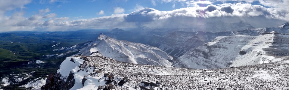
Matt C. enjoys the panorama to the south as we continue to ascend (click to see larger). Regrettably, the mountain silence was shattered at this time as a group of dirt bikers (literally) tore up the pass below.
.jpg)
Douchebags on bikes below. Ghost Peak and area are part of Don Getty Wildland Provincial Park and motorized access is illegal. I guess these fellows must have somehow missed the 6 foot wide “No Motorized Vehicles” sign below. Like most hikers, I’ll admit to being biased against dirt bikers and ATV users. Although my gut reaction is to abhor these noisy conveyances, the skeptic in me wonders “who or what are they hurting?” Stay tuned: our descent eventually revealed the sort of damage that disrespectful individuals can unleash on (supposedly) protected lands.
.jpg)
From the false summit, the south ridge to the true summit is initially ‘interesting’ before becoming a straightforward slog.
.jpg)
Matt C. cautiously makes his way along the ‘interesting’ down climb from the false summit. A few minutes later, we found ourselves approaching a hard-won summit!
.jpg)
Swirling mist and cloud ensured that Ghost Peak’s summit was appropriately spooky. As the summit disappeared among a veil of fog, shivers ran down my spine (it was damned cold after all). In the mist, I sensed a presence; we were NOT alone… (photo courtesy Matt Clay)
.jpg)
Ghost Peak’s resident summit specter! Not wishing to anger this astral projection, Matt C. and I sacrificed copious amounts of digital memory as we snapped summit photos to appease the spirit.
.jpg)
Appeasing the specter by sacrificing memory card space:
An impressive north face towering above a pocket of foothills. Click to see larger.
.jpg)
While our summit stay was mostly shrouded in cloud, occasional clearings (aka: sucker holes), revealed our scenic surroundings. Here you can see the abrupt manner in which the Front Ranges ‘kink’ to the west north of Ghost Peak. Peaks (briefly) visible include (from left to right): Mount Oliver, Puma Peak, Panther Mountain, Zombie Peak and a host of other unnamed summits. Click to see larger.
.jpg)
Looking north towards Ya Ha Tinda (hidden on the right) as the next squall approaches.
.jpg)
An impressive drop to the east. Click to see larger.
.jpg)
Is Matt C. participating in a bizarre summit séance (or possibly trying to not freeze to death in a ghostly gale)?
.jpg)
Atmospheric views of the many peaks to the south and west including (from left to right): “Sheep Meadow Mountain”, Black Rock Mountain, Orient Point, Castle Rock, Astral Peak, Mount Davidson, Apparition Mountain and Revenant Mountain. Click to see larger.
.jpg)
The 2 southerly summits of “Sheep Meadow Mountain” (left) and Black Rock Mountain (right).
.jpg)
Mount Costigan (distant center right) makes a brief appearance beyond the Devil’s Head.
.jpg)
Supernatural lighting over the Devil’s Head, Mount Costigan and Castle Rock.
.jpg)
A long east-trending ridge leads to “Waiparous Peak” and much larger Mount Davidson beyond. On a longer, warmer day, this could be a wonderful, easy ridge walk.
.jpg)
Although we’d snapped photos as quickly as our frozen fingers would allow, our sacrifice of memory card space failed to appease the summit specter! We were terror-struck as he called upon the surrounding spirits. The sky grew dark and the nearby mountains disappeared. As the gateway to the spirit world opened, we felt a fierce blast of cold air. It was time to get down lest our souls be trapped atop Ghost Peak for eternity…
.jpg)
Matt C. makes haste (and looks like he’s dressed to descend Everest not a Front Range Rockies peak) as we enter GTFD mode.
.jpg)
After an easy but blocky initial descent, we were pleased to take advantage of delightful scree to make up some of the time that we’d lost routefinding earlier.
.jpg)
Traversing back east across the key scree bench above the lower headwall.
.jpg)
Descending the moderate gully which will bring us back to easy hiking terrain (photo courtesy Matt Clay).
.jpg)
Matt C. working his way across a small traverse halfway down the gully.
.jpg)
Terra firma! Matt C. immediately below the moderate gully. The gully is actually 2 gullies – the obvious one above Matt C. was filled with chockstones and looked problematic. Out of sight to the right, however, is the easier gully pictured in the photo above.
.jpg)
Retreating to the pass as another snow squall envelops us.
.jpg)
Below tree line, we discovered the trail of destruction left behind by the boorish dirt bikes. To some, this may not look that bad but sensitive alpine terrain can take years to recover. Matters were certainly made worse by the fact that the ground was snow-covered and wet, allowing each biker to carve deep ruts as they needlessly joyrode all about.
.jpg)
The damage was not limited to the alpine unfortunately. Below tree line, there were many deep ruts where once a trail had been! Note the roots that these oafs cut through on the bottom right.
.jpg)
The cutline seemed straighter on descent (if that’s possible). While we’d barely noticed how long and straight it was on ascent, we certainly did as we tired on the way down.
.jpg)
Appreciating more open and scenic surroundings after the tedious cutline spat us out into the beautiful bog. A short time later, we found ourselves approaching the car and the salvation it offered in the form of heated seats! Glory be!!!
Complete with its many tricks and even the occasional treat, Ghost Peak proved to be a suitably spooky Halloween scramble. Having mastered the labyrinth that is its south ridge and survived our run-in with the summit specter, there’s only one way to appropriately conclude this trip report…
Ghostbusters Music Video HD from Vimeo.
.jpg)
.jpg)
.jpg)
.jpg)
.jpg)
.jpg)
.jpg)
.jpg)
.jpg)
.jpg)