Fullerton Loop
Elevation: 1600 m
Elevation Gain: 219 m
Round Trip Distance: 6.8 km
Fullerton Loop is a popular hike near Bragg Creek, AB. The east half of the loop visits a hilly valley while its west end follows an open grassy ridge. The ridge features pleasant views of front range peaks including Mount Fullerton. Like its nearby namesake mountain, Fullerton Loop was named for local rancher Jake Fullerton.
My Ascents:
May 6 2017.
Trailhead: Ranger Creek Parking
Saturday May 6, 2017 dawned in an unusual way. The sun rose and the temperature was warm. There was no snow. There was no driving rain. There was no thick fog. We couldn't even see our breath outside! In what's become a rarity during "spring" 2017, it actually looked like it might be a nice day! Seeking to take advantage of these unusual circumstances, we decided to head west for a family hike in the Kananaskis foothills. We set out from Calgary, with no particular hike in mind, and drove towards where Allen Bill Pond used to be. I knew that this area featured a large network of trails and figured that we could find something suitable for 18 month old Mera to enjoy alongside myself, her Mom and her "brother" (Crux).
.jpg)
From the parking area on the north side of Highway 66, we set Mera free from her child car seat. After consulting a trail map, she quickly selected "Fullerton Loop" as her hike of choice (mostly because she wanted to cross this bridge to get a better look at the "water!" near the trailhead).
.jpg)
Someone loves hiking now! Unlike last year, when she was constrained to a hiking backpack, Mera is now free to "Run!" and explore.
.jpg)
Checking out some rocks with her "tat".
.jpg)
A few hundred meters from the parking lot, the trail passes near the Elbow River and the wide swath of destruction that it caused during the 2013 floods.
.jpg)
First views towards the grassy hill which the west side of Fullterton Loop ascends. We opted to hike the loop in a clockwise direction since this would allow us to hike up this open slope with views west towards the mountains. If you hike the loop in the opposite (counter-clockwise) direction, your back will be to the mountains as you descend this section.
.jpg)
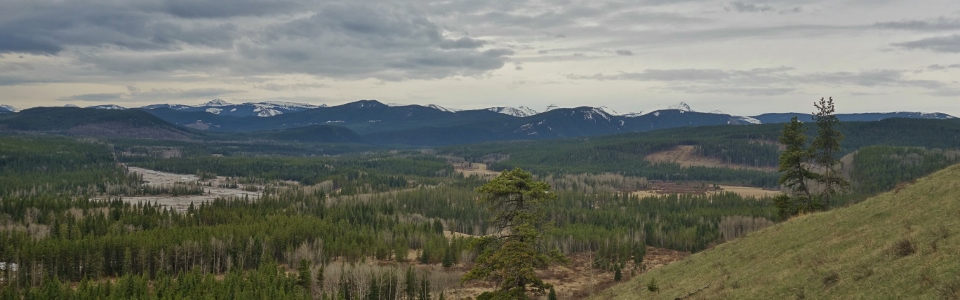
Snowy front range peaks begin to appear beyond forested foothills on the western horizon.
.jpg)
Happy hiking Hobbs'. After letting Mera walk the first km or so, we loaded her into the backpack to make up a little time; she loves to run...just not in a straight line!
.jpg)
The backpack experiment was, however, short lived. As the views around us improved, Mera was keen to hike up the hillside herself.
.jpg)
Holding Mommy's hand whenever a little help was required.
.jpg)
Checking out the view (highlighted by Banded Peak, Outlaw Peak, Mount Cornwall and Mount Glasgow in the center of the photo).
.jpg)
Playing "airplanes" with Mommy a couple hundred meters above the Elbow River floodplain.
.jpg)
Mount Fullerton makes an appearance near the hike's high point.
.jpg)
After hiking up 3/4 of the elevation gain on her own, someone needed a quick cat nap. We were, of course, happy to oblige and made good time as we descended the more forested east side of Fullerton Loop.
.jpg)
Icy channels cut by a stream near the end of the loop. The thickness of the ice at this elevation (1400 m) in May attests to how cold and gross "spring" 2017 has been!
.jpg)
Looks who's awake again. After a short nap, Mera was ready to run the rest of the way back to the trailhead. It would, after all, be a shame to sleep through such a pleasant (FINALLY!) spring day.