Coyote Hills
Elevation: 2149 m
Elevation Gain: 555 m (800 m cummulative gain)
The Coyote Hills are a series of high points near the intersection of Highways 541 and 940 west of Longview. Like nearby Raspberry Ridge, the highest of the Coyote Hills grants an impressive view of the High Rock Range to the west. The highest of these hills was named by A. O. Wheeler and R. W. Cautley of the Interprovincial Boundary Commission in 1916. Not surprisingly, the descendants of the coyotes for whom the peak was named still frequent these (and other nearby) hills today.
My Ascents:
February 24 2017.
Trailhead: Coyote Hills Parking (Roadside)
GPS Track: Coyote Hills
A heavily Can-con promoted band once pointed out that "the sun can't shine every day" while suggesting that we "have a good time" irrespective of the weather. With a Friday off work, Crux and I decided to heed their Juno award-winning advice and made our way west despite the promise of inclement weather. With sketchy avi conditions and low cloud forecast all over the Rockies, we set our sights on Coyote Hills. Having ascended nearby Raspberry Ridge a handful of times, I figured that I could at least imagine the summit view should my ascent end in a snowy whiteout as all the weather models predicted it would!
.jpg)
The cleared parking area 3.2 km south of Highway 540. After travelling through numerous squalls on the drive out, small patches of blue sky above the trailhead were an encouraging sign.
.jpg)
"The unsigned unofficial trail" that Nugara mentions in his snowshoeing guidebook. Despite its (presumably) recent erection, the sign isn't particularly helpful as neither of the indicated trails ascends the Coyote Hills. To make routefinding matters more interesting still, I only briefly glanced at the route description before leaving home. With the intent of loosely following Matt Clay's GPS track, it seemed like a waste of time to read guidebook directions. As I set forth, however, my GPS decided to install a software update which somehow consumed the GPS track I planned to use. Undeterred, I decided to "wing it"; my successful ascent of Coyote Hills can, therefore, be used as evidence that this trip is (more or less) idiot-proof.
.jpg)
Crux makes his way along the well-packed Baril Creek trail for 10 - 15 minutes. After the trail descended a small hill, we left it behind and followed an old 'shoe track down a steep embankment and across the creek.
.jpg)
Baril Creek - fortunately we were able to find a less fluid place to cross it!
.jpg)
Ascending the northern bank of Baril Creek and making our way towards the first of the Coyote Hills. From my limited route research, I recalled (incorrectly...) that the summit was atop a larger hill beyond the first. Obviously this day was going to be a cake-walk - I was already at the base of the first hill and it hardly looked like a hill at all!
.jpg)
Flagging tape here, flagging tape there, flagging tape (essentially) everywhere on the lower slopes of Coyote Hills. Sometimes it corresponded with a 'shoe track, sometimes not. Without a detailed grasp of the route, it was, nevertheless, encouraging!
.jpg)
Nearing the high point of the first hill, Crux and I spotted the second hill. So that must be it - the summit of Coyote Hills. Nothing to it. Piece of cake!...
.jpg)
After slogging up the second hill and thinking that we were approaching the summit, a MUCH larger hill appeared to the west. Maybe I should have read that route description a little more closely? Ah well - onwards and upwards! From here, Crux and I descended the 60 or so vertical meters ahead and then SLOGGED our way up the treed rib to the right of the large, potentially avalanche-prone clearing.
.jpg)
Crux pauses for a breather as we ascend the highest of the Coyote Hills (the second hill from which the previous photo was taken is now obvious below us). As the snow grew deeper near the top of the treed rib, it also grew looser and we found ourselves trending towards the more open slopes where wind-affected snow was easier to kick steps up. These open slopes present more potential for avalanches but, with no sign of instability and no solar heating, we followed the path of least resistance.
.jpg)
After a gut-busting ascent through progressively steeper and deeper snow, we were relieved to reach the ridge crest. With the hard work behind us, we looked forward to following the gentle south ridge up towards the summit.
.jpg)
Who knew that there were SO many ups and downs along this short ridge?! While the dips weren't significant vertically, they did create lots of lee areas which allowed the snow to pile up waist-deep. In some places, the snow was deep enough to bury Crux (and he's not a small dog!). Just keep postholing, just keep postholing...
.jpg)
At last! All the hard work pays off with a summit "view" (singular). This was, sadly, as good as the views got from the summit. Click to see the whiteout in more detail.
.jpg)
Mount Head (right) is sort of visible from the summit...for a few seconds anyways. While the views were distinctly lacking, I quite enjoyed my summit stay. Although very cold, the air was dead calm. With the highways below closed for winter, we were surrounded by perfect silence interrupted only by the faint sound of fat snowflakes falling on my shoulders. Crux laid down and I enjoyed a cup of hot tea. With no possible distraction, peace enveloped me like a warm bath (minus the warm part!).
.jpg)
My summit buddy.
.jpg)
Snapping a selfie amidst the falling snow before starting down.
.jpg)
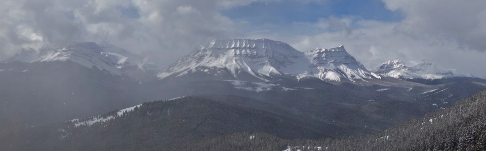
Proof that good things sometimes come to those who suffer up mountains in inclement weather. Despite the viewless summit, the clouds to the west began to clear as we made our way back down the summit ridge granting us a fleeting view of the nearby High Rock Range. Click to see larger.
.jpg)
From left to right: ephemeral views of Mount Armstrong, Mount Strachan and Mount Muir. Surprisingly, the obvious pointed summit in the center of the photo is an unnamed outlier of Mount Armstrong.
.jpg)
Here for a good time even if the views aren't here for a long time! After enjoying the sun's warmth briefly, the clouds returned and Crux and I plunged back down our broken trail towards the warm car below. Sun or not, I had a good time. I think that Trooper would be proud.
Trooper - Here for a good time by clydeascope
.jpg)
.jpg)