The most relevant conference for my industry was scheduled to take place in Las Vegas this year and, much to my chagrin, my employer insisted on sending me to “Sin City” to “network” (read: booze) for the entire 5 day event. Of course, no work-related conference would be complete without me playing hooky for a day to bag a peak (or 2!)…
.jpg)
After a busy boozy Sunday, Monday and Tuesday at the conference, Wednesday’s schedule looked fairly light to me so I rented a car and headed to nearby Red Rock Canyon National Conservation Area to escape the chaos that is the Las Vegas strip. As it turned out, finding the Bellagio car rental desk proved to be the crux of the day. After Google maps convinced me to climb a fence and explore a “casino employees only” entrance, security staff were happy to escort me to the correct spot. With my rental car finally arranged, I enjoyed a speedy 40 minute drive out of Vegas and into the wilderness!
.jpg)
They aren’t kidding when they say “red rock.”
.jpg)
Wildflowers add a splash of color to the already colorful bluffs.
.jpg)
Turtlehead Peak may be the most ascended mountain in Nevada thanks to its proximity to Las Vegas, non-technical nature and the fact that a marked trail takes you all the way up! Without much time to research an objective, I, therefore, opted for the popular option. After paying the $7 (US :-() entrance fee for the conservation area, I drove to the Sandstone Quarry trailhead and followed the little goat (!) signs towards my objective.
.jpg)
Turtlehead Peak (right) rises up beyond the sandstone block that never made it to market. They also aren’t kidding when they say “quarry.” With beautiful rock like this it’s not hard to see why this area used to be an active sandstone quarry.
.jpg)
The hike to Turtlehead Peak is brief and the unfamiliar but beautiful desert panoramas ensured that the small approach went by quickly. Click to see larger.
.jpg)
Desert critter! More accustomed to dealing with non-venomous bears, I was very much on the lookout for rattlesnakes and scorpions…
.jpg)
As Turtlehead Peak grew closer, the route up (which follows the gully on the climber’s left of the peak to a saddle before ascending the backside of the summit block) became obvious. Mouse over for approximate route line.
.jpg)
Dwarfed by an impressive desert flower!
.jpg)
As luck would have it, the desert was in full bloom on this day.
.jpg)
More flowers!
.jpg)
Despite reports of routefinding “issues” from friends who had previously climbed the peak, the path seemed fairly obvious to me (my friends must not have noticed the green paint “splotches” marking the route – then again their routefinding skills have been called into question previously…). ;-)
.jpg)
Much better than being stuck inside at the windowless conference!
.jpg)
The ever-improving panorama from the saddle. From here, the route swings around the gentle backside of Turtlehead Peak (left). To the right, El Padre Mountain and La Madre Mountain dominate the view…is it just me or do they look scramble-able?...Click to see larger.
.jpg)
Multiple trails weave their way up the mellow terrain on the backside of Turtlehead Peak. From this point on, it doesn’t really matter which trail you follow, just follow your nose and go up!
.jpg)
Las Vegas peaks out from behind the remnants of a twisted pine as the summit draws near.
.jpg)
On top and enjoying the sun (say, did I remember to bring sunscreen?)!
.jpg)
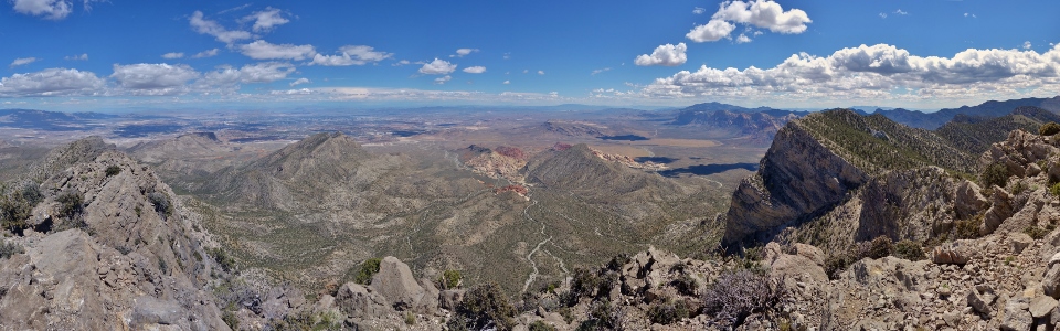
The Turtlehead Peak summit panorama is dominated by the colorful peaks of the Red Rock Canyon NCA (from left to right: Mount Wilson, Rainbow Peak, Rainbow Wall, Bridge Mountain, North Mountain and White Rock Hills). Click to see larger.
.jpg)
Bridge Mountain framed by the summit flora.
.jpg)
Colorful Calico Hills now lie far below. These sandstone bluffs looked quite large from the trailhead (on their far side). Click to see larger.
.jpg)
Las Vegas sprawls across the desert floor immediately to the east.
.jpg)
A telephoto reveals the larger casinos lining Las Vegas Boulevard. Beyond the strip, Lake Mead can faintly be seen filling the valleys between the peaks to the east of the city.
.jpg)
A broad wash winds along the flats separating Blue Diamond Hill (left) from the colorful Calico Hills as Postosi Mountain towers above all else on the southern horizon.
.jpg)
The much taller Spring Mountains rise up beyond the La Madre Mountains to the northwest. Click to see larger.
.jpg)
Is that snow in the desert?! Despite the high on 32C in Vegas on this day, snow was still obvious at higher elevations atop Griffith Peak (3,377 m) in the Spring Mountains.
.jpg)
While the views from Turtlehead Peak were awesome, the trip to the summit only took me 1 hour and 20 minutes. With plenty of time still left in the day, I decided to see if it might be possible to scramble up nearby La Madre Mountain (it would be a shame not to try while in the area, right?). Fortunately, cell phone reception on Turtlehead Peak was perfect and I was able to consult Bob Spirko’s website. While Bob’s website was a little mum on route details, it did mention that La Madre Mountain is the highest peak in Red Rock Canyon NCA. OK, now I had to climb it! Using Bob’s photos, I was able to piece together an off-trail route which took me all the way to the summit (thanks Bob!). The route involved bush cactus-whacking across the open desert north of Turtlehead Peak and scrambling up towards the El Padre Mountain (left) - La Madre Mountain (right) col. For anyone wishing to follow in my footsteps, be warned: there is no trail and the terrain is steep and loose for hikers. Capable scramblers will, however, have no problem negotiating the steep but non-technical class 2 terrain. Mouse over for approximate route.
.jpg)
The one thing that really sucked about my route was descending Turtlehead Peak’s north slopes and then having to regain all that elevation moments later! My entire descent was off-trail making the route feel wild and remote (until you glanced back at the nearby Las Vegas strip)!
.jpg)
What comes down (Turtlehead Peak) must go up (La Madre Mountain)! At the base of El Padre Mountain (left) and La Madre Mountain, I found an old rocky road which temporarily alleviated the toil of thrashing through spiny brush. Unfortunately, the road was short-lived…
.jpg)
A beautiful cactus in full bloom. Mouse over for a closer look at the flowers.
.jpg)
Looking back to Turtlehead Peak (center right) after re-gaining most of the elevation that I had to lose. Still a long way to go on La Madre Mountain though (over 500 vertical meters)!
.jpg)
The terrain steepens as I near the base of El Padre Mountain’s impressive limestone cliffs. From this point on, the route was rugged as I trended up and slightly to the climber’s right aiming for the col between El Padre and La Madre.
.jpg)
Despite the lack of trail, occasional cairns were welcome sights, suggesting that I might be on some sort of route!
.jpg)
Looking back down, what I felt was the crux, just below El Padre’s sheer cliff face. As you can see, the terrain here is quite steep. With good route-finding, however, only a few hands-on moves were required.
.jpg)
La Madre Mountain towers overhead in the sun while El Padre’s steep cliffs provide welcome shade! By this point, I knew that I would run out of water at some point on my way down (I had packed more than enough for Turtlehead but an extra liter would have been handy for my impromptu ascent of La Madre). Click to see larger.
.jpg)
Although the terrain leading to the col was complex, things could be kept simple (class 2) by staying as far to the climber’s left as possible (directly underneath El Padre Mountain’s cliffs). An added benefit to this route was the shade that the cliffs provided; in addition to not having quite enough water, I opted not to buy sunscreen after discovering that a small bottle was $30 US at the Bellagio’s gift shop (ripoff!). As my wife later pointed out, I easily could have bought some sunscreen at a gas station etc. on my drive out (where are all those helpful suggestions when I actually need them, Honey?). :-P
.jpg)
At the col (but out of the shade)! From here, the remainder of the route up La Madre Mountain is obvious.
.jpg)
Looking back towards slightly smaller El Padre Mountain from just beyond the col. El Padre Mountain can easily be ascended from the col as well, however, I opted not to climb it based on the red hue my exposed skin had taken on and the disturbingly light feel of my water supply by this point.
.jpg)
After hiking easily along the upper ridge, the summit of La Madre Mountain (and the spectacular view of Las Vegas below) finally came into view!
.jpg)
USGS confirmation that this is, indeed, the summit.
.jpg)
Summit selfie high above Calico Hills and Red Rock Canyon NCA. As you can see, I’d adopted a new mountain style (the MEC turban) to cope with the blazing hot sun by this point!
.jpg)
The 2,467 m high summit register. While the 2 register books on Turtlehead Peak were completely filled by entries from the past 5 months alone, La Madre’s register suggested that mine was only the 5th ascent of this mountain in 2016 (and the first ascent in the past 2 months). It seems most people are smart enough to call it a day back on Turtlehead Peak!
.jpg)
Despite the sunburn and dwindling water supply, the summit panorama east towards Las Vegas and Red Rock Canyon NCA is undeniably spectacular! Click to see larger.
.jpg)
Las Vegas sprawls out 1,800 vertical meters (6,000 vertical feet) below! Mouse over for a better look at the famous Las Vegas strip and more distant Lake Mead.
.jpg)
Turtlehead Peak, Calico Hills and Blue Diamond Hill look diminutive from up here.
.jpg)
Distant Postosi Mountain rises up beyond Mount Wilson, Rainbow Peak and Rainbow Wall.
.jpg)
The summit panorama to the west is dominated by El Padre Mountain and the higher Spring Mountains beyond. Click to see larger.
.jpg)
A closer look at El Padre Mountain (and the blessed shade that it provided). Mouse over for a closer look at the route to the El Padre – La Madre col.
.jpg)
Looking west towards the Spring Mountains.
.jpg)
A closer look at the snowy summit of Mount Charleston. At 3,632 m, Mount Charleston is the highest peak in the Spring Mountains (over 1,100 m higher than La Madre Mountain).
.jpg)
A final summit photo (still rocking my stylish headgear as you can see) before starting my long, hot, dry journey back down.
.jpg)
The descent of La Madre Mountain was tedious thanks to much steep, loose rock but otherwise unremarkable. Soon, I found myself staring back up at Turtlehead Peak. Rather than re-tracing my steps up and over the Turtlehead saddle (ugh), I opted to minimize any further elevation gain by side-hilling around the ridge on the right and making my way through the gap between it and the next hill to the left in this photo.
.jpg)
From the gap, I easily followed low lying terrain into a broad wash which I knew would eventually return me to the Sandstone Quarry trailhead several km away. It was around this time that I finally exhausted my carefully rationed water supply.
.jpg)
The long wash to freedom…My waterless walk out was only 4 km long but it felt much longer under the hot desert sun. By the end, I found myself fantasizing about immersing myself in the Bellagio’s famous dancing fountains.
.jpg)
Hallelujah! Like manna from heaven, this ice cold Gatorade machine at the Red Rock Canyon NCA visitor center was my own personal oasis in the desert! In the hour that followed, I consumed 2 L of Gatorade, 1 L of water and a beer. Disturbingly, it would be many hours before I had to pee…
.jpg)
After being somewhat paranoid about venomous desert creatures all day, I finally ran into some Scorpions back in Vegas!
.jpg)
As you can see, I got quite close; Luckily the only thing venomous about these Scorpions was their double axe attack!
Rock You Like A Hurricane from Jimi Rev on Vimeo.
The Nevada desert may be hot and dry but, on this night, it was rocked like a hurricane!
.jpg)
.jpg)
.jpg)
.jpg)
.jpg)
.jpg)
.jpg)
.jpg)
.jpg)
.jpg)
.jpg)
.jpg)
.jpg)
.jpg)