With our third wedding anniversary upon us, Brianne and I decided to celebrate with a weekend escape to Lake Louise (site of our nuptials) and a scramble near beautiful Bow Lake (site of our wedding photos). With Grandma and Grandpa providing an anniversary gift in the form of babysitting, Brianne and I felt a mixture of excitement and trepidation at the prospect of our first overnight trip away from Mera. As our anniversary weekend approached, the gloomy weather forecast began to contribute to an all-together different sense of trepidation. Oh well – with a room at the Deer Lodge booked and babysitting arranged, we were committed to an anniversary scramble rain or shine (or snow)!
As we drove west into the mountains, we were greeted by rain, then shine, then cloud, then sleet, then rain, then shine, then rain. Clearly the weather was unsettled and trending towards poor! While we set out with lofty anniversary ambitions, the cold weather prompted us to attempt a smaller exploratory scramble up the Onion due to its lower summit elevation (and, more importantly, proximity to a heated ACC hut)! Many mountaineers and ski-mountaineers ascend the Onion from Bow Hut but I was unaware of any scramblers who had done so without setting foot on the Bow Glacier. We, therefore, set out from Bow Lake (into a gale force wind) to see if the Onion could be scrambled!
.jpg)
Fall colors in full swing at beautiful Bow Lake. Across the lake, the dome-like Onion looks like its namesake vegetable. Fearing the worst (whiteout), we were cautiously optimistic to find that we could at least see our objective from the trailhead!
.jpg)
Brianne tries to stay warm while hiking through the wicked wind along Bow Lake’s shoreline. We’ve hiked this approach trail several times before but never as quickly as we did on this day!
.jpg)
After making our way around Bow Lake and up the gravel flats upstream, we followed the trail up the side of a canyon and scrambled up and across the famous chockstone bridge.
.jpg)
A tiny Brianne clambers across the massive boulder bridge as the nascent Bow River rushes down the steep canyon below.
.jpg)
Bow Glacier Falls tumble down a steep headwall below the rapidly receding Bow Glacier.
.jpg)
A brief clearing grants clear views towards Portal Peak (center) and Mount Thompson (right).
.jpg)
Brianne continues upstream alongside another canyon towards steep glacier-topped cliffs.
.jpg)
Looking back down the canyon towards snow-sprinkled Mount Jimmy Simpson.
.jpg)
A series of steep headwalls across the canyon reveal the Onion’s many layers.
.jpg)
After crossing a stream, we descended down into the glacial moonscape that is the cirque below Vulture Peak. From here, we joined a caravan of other hikers en route to Bow Hut.
.jpg)
At last the hut appears perched atop an impressive headwall. Originally built in 1968, the hut was rebuilt in 1989 and is the most accessible of the 4 ACC huts located across the Wapta Icefield.
.jpg)
Brianne clambers up glacial rubble towards Bow Hut. If she looks cold, it’s because she was!
.jpg)
Above Bow Hut, we followed colorful glacier-scoured rock along the ridgeline up towards the Onion, pausing to take in the view of Bow Lake beyond a fleeting rainbow.
.jpg)
A small cascade fills a lovely tarn along the ridge. Dozens of clear water pools were scattered about the ridge as a result of the unusual bends and folds in the rock strata. Click to see larger.
.jpg)
After passing a pair of cairned high points on the ridge above Bow Hut, we reached the base of the Onion’s summit block. By angling left of the tarn at its base, we were able to work our way up solid rock ledges just to the right of the Bow Glacier.
.jpg)
Brianne follows a bubbly rock rib up the Onion alongside the Bow Glacier. The rocks around the Onion’s base were very unusual and looked as though they might once have been flowing lava. This is, however, unlikely as igneous rock is extremely rare in Banff National Park.
.jpg)
One of many dramatic rock folds exposed by the receding Wapta Icefield.
.jpg)
Brianne employs mismatched gloves to scramble up a rock band.
.jpg)
Typical terrain alongside the glacier’s edge. The ledges on the Onion’s southwest side trend up and left towards the icefield. In general, we followed them up and scrambled onto the next ledge to the climber’s right wherever it was easy to do so. By slowly trending to the climber’s right in this manner, we were able to breach the Onion’s summit cliffs on fun easy – moderate scrambling terrain.
.jpg)
After not seeing any plant life for several kilometers, I was stunned to find ferns growing amidst the Onion’s ledges!
.jpg)
Above the ledges, an expansive and gentle scree plateau overlooks the Wapta Icefield to the west.
.jpg)
Brianne makes her way along the broad plateau to the summit as the weather deteriorates. As so often seems to be the case, we somehow managed to summit in the midst of the day’s worst weather!
.jpg)
On a clear day, the panorama from the summit of the Onion would be unparalleled. On this day, however, we were faintly able to discern Iceberg Lake (directly below) and more distant Bow Lake as a frigid squall moved over us from the icy Wapta. Click to see larger.
.jpg)
Brianne may look like she’s taking in the views towards Iceberg Lake, Mount Jimmy Simpson and Bow Lake but she’s really just looking east to shelter herself from the vicious westerly Wapta wind! By this point, we were being painfully pelted by graupel and ice pellets anytime we dared look towards the west.
.jpg)
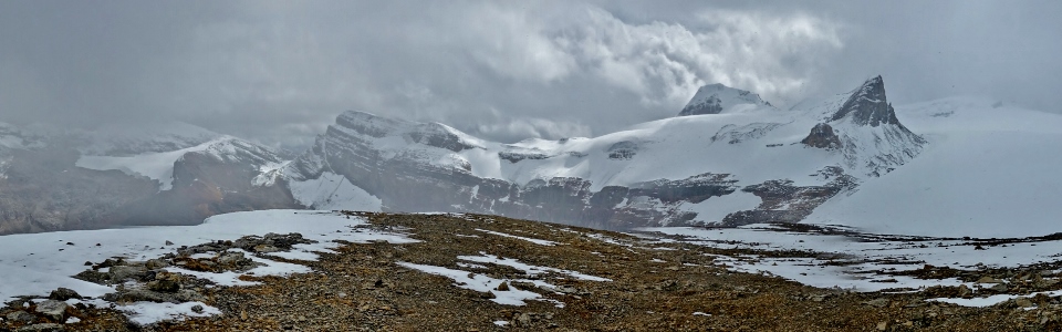
A panoramic glimpse towards the Wapta Icefield reveals a bevy of impressive peaks during a short-lived lull in the squall. From left to right: Mount Crowfoot, Vulture Peak, Mount Olive, pointy Saint Nicholas Peak and icy Mount Gordon. Click to see larger.
.jpg)
The sky briefly breaks atop Vulture Peak, Mount Olive and Saint Nicholas Peak.
.jpg)
Mount Thompson makes a cameo appearance.
.jpg)
By wandering a little further north of the summit, I managed to catch a glimpse of the broken Bow Glacier and Iceberg Lake at its toe. If you use your imagination, you can even see Portal Peak above them! Click to see larger.
.jpg)
An apparition from the Wapta: Mounts Rhondda and Habel emerge from the surrounding whiteout.
.jpg)
Celebrating our anniversary in style! THIS is how you know you’ve found a keeper! Frozen and soaked atop a mountain and still smiling. I love my wife.
.jpg)
After enduring the snowy summit for 10 – 15 minutes, we began our wet descent, making haste towards the warm hut below.
.jpg)
Taking in the view of the crevassed gateway to the Wapta Icefield during a brief side trip towards the glacier on descent. Note the many footprints away from the slots on the right. Mountaineers often use this icy slope to ascend the Onion and other nearby peaks. Click to see larger.
.jpg)
Warming up with a hot cup of tea in the heavenly heated (and humid) hut!
.jpg)
After a quick stop in the hut, we set back out into the cold and made quick work of the 8 km hike back to the car. Having been promised a fancy anniversary dinner capped off with an evening in Deer Lodge’s rooftop hot tub, Brianne was especially motivated and may have set a new land-speed record hiking back down to (and around – ugh) Bow Lake.
.jpg)
Bow Lake provides a beautiful finale to our third anniversary scramble up the Onion. Nothing says “I love you!” like a wet wintery Wapta whiteout! Happy anniversary to my one and only Breezy Goat!
.jpg)
.jpg)
.jpg)
.jpg)
.jpg)