Tangle Ridge Attempt
Elevation: 3000 m
Elevation Gain: 1100 m
Tangle Ridge was named by Mary Schaffer in 1907 as a result of the difficulties that many early parties encountered while attempting to descend Tangle Creek to the north. Despite the name, the ascent of the ridge itself is straightforward and, almost entirely, above the tree line making it an ideal location from which to take in the views of the surrounding icefields.
My Ascents:
August 13 2016 (Attempt), August 4 2013, August 4 2011, September 18 2010.
Trailhead: Tangle Creek Falls Parking
GPS Track: Tangle Ridge (Up to 2800 m Elevation)
After exploring Wilcox Pass the day prior and spending a restless night in a cold tent with a fussy baby, Brianne, Crux and I weren’t exactly eager to get off to an alpine start on the Saturday morning of our family camping trip. Unfortunately for us, Mera had other plans…BIG plans!
.jpg)
“Up and at ’em!” This baby is ready to bag a big icefields peak! (Who could say "no" to a face like that)
.jpg)
At the behest of the baby, we made our way a few kilometers down the highway to the trailhead at Tangle Falls. Since Mera wanted a big peak with expansive views, we decided to give Tangle Ridge a shot, reasoning that the easy scrambling involved might be suitable for the whole family. As we started up the trail (which parallels the highway for a short distance), spirits were high (despite everyone’s lack of sleep the night prior).
.jpg)
Mera has the best seat in the house as Brianne makes her way up the trail from Tangle Falls. As per Kane’s instructions, we followed this trail for about 30 minutes until a spattering of cairns marked the proper spot to cross Tangle Creek.
.jpg)
Crux supervises while Brianne and Mera make quick work of the creek crossing.
.jpg)
Above the creek, we followed the STEEP trail up through the trees. In addition to being STEEP, this trail briefly (and unnecessarily) flirts with a drop-off to the drainage below. I don’t recall this being as big of an issue during previous ascents, leading me to suspect that erosion is at work here. One good rainfall and sections of the trail are liable to be lost! Fortunately, as we neared the tree line, the ascent angle relented and the going became easier.
.jpg)
Release the baby! After spending the last 500 vertical meters in her hiking carrier, Mera was getting eager to explore (and Brianne was getting eager for a break). Gently sloped alpine meadows at tree line, therefore, seemed like an ideal place for Brianne and I to take turns resting while the other adult chased Mera about the hillside, ensuring her safety (which she has little regard for).
.jpg)
My mountain baby!
.jpg)
An impressive icefall highlighted the view across the valley from our break spot at tree line.
.jpg)
“Enough sitting around – let’s go!” As our break drew on, Mera decided that she would just climb the mountain herself! Having never experienced foreshortening, Mera didn’t realize that although it looks near, the summit is actually over 600 vertical meters above us still!
.jpg)
Thinking that Mera might still be a little young to handle the remaining 600 m elevation gain, we loaded her back up into her hiking carrier and resumed our scenic summit bid.
.jpg)
As the alpine terrain turns from grass to solid scree, the views back towards Mounts Kitchener (left) and Stutfield (right) become more and more impressive. You may also notice that Ms. Mera has switched hiking carriers. When we loaded her back into the hiking backpack, she wanted no part of it. After listening to her “protests” for a while, we decided to put her in her more familiar front-facing carrier (which we’d carried up just in case such an eventuality arose). The front-facing carrier was a hit and bought us some much needed time and elevation. Indeed, Mera seemed positively delighted, giggling like a goof while the glacial breeze tickled her. What the front-facing carrier failed to buy us, however, was a nap…
.jpg)
An overtired panorama from high up on Tangle Ridge (click to see larger). As anyone who’s had a baby knows, missing a nap can lead to an unpleasant state where the baby is cranky because they’re tired but too worked up from being cranky to fall asleep. Recognizing that our little one was entering just such a state, we stopped 200 m below the summit in an attempt to nurse/calm her. While Brianne nursed, I took photos of the spectacular scenery, sensing that our summit stay (if it happened) would be brief!
.jpg)
Horn-shaped Nigel Peak rises above Wilcox Lake to the south.
.jpg)
The braided Sunwapta River runs along the foot of Wilcox Peak. To the peak’s left, a vast alpine expanse (Wilcox Pass) unfolds.
.jpg)
Mounts Athabasca (left), Andromeda (right) and their many hanging glaciers.
.jpg)
Brianne enjoys the views of Mount Kitchener while Crux waits patiently. The small highway visible in the valley below makes the vertical relief between us and the trailhead apparent.
.jpg)
Mount Columbia (the highest peak in Alberta) rises up beyond the Kitchener Glacier’s impressive, nearly 1 vertical km, icefall.
.jpg)
Mount Alberta (right) is widely considered the most difficult 11,000 foot peak in the Canadian Rockies.
.jpg)
Six days late for World Breastfeeding Week, nevertheless, I support mothers who want to breastfeed, anytime, anywhere (and at any elevation!). #WBW2016
.jpg)
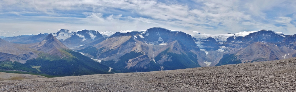
After Mera had eaten her fill, we put her back in her comfy carrier, cuddled into mom’s chest, and hoped that she’d finally take the nap she so badly needed. Alas, she didn’t immediately settle so I took one last panorama before we called it a day and started back down. From left to right: Wilcox Pass, Mount Amery (distant), Hilda Peak, Mount Saskatchewan (distant), Wilcox Peak, Mount Athabasca, Mount Andromeda, Mount “Androlumbia”, Snowdome, Mount Kitchener, Mount Columbia (distant), the South and North Twins (distant) and Mount Stutfield. Click to see larger.
.jpg)
Heading down. The summit was close enough to truly tempt us (after all, we’d come this far) but we decided that continuing on wasn’t fair to our little one. Years ago, I would have been upset by this but, on this day, I didn’t really care. We’d had an amazing day up until this point, so why should not getting to the highest spot on a pile of rocks matter? As I think back to our day now, I have the most wonderful memories of Mera crawling in alpine meadows and giggling at the kiss of the glacial gusts from the nearby icefield. Never have I felt more strongly that a summit wasn’t necessary to have a good day!
.jpg)
Crux looks on as we continue down through pristine alpine meadows. After descending about 100 vertical meters, our fussy baby settled in for a LONG and MUCH-NEEDED nap, sleeping soundly until we reached the valley far below.
.jpg)
Dad might not have been much use when Mera needed to nurse but at least he makes a good packhorse! This was my get-up for the upper 400 vertical meters on Tangle Ridge and the entire descent: empty hiking carrier on my back, VERY heavy pack on my front and a dog pulling on his leash the whole way.
.jpg)
Brianne makes her way down the final stretch amongst colorful wildflowers towards the (suddenly much closer) highway below.
.jpg)
Beautiful Tangle Falls mark the end of our hike. Even though it didn’t result in a summit, I can’t recall a better day in the mountains and can’t wait to make more mountain memories with Mera!
.jpg)
.jpg)