Silly Mountain
Elevation: 648 m
Elevation Gain: 137 m
Silly Mountain is a promotory immediately east of Apache Junction along the Superstition Freeway (US60). The mountain was named for nearby “Silly Mountain Road.” Silly Mountain Road was named by Harry Cadwalader. Cadwalader was a road grader whose family was the second to have a home on the (then) unnamed road. At one point, Cadwalader asked for, and received permission to, name the road. It is unclear why he chose the name “Silly Mountain” but it has since been applied to both the road and the mountain. A steep road used to ascend most of the mountain, however, this has since been restored by the Superstition Area Land Trust and the City of Apache Junction. The area is now a park and a network of trails allows one to explore all aspects of the small peak.
My Ascents:
February 29 2016.
Trailhead: Silly Mountain Trailhead
GPS Track: Silly Mountain
When Brianne, Mera and I left to visit “Nannie” and “Papa” in Apache Junction, my girls were initially concerned that they might not get a chance to bag a desert peak.
“Don’t be silly.” I said. “I have the perfect peak in mind!” ;-)
.jpg)
The view from the trailhead parking: Silly Mountain looking rather small next to one of the area’s large saguaro cacti. You can still make out the remains of the old road which steeply switch-backed up the tiny mountain.
.jpg)
Saguaros jut upwards from the blooming desert floor on Silly Mountain’s slopes.
.jpg)
A splash of yellow in the otherwise arid landscape.
.jpg)
Nannie leads the charge while Brianne and Mera follow her up the “Brittle Brush” trail. A detailed view of the Silly Mountain trail network can be found here. The most direct route to the summit follows the “Old Mine” trail, however, we opted to make a slightly larger loop (descending via the “Old Mine” trail) as the result of some route-finding/map reading issues on Papa’s part. Regardless of how you get to the top of Silly Mountain, you’ll be treated to a pleasant outing!
.jpg)
I guess this is the way to the top?
.jpg)
Huffing and puffing…
.jpg)
Brianne, Mera and Karen wait for me as I investigate the panorama from a small mound at the intersection of the “Huff and Puff” trail and the “Crest” trail. The summit of Silly Mountain can be seen at center left. Click to see larger.
.jpg)
The “Crest” trail leads towards the summit.
.jpg)
Pretty obvious where to go from here!
.jpg)
The final steps to the summit along the “High Point” trail.
.jpg)
♫ Mera’s been through the desert on a Goat with no name, it felt good to be out of the rain. In the desert, Goat can’t remember Goat’s name ‘cuz there ain’t no one for to give Goat no name. ♫
.jpg)
Nannie and Papa take the final few steps up to the silly summit.
.jpg)
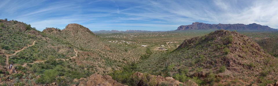
Flatiron Peak and Superstition Mountain dominate the panorama above Apache Junction to the north. Click to see larger.
.jpg)
Tout le gang en haut!
.jpg)
Desert blooms provide a nice frame for Flatiron Peak.
.jpg)
Proud Nannie and Papa.
.jpg)
Looking out over Gold Canyon to the east.
.jpg)
Distant desert hills. I believe that the large peak on the distant right is Picket Post Mountain: a popular local scramble (add it to the “to-do” list).
.jpg)
Proud parents with Mera on top of her second summit – this one proved a little warmer than the last!
.jpg)
Flatiron/Superstition Mountain panorama. This entire massif can be traversed, providing an outing that must be as scenic as it is fun. Click to see larger.
.jpg)
Flatlands stretch out westwards towards Phoenix. Click to see larger.
.jpg)
Usery Mountain (center left) rises up beyond Apache Junction to the west.
.jpg)
Time to GTFD before Mera gets too hot in the desert sun!
.jpg)
Goat earns some serious style points on descent. With a baby strapped to her, she now takes caution to a whole new level!
.jpg)
More desert blooms.
.jpg)
FLOWER.
.jpg)
Winding our way down amongst the wildflowers on the “Old Mine” trail.
.jpg)
Last views towards Flatiron before concluding our silly little hike.
A Horse with No Name from Cathy Benetti on Vimeo.
Because it’s already in your head anyways…
.jpg)
.jpg)
.jpg)
.jpg)