Rummel Ridge
Elevation: 2459 m
Elevation Gain: 700 m
Rummel Ridge is the unofficial name given to the highpoint (GR190335) above Rummel Lake. Like the lake, the Ridge is named for Elizabeth “Lizzie” Rummel. Born in Germany, Lizzie came to Canada as a result of the Second World War. She was a well-known Rockies persona, operating backcountry lodges at Sunburst Lake and Skoki. In 1980, she was awarded the Order of Canada for “sharing her deep love of the Rocky Mountains with all who met her.”
My Ascents:
February 15 2016.
Trailhead: Rummel Ridge Parking (Roadside)
GPS Track: Rummel Ridge
After spending the first 3 days of my 4 day February long weekend with my family, my wife and beautiful baby girl were fed up with me! Crux and I were, therefore, banished to the mountains for a day of (high quality) suffering so that they could enjoy some peace and quiet at home. After checking to see if anyone wished to join me for a post-hole-a-thon in K-Country, I was joined by my sister-in-law Jana and her friend Les (who was told that we were going out for a “snowshoe” not an exercise in masochism)! As we made our way west into K-Country, storm clouds obscured most mountains and gray skies had us convinced that the day would be a workout sans summit views. Fortunately, about a km from our starting point, the clouds suddenly (and somewhat miraculously) cleared and we were treated to bright blue skies and clear views of the Kananaskis peaks!
.jpg)
Although Andrew Nugara suggests that Rummel Ridge be ascended via the popular Rummel Lake trail, we opted to follow a cutline 1.3 km to the north of this trailhead instead. This cutline is located immediately north of a drainage which must eventually be crossed to reach Rummel’s northwest ridge. It is also possible to directly ascend the ridge by starting off on the south side of the drainage, however, this requires one to bushwhack rather than enjoy the open cutline! Rummel’s gentle northwest ridge avoids avalanche terrain which may be encountered along Nugara’s published route and seems to be the more popular ascent option amongst snowshoers these days. From the roadside parking spot, the treed hill that is Rummel Ridge is just visible looking up the cutline (center left).
.jpg)
Crux leads Jana and Les up the well-travelled cutline. The cutline was established as a firebreak during a prescribed burn in 2011.
.jpg)
The sun breaks through the last of the clouds as the charred remains of trees cast their shadows upon us. Beyond the trees in the foreground, you can clearly make out Rummel’s forested northwest ridge on the opposite (south) bank of the now steep drainage.
.jpg)
Crux cools down while the rest of us catch our breath!
.jpg)
The open cutline and steep banks of the nearby drainage provide ample opportunities to take in the views of the surrounding peaks.
.jpg)
After ascending about 300 vertical meters, the cutline side-hills to the climber's right and aims for the shoulder between Mount Engadine and the Tower.
.jpg)
Spectacular views of the Tower’s north face as the cutline side-hills along. Once the Tower is in plain sight, the bank leading down to the drainage on the climber’s right is no longer steep and can easily be crossed to gain Rummel’s northwest ridge. You should note, however, that you may need to cross 2 streams (instead of just 1) if you follow the cutline too far (like we did)!
.jpg)
Crux plows through the deep snow as we cross the first creek. While we’d been lucky enough to follow an old ‘shoe track up the cutline, life got significantly harder as we crossed the creek and were forced to break trail for ourselves!
.jpg)
Hmmm…a second creek? Previous trip reports failed to mention anything about having to cross a second creek. After consulting a topo map, we realized that we’d ascended a little too far up the cut line and, as a result, had to cross 2 creeks (and a ridge in between them) before gaining the correct ascent ridge. If you end up on the ridge between the 2 creeks, use caution as it leads to a significant avalanche slope at the base of the tower. Making matters worse, the descent to the second (more southerly) creek is steep and it was hard to find a safe place to cross. After poking about for a while, we decided to descend this slope (shown here with Les on it). This hillside is definitely steep enough to slide so I would recommend avoiding it by gaining the correct ridge earlier on when only 1 creek crossing is required!
.jpg)
After crossing the second creek, we were essentially committed to Rummel’s northwest ridge since we didn’t want to re-ascend the steep slope we’d just come down! Following a brief gut-buster (which involved breaking trail uphill through belly button-deep sugar snow, we found another old ‘shoe track which we were able to follow up the broad ridge crest. As we gained elevation, we noticed an increasing preponderance of larch trees which eventually gave way to open slopes and a spectacular view of Mount Galatea beyond the summit (right).
.jpg)
A closer look at Mount Galatea’s spectacular north face beneath the mid-winter moon.
.jpg)
Jana and Crux break through the tree line as a stunning view unfolds at their backs.
.jpg)
High winds propel a plume of snow from the summit of nearby Mount Engadine while a more proximate cornice provides evidence of similar phenomena on Rummel Ridge.
.jpg)
Crux wonders how the hell Jana managed to face-plant SO hard. Mouse over to witness the face-plant in its full glory (yes – I stood by taking photos rather than helping her up)!
.jpg)
Les enjoys the sun and the moon simultaneously.
.jpg)
Crux and Les crest the final slopes to the scenic summit of Rummel Ridge!
.jpg)
Back on top with my buddy!
.jpg)
Soaking in the stunning summit panorama to the south. Click to see larger.
.jpg)
Rummel Ridge (2,459 m) is a fine viewpoint but it is completely dwarfed by nearby Mount Galatea (3,185 m)! A frozen and snow-covered Rummel Lake is visible at the base of Galatea’s sheer face.
.jpg)
The panorama across the valley is highlighted by some of the tallest peaks in Kananaskis. Mount French and Mount Sir Douglas (both on the center left) are the 3rd and 2nd highest mountains in K-Country, respectively. Click to see larger.
.jpg)
Rejoice! It’s a beautiful day in the mountains! From left to right: Mount Murray, Mount French, Mount Robertson, Mount Sir Douglas, Mount Burstall (in front of Sir Douglas), Whistling Rock Ridge, Commonwealth Ridge, Commonwealth Peak, Pig’s Tail, Mount Birdwood and Pig’s Back (in front of Birdwood).
.jpg)
Massive Mounts Birdwood (left) and Smuts (right) highlight the view to the west. More diminutive peaks like the Fist and Tent Ridge can also be seen on the right while Sharkfin Peak, Mount Soderholm and White Man Mountain can be seen in the distance beyond Smutwood Pass.
.jpg)
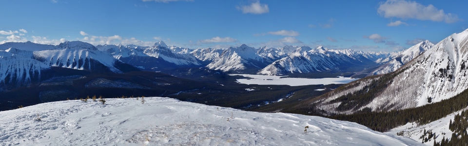
The panorama to the north is equally outstanding, highlighted by Spray Lakes in the valley below and Mount Assiniboine, the tallest peak in the Southern Canadian Rockies, piercing the sky above. Click to see larger.
.jpg)
Crux is such a ladies man.
.jpg)
A closer look at the distant Assiniboine group. Mounts Eon (left), Aye (center) and Assiniboine (right) rise up beyond Mounts Morrison (left) and Turner (right).
.jpg)
The breathtaking view towards Spray Lakes.
.jpg)
A closer look at the peaks above the south shores of Spray Lakes. From left to right: Mount Cautley (distant), Cone Mountain, Mount Mercer (distant), Mount Allenby (distant), diminutive Fortune Mountain and Mount Turbulent.
.jpg)
Crux, Assiniboine and I. Mouse over to see who scored some summit kisses!
.jpg)
A final sun-splashed winter view of the British Military Group before starting our descent.
.jpg)
Jana retraces our steps (more carefully this time).
.jpg)
Rather than enduring the double creek crossing, we simply stuck to an old ‘shoe track and descended the entire northwest ridge. The route was easygoing, if not a little bushy. The brush, however, didn’t deter Jana from hooting and hollering all the way down the mountain one plunge step at a time!
.jpg)
Crux waits for the slow pokes as we re-cross the drainage moments before reaching the highway. Thanks to Jana, Les and Crux for the company and thanks to Brianne for telling me to “take a hike!” ;-)
.jpg)
.jpg)
.jpg)
.jpg)
.jpg)