When fellow suffer-fest enthusiast Mike Mitchell and I began discussing potential objectives for the Canada Day long weekend, we encountered a small snag; I’d already climbed the first 8 mountains that he was keen on! Fortunately, there are countless peaks to bag in the Rockies and we eventually settled on one (Narao Peak) that neither of us had previously ascended. Narao Peak has been on my “to-do” list for many, many years. Of course, my “to-do” list isn’t exactly short so despite the peak’s proximity to the glaciated giants of the Lake Louise/Lake O’Hara area, I’d never gotten around to climbing it. As I re-read Alan Kane’s description and several previous online trip reports, I thought the peak would make for a short, pleasant and scenic outing. It turns out I was wrong on 2 of those 3 fronts! Narao has scenery in spades but I thoroughly underestimated the magnitude of the slog that I had signed up for…
.jpg)
The view of Narao Peak’s west face from the trailhead at the Lake O’Hara parking lot. The peak doesn’t exactly look inspiring from this vantage (indeed, it looks like a very large pile of rubble) but the large cliffs at its far south end hint at the potential for good scrambling up high. Since the standard Kane approach involves bushwhacking through this forest and then slogging up to the ridge crest, we opted to explore alternative ways up…
.jpg)
Listed as an alternative descent in Kane’s description, the route up via Ross Lake looked to be much more interesting than the standard bushwhack/slog. Unfortunately, the old Highway (1A) to the Ross Lake trailhead is closed. We, therefore, had to start from the Lake O’Hara parking lot, covering a little over 2 km on the road’s hard asphalt surface before turning off onto the Ross Lake hiking trail which is so well marked you could see it even if you were hiking at highway speeds!
.jpg)
After a brief stroll in the forest, we emerged at Ross Lake’s lovely outlet, catching our first glimpse of Narao Peak’s snowy summit (dead center) just visible above the massive headwall that we now have to ascend.
.jpg)
The imposing headwall behind Ross Lake. On the suggestion of others, we decided to make our way along the lake’s left (east) shore, passing through a brief section of boggy woods before boulder-hopping our way to the drainage on the lake’s opposite end. From the BOTL (back of the lake), we followed the line of least resistance up towards where the reddish cliffs meet the forest. A STEEP climb from there brought us to the narrow green ledge visible mid-way up the headwall which we traversed via faint goat trail from right to left to reach the hanging valley high above.
.jpg)
Great views of Mount Hector from the drainage at the BOTL.
.jpg)
Mike (faintly visible in the center of the photo) makes quick work of the grassy drainage. High above, the green ledge traverse is apparent.
.jpg)
Despite our attempts to avoid bushwhacking…
.jpg)
Mike embarks on a STEEP line up solid rock to the ledge traverse. I opted to ascend a little further to the climber’s right on the edge of the trees where things looked less insane.
.jpg)
Even on the edge of the forest, the terrain up to the traverse is STEEP! At the very least, however, the trees provided a sense of psychological comfort by somewhat obstructing my view of the drop below.
.jpg)
Done with the vertical (for now), Mike tackles the horizontal traverse towards Divide Peak and the hanging valley ahead. While the view of Ross Lake from this ledge was nice, I didn’t really stop to enjoy it as I had my metaphorical “blinders” on, focusing only on the terrain straight in front of me (and not the massive drop to my left)! Despite my fears, the whole traverse was quite easy. Click to see larger.
.jpg)
The spectacular hanging valley (highlighted by the glaciated north face of Pope’s Peak) at the end of our headwall traverse did not disappoint!
.jpg)
Pope’s Peak (left) and Narao Peak (right) tower above our beautiful alpine surroundings (click to see larger). From here, we larch-whacked in a westerly direction, gaining Narao’s long ridge at its northern end on the far right. Mike more or less gained the ridge directly from the north while I traversed further around to the mountain’s west face and slogged up from there. I’m fairly confident that Mike’s route was better!
.jpg)
Narao Peak’s twin snow couloirs lead dramatically to its twin summits high above. Alpine climbers seem to prefer ascending these steep snow/ice features while H-core skiers enjoy using them to make a “quick” descent.
.jpg)
This is why you should just gain the north ridge directly and not contour around it to the west face. I ascended the choss on the right-hand skyline. Despite the small assist from the obvious snow patch, this route was loose, unpleasant and longer than Mike’s more direct line.
.jpg)
Mike savors the panorama from Narao’s spectacular ridge crest. As Kane notes, the “airy drop” here “discourages aimless wandering”! Click to see larger.
.jpg)
After a pleasant ridge walk, this chimney marks the beginning of the scrambling in earnest.
.jpg)
WOW. Stunning views of Mount Niblock, Mount Whyte, Vatican Peak and Pope’s Peak from high above the hanging valley.
.jpg)
Typical scrambling from the chimney on up. Narao’s north ridge is a series of seemingly impassible buttresses separated by pleasant ridge walks. In all cases, brief by-passes to the climber’s right reveal moderate ascent options.
.jpg)
Mike ascends one of the moderate by-passes to the climber’s right.
.jpg)
This ledge grants a relatively easy (when dry!) way around yet another steep buttress. It is, however, north-facing and, as you can see, holds snow later in the year than other aspects on this peak. When dry, I’m sure that there’s a path leading easily along it but this snow made things much more “interesting” for us. Most of the traverse was still straightforward but there were 1 or 2 steps where a slip would have been very “unpleasant.”
.jpg)
Appreciating the view towards Sherbrooke Lake (left) and Wapta Lake (right) while regaining my composure after our snowy ledge adventure.
.jpg)
At last, Narao’s twin summits and snow couloirs (center) appear beyond, you guessed it, ANOTHER buttress. A path here led straight into the very steep snow on the right so Mike decided to climb straight up the ridge. When I asked him about the exposure on the ridge, he informed me that he didn’t intend to down climb anything he’d just gone up. That answer prompted me to side-hill traverse across miserable boulders just below the snow on the right reaching the right-hand skyline and heading up moderate terrain from there.
.jpg)
A closer look as Mike tackles the more difficult terrain which I opted to avoid.
.jpg)
Mike descends a little to the climber’s right to avoid a quick trip down the couloir as the first summit is FINALLY within striking distance! By now, we’d been on the go for almost 7 hours which was about as long as I told my wife that it would take to ascend AND descend Narao. Like I said earlier, I underestimated this mountain (and as an unfortunate consequence had a worried wife wondering why she hadn’t received my SPOT summit message 7 hours into things – sorry Boss)!
.jpg)
Mike reaches the summit while I bust a gut trying to suffer up the steep final rubblefuck of a slope. When I finally reached the summit, I was completely bagged…
.jpg)
…then again, a summit panorama this awesome can quickly give you your second wind! Click to see larger. Those with a keen eye may notice that a tiny Mike is already on Narao’s second summit (center left). According to his GPS, the second summit was 3 m higher than the first. As the first summit had the cairn and register, however, I was perfectly happy to catch my breath while soaking in the view there! With regards to which summit is "official", the summit coordinates listed by Natural Resources Canada match those of the slightly lower first summit.
.jpg)
Tiny Vatican Peak sits across a glaciated col from much larger Pope’s Peak. Beyond the col, Protection Mountain (TV Peak) is visible across the Bow Valley.
.jpg)
Mike takes in the impressive view of Collier Peak from Narao’s second summit.
.jpg)
The breathtaking view of Mount Victoria’s heavily glaciated north face is, bar none, the highlight of a scramble up Narao Peak!
.jpg)
The Goodsirs tower above Park Mountain (which in turn towers above diminutive Wiwaxy Peak). Thanks to clear skies, we were even granted views of the distant multi-spired Bugaboos (center right).
.jpg)
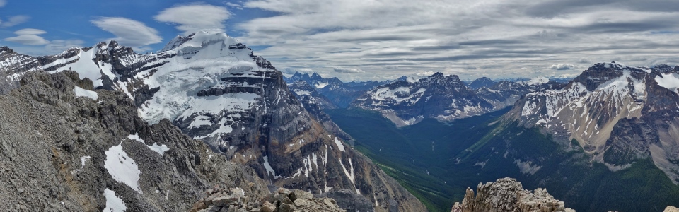
Beautiful British Columbia indeed! Click to see a larger view of the western panorama.
.jpg)
Distant Chancellor Peak (center left) and glaciated Mount Owen can be seen beyond Odaray Mountain. To Odaray’s right, Mount Hurd is obvious and Syncline Mountain can be seen some 70 km away.
.jpg)
Nearby Cathedral Mountain is as eye-catching as any church on the planet.
.jpg)
Mount Stephen's snowy ledges rise above the Cathedral Crags.
.jpg)
Yoho National Park and the Waputik Icefield stretch out to the north beyond a very happy (but very bagged) scrambler.
.jpg)
Too many peaks to name. But I’ll try anyways! From left to right: Mount Sir Sanford (distant), Mount Carnarvon (with much smaller Emerald Peak at its base), Wapta Mountain, Mount Laussedat (distant), Mount Marpole, The President, The Vice President and Mount McArthur.
.jpg)
Mount Ogden (left) and Paget Peak (right) bracket Sherbrooke Lake while Mounts Niles and Balfour rise up above the Waputik Icefield on the right. In the distance, the sea of peaks includes (from left to right): Mount Mummery, Isolated Peak, Whaleback Mountain, the Freshfield Icefield, Arete Peak, Mount Des Poilus, Yoho Peak, the Lyells, Mount Forbes, Mount Collie, Ayesha Peak, Mount Outram, Mount Baker and Mount Habel.
.jpg)
Narao’s long ascent ridge (left) winds down towards the green hanging valley that we approached via. Across the alpine plateau, the Alberta/BC border runs along Divide Peak’s ridge towards Pope’s Peak. Click to see larger.
.jpg)
Mounts Niles (left), Balfour (center left) and Daly mark the beginning of icefields which stretch far to the north along the spine of the continent. Beyond the Bath Glacier at Mount Daly’s foot, many-towered Mount Murchison can be seen in the distance while Observation Peak is just visible on the far right.
.jpg)
Mount Bosworth and Waputik Peak (left) give way to the Icefields Parkway and massive Mount Hector (center) while snowy Cataract Peak can be seen on the center right.
.jpg)
Mounts Douglas (left) and St. Bride (right) rise above a sea of Skoki peaks (Pika Peak, Ptarmigan Peak, Fossil Mountain, Redoubt Mountain) and the Lake Louise ski resort on Whitehorn Mountain (foreground).
.jpg)
A closer look at Mount Niblock’s summit block. The fun scramble route to the top follows the right-hand ridge.
.jpg)
The difficult summit block of Mount Whyte.
.jpg)
A final summit shot with the very sexy Ms. Victoria before starting the long descent.
.jpg)
What goes up rotten rubble, must come down rotten rubble.
.jpg)
Mike reaches the chimney on descent. From here, we opted to plot a direct course down the steep ankle-breaking boulders on Narao’s west face, aiming for a prominent avalanche gully which So Nakagawa also used on descent. This descent route involved short down climbs of several rock bands; fortunately, none involved more than moderate scrambling. Easier, more rubble-strewn descent options existed further to the skier’s right (north) but we didn’t end up needing them.
.jpg)
Looking back up at our descent route. The chimney is located on the ridge-top buttress at the center of the photo and we essentially made our way straight down from there (including the down climb of the small waterfall which only looked to be a wet smudge from above). Below the waterfall, Narao mercifully abetted and we found a pleasant scree chute descending the rest of the way to a prominent alpine bench.
.jpg)
Mike allows his feet to enjoy the wonderful sensation that is soft grass while taking in the impressive views of Cathedral Mountain from the alpine bench. By this point, the rubble is behind us but the descent is only about half done.
.jpg)
Looking back up at Narao’s many, many buttresses from the alpine bench. The peak certainly looks more imposing from here than it did from the Lake O’Hara parking lot this morning!
.jpg)
Mike makes his way down So’s avalanche gully towards the Lake O’Hara road below. Despite So’s note that this avalanche gully “wasn’t great,” we found it to be quite reasonable. By taking the more open left branch lower down, we were able to follow the avy path to within a very short distance of the road.
.jpg)
A brief walk through thin forest at the bottom of the avalanche path – the soft moss underfoot actually made this one of the more pleasant sections of the day!
.jpg)
The long road home…After hearing an engine from the forest, we sprinted to the road hoping that the Lake O’Hara bus driver would take mercy on some exhausted scramblers. Instead, he casually shrugged his shoulders at us and drove by as we extended our thumbs to hitch a ride (despite the fact that his bus had ONLY 2 passengers aboard)! What followed was a foot-numbing 3 km march down the rock hard road. If the driver wasn’t going to alleviate our suffering by giving us a ride down, he could have at least ended it by not swerving around us! Regardless, after covering about 16 km and 1380 vertical meters (I’m not sure where Kane’s figure of 1225 vertical meters comes from!), Mike and I finally reached the parking lot and parted ways.
Narao Peak certainly wasn’t the short day I thought that it would be! Its combination of steep, gut-busting rubble slopes and breathtaking summit scenery left me feeling like I’d been “hit in the stomach”. Maybe that’s how Narao Peak really got its name? Regardless, as my achy feet, knees and back fade away, all that remains are memories of a spectacular day in the Rockies!
.jpg)
.jpg)
.jpg)
.jpg)
.jpg)
.jpg)