This year, Brianne decided to give me a most-wonderful present for my birthday: an adult peak-bagging day for just the 2 of us. Don’t get me wrong, I love my baby girl but I’ve also missed having my “Breezy Goat” along on some of my more “hands-on” mountain adventures. With a blessing from Mother Nature (in the form of a rare sunny day) and an assist from Grandma (thanks for babysitting!), we, therefore, set out to attempt Mount Norquay via the moderate south ridge route recently published in Kane’s updated “Scrambles” guidebook.
We had hoped to ascend Norquay’s south ridge directly, however, it was very difficult to locate the starting point that Kane mentions when travelling on the busy TransCanada highway! As we saw nothing obvious when passing by at 90 km/hour, we instead drove to the alternate “Fireside” trailhead a couple of kilometers further west on Highway 1A. When driving home later in the day, we were able to spot the starting point directly at the base of the south ridge. As indicated in the guidebook, there is a gate in the wildlife fence 3.4 km west of the Banff west overpass; there is, however, no pullout here and you simply have to park on the side of the highway. The spot where you should pull off to use this gate is directly behind a large sign that indicates the exit for the Bow Valley Parkway in 2 km.
.jpg)
From the Fireside trailhead, we set off along the popular Cory Pass trail and reached the signed Cory Pass – Edith Pass junction 1 km later. Failing to locate Kane’s faint trail, we decided to “grass-whack” straight downhill towards the highway and obvious power lines.
.jpg)
Once underneath the power lines, the “grass-whack” continued along a faint trail towards the treed south ridge of Mount Norquay. While travel below the power lines was easy (unless you have grass allergies…), it would have been nice to park right at the base of the south ridge as this all-together eliminates the 2 km approach via Fireside.
.jpg)
Underneath the power lines and on the south ridge. Time to go UP (capitalized for EMPHASIS)!
.jpg)
The lower sections of Norquay’s south ridge are currently littered with flagging tape which bears warnings of “rare plants” and advises scramblers to “stay off cliff face to w (west?).” We weren’t sure what to make of these warnings and they briefly confused us to the point where we thought that perhaps we were supposed to be on the next ridge to the east. Ultimately, we pretty much ignored the flagging and stuck to our ridge (which eventually merged with the more easterly one anyways).
.jpg)
UP, UP, UP! The view of the TransCanada Highway below provides an indication of the steepness of Mount Norquay’s south ridge…
.jpg)
Did I mention that the south ridge is steep?
.jpg)
Beautiful views towards Banff to the east provide a good excuse to stop for a breather.
.jpg)
The views to the west aren’t too shabby either! Unfortunately, most of the views on ascent are blocked by the lightly forested south ridge itself (which is as uninspiring as it is steep).
.jpg)
As we neared the alpine, our ridge merged with that immediately to the east (right hand skyline in this photo) and the ascent angle finally began to relent.
.jpg)
Above the tree line, we were finally granted a good view of the ridge ahead with its many ups and downs. After ascending 900 m in a merciless 3 km, Brianne was now cursing the fact that the summit still appeared to be so far away (and that was before she knew that the shaded high point visible here is actually the false summit)!
.jpg)
Beautiful views of Banff unfold to the south as Brianne makes her way up the rocky ridge.
.jpg)
The south ridge itself involves some pleasant moderate scrambling on good, solid rock. We were occasionally tempted to by-pass the ridge crest when it looked like it was about to become difficult but the difficulties never came to fruition. Despite appearances, I felt that the scrambling along the ridge crest was on the easier side of moderate.
.jpg)
As we reached (what appeared to be) the summit, Brianne was aghast to see that a higher point (center right) lay further ahead (hidden until now). Fortunately, this next obvious high point was the true summit and, better still, it wasn’t nearly as far away as she initially thought! The only problem appeared to be getting there as the terrain dropped off rather sharply beyond the false summit…
.jpg)
A narrow ledge to the climber’s left (west) allowed us to by-pass what looked to be a difficult down climb from the false summit.
.jpg)
Looking back towards the false summit. As you can see, the down climb directly along the ridge crest is reasonably exposed here! Mouse over to see our westerly ledge by-pass which allowed us to keep the scramble in solid “moderate” territory. This was the only place along the ridge where I felt that a by-pass was advisable.
.jpg)
The ridge just keeps going and going and going…
Despite what Brianne will tell you, it wasn’t actually that bad! :-P
.jpg)
The reward for our persistence: a beautiful Banff bounty from the true summit! Click to see larger.
.jpg)
Banff landmark Cascade Mountain (left) rises up beyond Mount Norquay’s lower east peak while Mounts Inglismaldie, Girouard and Peechee highlight the view of the more distant Fairholme Range on the right.
.jpg)
A pair of climbers (bottom center) traverse the eastern peak’s exposed ridge. Perhaps they ponied up the $299(!) required to take the via ferrata all the way up Norquay’s lower peak?
.jpg)
A happy birthday summit with my favorite climbing partner (sorry Crux!).
.jpg)
A closer look at majestic Mount Rundle and the town of Banff below (without the scramblers in the way this time).
.jpg)
Looking south towards Kananaskis and Mount Assiniboine Provincial Parks while Brianne enjoys a summit refreshment. “You’re going to share that Gatorade, right Honey?”…
.jpg)
Distant K-Country views reveal a throng of familiar peaks (from left to right: the Middle Sister, Mount Lougheed, the Big Sister, Mount Sparrowhawk, Mount Bogart, Mount Buller and Old Goat Mountain) above Spray Lake.
.jpg)
Glaciated 11,000er Mount Sir Douglas (right) highlights the view towards the British Military Group deep in Kananaskis Country.
.jpg)
The Matterhorn of the Rockies Mount Assiniboine beyond Nasswald Peak (right).
.jpg)
A sea of peaks rise up above the Bow Valley to the south. From left to right: Sundance Peak, Mount Assiniboine, Nasswald Peak, Golden Mountain, Fatigue Mountain, multi-spired Mount Howard Douglas, Eagle Mountain (aka: Goat’s Eye Mountain), Mount Shanks, the Monarch, Mount Wardle and Mount Bourgeau.
.jpg)
The beautiful blue waters of the Bow snake their way through the valley. If you look closely, you can spot a helicopter over the river on the center left.
.jpg)
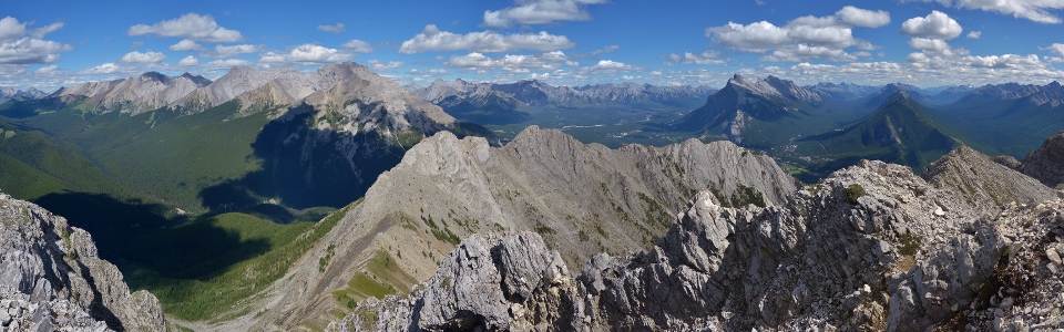
Beautiful green valleys highlight the panorama to the north and west. Click to see larger.
.jpg)
Glaciated Mount Ball peeks out over Mount Cory’s flank to the west.
.jpg)
Birthday boy.
.jpg)
Great views of the jaw-droppingly vertical strata of Mount Edith (South, Central and North peaks), Mount Louis and Mount Fifi with larger Mount Cory rising up in the background.
.jpg)
Looking north towards nearby Mount Brewster while Brianne texts the babysitter to update her on our progress!
.jpg)
Soaking in the summit panorama before starting our return trip down the south ridge. Click to see larger. After taking 4.5 hours to ascend, we didn’t linger too long on top as we didn’t want Grandma to be stuck babysitting past her bedtime (of course we hadn’t factored in the long weekend traffic at this point…)!
.jpg)
Brianne starts to make her way back towards the false summit (right).
.jpg)
Spectacular ridge walking! The upper sections of Norquay’s south ridge were the highlight of my birthday. The ridge was generally easy, allowing you to enjoy the amazing alpine views with occasional hands-on bits to keep you on your toes. Really, really pleasant scrambling in my opinion (pity the going was so much less pleasant below treeline)!
.jpg)
My “Goat” back in her element!
.jpg)
Descending through the south ridge’s steep, open forest. With the awesome ridge walk now behind us, the remainder of the descent kind of sucked!
.jpg)
Like I said…STEEP (note the angle of the slab which we just descended behind Brianne)! As the day wore on, Brianne and I started to tire (we don’t get out as much as we used to!). Unfortunately, we weren’t able to relax until we were all the way down the south ridge (it really never lets up). From the base of the ridge, however, we made relatively quick work of the 2 km hike back to the Fireside trailhead and were soon enjoying birthday pizza in Canmore while throngs of Calgarians clogged up the highway home.
We may not have loved the lower parts of Norquay’s south ridge but it really was fun up high. Most of all though, it was great to get back out and suffer with my wife; Thanks Boss – I had a great birthday!
.jpg)
.jpg)
.jpg)
.jpg)