Moose Mountain
Elevation: 2437 m
Elevation Gain: 750 m (cummulative)
Moose Mountain was so-named in 1949 as a result of its (supposed) resemblance to a resting moose on the horizon. The peak is the site of a forestry service fire lookout and is a popular hiking objective due to its proximity to Calgary. As many as 8,000 ascents per season are recorded!
My Ascents:
August 27 2016, November 6 2011, July 19 2010, May 28 2009.
Trailhead: Moose Mountain Parking
GPS Track: Moose Mountain
Like her father, baby Mera tends to get restless at home in the city. After a Friday spent watching her doing laps up and down our stairs, Brianne and I decided that some REAL elevation gain was in order for Saturday to burn off some of Mera’s excess energy. Since (honorary) Aunty Jenn had previously asked to join us on a baby hike sometime, we invited her along.
Moose Mountain has been on Mera’s to-do list for a while (at least 10 months). Indeed, when it comes to babies, Moose Mountain has a few things going for it. Amongst them:
1) It’s close to Calgary (babies don’t care for long drives).
2) It’s a reasonably impressive-looking front range peak (babies are very concerned with aesthetics when it comes to peak-bagging).
3) A good trail ascends all the way to the summit (babies don’t care for bushwhacking).
4) You can drive half way up it (this is more of a perk for Mom and Dad who won’t be stuck carrying the baby ALL the way up the mountain)!
With the above factors in mind, Mera therefore set out for Moose Mountain (with Mom, Dad, Jenn and Crux in tow).
.jpg)
One of the downsides of driving half-way up the mountain is the fact that you quickly lose elevation (100 m!) when you start hiking anyways. Hikes aren’t supposed to start by going downhill. Of course, this is much less of an issue at the start of the day than it is at the end when you have to hike back up!
.jpg)
Aunty Jenn and Brianne pause for a photo early on with the objective directly behind them. While the summit looks far away from here, that appearance is (fortunately) deceiving!
.jpg)
Much of the hike’s first few kilometers are spent amongst the forest. Occasional meadows, however, grant pleasing views towards nearby unnamed peaks.
.jpg)
As we continued to hike along the wide fire road, overcast skies shaded us from the summer sun and provided some nice photographic opportunities thanks to dramatic clouds.
.jpg)
Aunty Jenn and Mera strike up a conversation at treeline; perhaps they’re discussing the switch-backed route up the false summit ahead?
.jpg)
Somebody needs a nap (and it’s not Brianne). Normally Mera naps on the drive out to the mountains when we’re hiking. On this day, however, that drive was too short for a proper nap!
.jpg)
Jenn and Brianne make quick work of the switchbacks up the false summit while Mera (thankfully) naps aboard her mom.
.jpg)
From the false summit, the remainder of the way up to Moose Mountain’s lookout-adorned summit looks somewhat daunting. Again, this appearance is deceiving!
.jpg)
Aunty Jenn confidently tackles the steep rock thanks to an excellent path.
.jpg)
Brianne and Mera on summit approach. By this time, the cold summit wind had roused the little one from her nap. Ah – to wake up from a cozy nap atop a mountain peak!
.jpg)
Mera explores the 2,437 m high summit of Moose Mountain: just another day in the life of a peak-bagging baby.
.jpg)
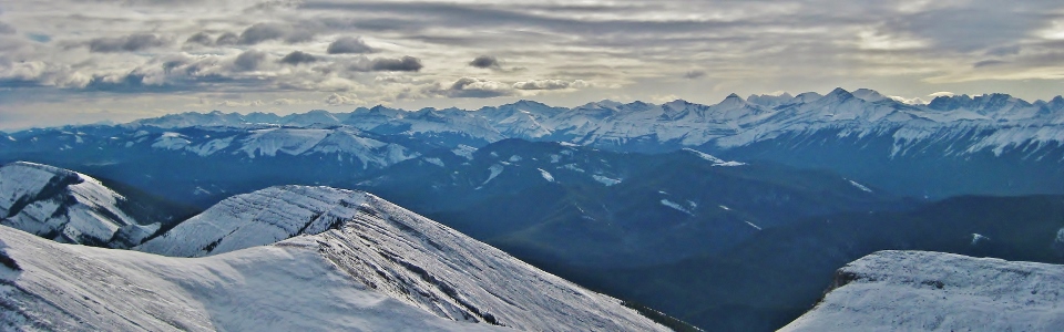
Although the lighting was less than ideal, the panorama of larger summits to the west of Moose Mountain was still impressive. Indeed, familiar peaks as far away as Banff and Canmore are still visible. Click to see larger.
.jpg)
Canyon Creek runs along the foot of Compression Ridge (center). Further left of Compression Ridge, Fisher Peak is also visible.
.jpg)
Mount Bryant (center left) dominates the foreground to the west while Kananaskis Range peaks dot the horizon beyond. Pyramidal Mount Bogart is the obvious high point on the right-hand horizon.
.jpg)
Sun-splashed Tiara Peak (center left) Belmore Brown Peak (center), Jumpingpound Mountain (right foreground) and the twin summits of Midnight Peak eventually give way to more impressive K-Country peaks (from left to right: Mount Sparrowhawk, Wind Mountain, Mount Lougheed and the Three Sisters (Faith Peak, Hope Peak and Charity Peak)).
.jpg)
Soon she’ll be walking atop summits on her own (but for now, Daddy doesn’t mind helping).
.jpg)
Dramatic lighting highlights Moose Mountain’s many outlying peaks to the south. Click to see larger.
.jpg)
Moose Dome Creek winds its way south and east of the peak towards the forested foothills and prairies beyond. Popular Prairie Mountain can also be seen in the right-hand middleground.
.jpg)
Looking south, forested Powder Face Ridge gives way to a host of larger peaks including (from left to right): Mount Burns, Mist Mountain, Cougar Mountain, Storm Mountain, Banded Peak, Mount Rae, Outlaw Peak, Mount Glasgow and Mount Cornwall.
.jpg)
“Arrow-straight” Nihahi Ridge (left) eventually becomes more convoluted Compression Ridge (right). Behind them, Mount Fullerton (center left) and Fisher Peak (center right) are visible as well.
.jpg)
Aunty Jenn enjoying her hike with the Hobbs’!
.jpg)
Crux enjoys the cool wind atop yet another mountain.
.jpg)
To the north, Moose Creek flows down the valley towards expansive flatlands.
.jpg)
The On-Top family summit photo (before hastily descending to escape the wintery wind)!
.jpg)
A beautiful prairie panorama as Aunty Jenn and Mom/Mera make their way back down towards Moose Mountain’s broad false summit. Click to see larger.
.jpg)
Other hikers make their way along the Moose Mountain fire road as the Calgary skyline (center right) can faintly be seen through the haze to the east.
.jpg)
Our descent was largely unremarkable (as one might expect on a baby-friendly peak like Moose) with one exception: the homicidal psycho grouse! After escaping the terrifying beast (without resorting to kicking and screaming like some yoga pants-clad ninnies), we made quick work of the remaining hike back to the car including the always popular 100 vertical meter grunt back up at the end. After a quick drive home, we set Mera down, collapsed on the couch and watched as the baby started back up the stairs…
.jpg)
.jpg)
.jpg)