Wind Ridge
Elevation: 2200 m
Elevation Gain: 780 m
Wind Ridge is named for nearby West Wind Pass and Mount Lougheed (which was originally named Wind Mountain by Eugene Bourgeau in 1858). To say that wind is a prevailing theme in the area’s nomenclature is an understatement. Even the local Stoney aboriginals referred to Wind Ridge as Ganutha împa, which means “Windy Point.” The ridge’s scenic high point appears in Pink Floyd’s iconic “Learning to Fly” music video and has also been the site of a piano (grand, no less) performance by Canadian pianist Frank Mills.
Regulatory Note: Signs in the valley suggest that the area is closed from December 1 until June 15 annually, however, a 2013 edition of Gillean Daffern's Kananaskis Country Trail Guide states that this closure does not apply to the trail leading to the summit.
My Ascents:
May 18 2015.
Trailhead: Mount Lougheed Viewpoint
GPS Track: Wind Ridge
After spending the first 2 days of my May long weekend building a fence with the help of family, I was thrilled to be finishing up on Sunday night. Fence construction is serious business and after 2 long days, I was ready for some much needed mountain R&R on Holiday Monday! Following a rainy start to the long weekend, Victoria Day promised to be spectacular in the Rockies. While I was tempted to tackle a large objective, getting off to my customary alpine start proved challenging as a result of fence-related exhaustion and one too many post-fence beers. As I dragged my ass out of bed and got on the road at 9am, I decided that a short objective was in order. Having never been up Wind Ridge near Dead Man’s Flats, I opted to give it a go, reasoning that it would be a good candidate to provide an outstanding scenic return on a relatively small energy/sweat investment. This proved to be an excellent call; as is so often the case, the views from a small peak, surrounded by much larger ones, proved outstanding! Better still, thanks to some ambiguity concerning whether or not a trail closure was in effect, Crux and I avoided the long weekend crowds and had the peak all to ourselves!
.jpg)
A promising start! It’s always a good sign when the panorama from the trailhead parking (at the Mount Lougheed viewpoint just south of Dead Man’s Flats) is this good! Wind Ridge is the forested hill on the right.
.jpg)
After starting off toward Wind Ridge along an old logging road, we quickly passed the turnoff for Skogan Pass and continued straight downhill. A 10 minute hike brought us to Pigeon Creek(s) where a bridge existed prior to the 2013 floods. Depending on your route, there are 2 – 3 separate creek beds in very close proximity; none poses any challenge to rock-hop across. Flood damage near the creek(s) makes it tricky to follow the trail and some quick bushwhacking may prove necessary. Your goal should be to head due west from here, crossing 3 creek beds. On the west bank of the most westerly creek, you’ll find a wide logging road trail which runs parallel to the creek. This trail angles uphill in a southerly direction towards Wind Ridge and, although heavily eroded, is readily passable.
.jpg)
About 10 minutes after leaving Pigeon Creek(s) behind, you should come to an obvious fork in the trail where 2 old roads diverge. Straight ahead continues towards Centennial Ridge and Mount Allan while the right-hand branch will take you west up a series of steep hills towards Wind Ridge.
.jpg)
Crux and I followed the trail upwards, pleased to finally gain some elevation, before reaching the well-marked short-cut trail shown here 20 minutes after the fork. This small trail nips quickly through the forest and deposits you on yet another decommissioned road minutes later. From this point-on, the ascent should be fool-proof; simply follow the obvious trail up as it contours around easterly slopes towards Wind Ridge’s more open south aspect. If these approach directions seem a little convoluted to you, feel free to "cheat" and download my GPS track!
.jpg)
Upon reaching the grassy south slopes, the rest of the route along the broad ridge towards the high point on the left is revealed. During mid-summer months, these slopes are likely littered with wildflowers.
.jpg)
These open slopes also reveal an outstanding panorama as Lougheed I, the Windtower, Rimwall Summit and the Orphan form a formidable wall above Wind Valley. Click to see larger.
.jpg)
Snow-capped Goat Mountain appears beyond West Wind Pass.
.jpg)
Heating up…with the strong May sun beating down, Crux was relieved to find small patches of snow here and there.
.jpg)
Approaching the crux rock band; an easy hands-on step provided that you have hands not paws!
.jpg)
Crux at the crux. I didn’t feel like lifting Chubosaurus up the rock band (he’s over 100 lbs now!), so we followed the by-pass trail which contours right below the rock band before ascending steeply in trees on Wind Ridge’s north aspect. Later in the year, this by-pass would be steep but easy, however, its position in north-facing forest ensured an icy ascent for Crux and I on this particular May day.
.jpg)
Once back on the ridge proper, I spotted a group of ewes and calves enjoying the peace and quiet of Wind Ridge’s grassy hillsides. Crux and I gave them their space and they, in turn, gave us ours. Mouse over for a closer look.
.jpg)
Above the crux rock band, the rest of the route to the top is mellow and scenic! Click to see larger.
.jpg)
A short time later, we arrived atop the grassy high point and were quickly greeted by a couple of summit ticks!
.jpg)
My tick magnet and Mount Lougheed.
.jpg)
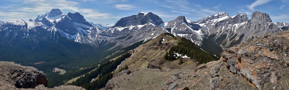
Enjoying a spectacular summit panorama whilst humming Pink Floyd to myself. From left to right: Mount Allan, Wind Mountain, Mount Lougheed, the Windtower, West Wind Pass, Rimwall Summit, the Orphan and the Three Sisters (Faith, Hope and Charity Peaks). Click to see larger.
.jpg)
The Mount Lougheed massif – from left to right: Wind Mountain, Lougheed III, Mount Lougheed, Lougheed I and the Windtower.
.jpg)
Summit selfie. I really should train Crux to take summit photos of me…
.jpg)
Mount Birdwood, the Fist and Mount Smuts tower above Tent Ridge beyond West Wind Pass.
.jpg)
A closer look at Rimwall Summit’s rampart-like east face.
.jpg)
My latest desktop background.
.jpg)
The Orphan.
.jpg)
A closer look at Faith, Hope and Charity – the iconic Three Sisters.
.jpg)
Crux enjoys a patch of summit snow away from the tick-infested grass. He also got to enjoy his own PB&J sandwich since his negligent owner let his entire kibble supply run out at home!
.jpg)
The eastern panorama overlooking Wind Valley. Click to see larger.
.jpg)
The Trans-Canada Highway winds its way east along the base of Pigeon Mountain (right) and past Lac des Arcs towards the extensive prairies.
.jpg)
A colorful freight train meanders alongside the Bow River below Old Goat Mountain.
.jpg)
Skogan Peak (center left) and Mount Lorette (center right) beyond the Skogan Pass cut line to the east.
.jpg)
Distant Tiara Peak.
.jpg)
Mount Collembola.
.jpg)
The panorama to the west towards Canmore. Click to see larger.
.jpg)
Bow Valley landmarks Mount Rundle (left) and Cascade Mountain (right) above Canmore.
.jpg)
Popular Canmore scrambles: Mount Lawrence Grassi (left), Ha Ling Peak (center) and EEOR (right).
.jpg)
The Fairholme Range extends to the northwest beyond Grotto Mountain.
.jpg)
Sandwiched between Three Sisters and an Orphan – the On-Top summit shot before heading back down.
.jpg)
As Crux and I made our way back down, we opted to head down open south-facing slopes to breach the crux rock band rather than slip and sliding our way down the icy north-facing by-pass trail. Our improvised descent route provided an easy way down, albeit at the cost of having to side-hill our way back towards the ridge and the trail afterwards.
.jpg)
A massive antler would have made a tempting chew toy for Crux but he didn’t even notice it in his rush to get back to the trail and put an end to the steep side-hilling.
.jpg)
Once we made our way back to the trail, we retraced our steps back down under the hot afternoon sun. Poor Mr. Crux really started to feel the heat about half-way down, so we stopped for a long break at in Pigeon Creek before finishing off the day and heading back home to admire our new fence. Mouse over to see an incredibly happy hot dog.
Pink Floyd - Learning To Fly (Official Music... by BigDaddyAEL1964
It was stuck in my head all day and now I'm going to get it stuck in yours! :-P
.jpg)
.jpg)
.jpg)
.jpg)
.jpg)