Volcano Peak (Little McDougall)
Elevation: 2554 m
Elevation Gain: 1050 m
Sometimes referred to as “Little MacDougall,” Volcano Peak is an unofficially named high point on the Mount MacDougall massif. The peak was named by Andrew Nugara for the cinder cone-like appearance of its summit. Despite appearances, the origin of this feature is not volcanic. In fact, Volcano Peak’s summit is simply made up of rock from a different geological formation than that which it sits atop.
My Ascents:
March 29 2015
Trailhead: Evan Thomas Day Use Area
GPS Track: Volcano Peak
After suffering through another work week, it was once again time to get out to the mountains for some higher quality suffering of a different variety! Having whetted my appetite for bushwhacking on an attempt of Labyrinth Mountain the week prior, I decided to investigate the reportedly unpleasant brush on Volcano Peak! As is often the case, only Crux was willing to join me in my quest for suffering of the highest quality.
Arriving at the Evan Thomas trailhead, Crux and I were greeted by a howling wind and overcast skies. As we slipped and slid our way along the ice sheet that is, apparently, a passable trail in the summer time, I found myself wondering what the hell I enjoy about peak bagging. Remembering how bored I eventually got watching Netflix while it rained outside the day previous, we pressed on.
.jpg)
Despite a general lack of scenery on the approach trail, the views occasionally opened up thanks to the damage which Evan Thomas Creek inflicted upon the landscape during the Great Floods of 2013.
.jpg)
Continuing past the “Trail not maintained beyond this point” sign and then the cairned trailhead for Old Baldy Ridge/Mountain, I eventually noticed some flagging on trees as the trail turned abruptly west for a short distance. Following the flagging through the woods to the east, Crux and I quickly emerged into an opening created by an old burn. From here, we were granted an unobstructed view of Volcano Peak’s bushy ascent slopes straight ahead.
.jpg)
Let the thrash begin!!! Crux leads us up through ever thickening brush on an ever steepening slope. Surprisingly, we eventually heard someone else snapping through the grabby shrubs. We paused to exchange pleasantries (despite not being able to see one another through the thicket) before continuing upwards.
.jpg)
Upon reaching more open slopes a couple hundred meters above the burn, Crux and I were finally able to see the other foolhardy bushwhacker. While this point marked the end of the dense bush, it marked the beginning of ankle-breaking talus slopes. While these boulders aren’t pleasant for humans, they’re less-so for dogs, so Crux and I traversed towards trees to the climber’s right and picked our way carefully up amongst them.
.jpg)
Improving views of nearby Fisher Peak as we work our way up into the alpine.
.jpg)
Above the tree line, hard-packed snow allowed for easier travel without having to worry about ever-shifting boulders. The snow proved just hard enough to support Crux’s weight, however, I (being much fatter than Crux) was relieved to have my snowshoes with me!
.jpg)
Crux pauses to enjoy the view from the base of the summit "cinder cone."
.jpg)
Following a quick jaunt up the "cinder cone," we were treated to a beautiful easterly panorama from Volcano’s summit. This is the type of reward that qualifies “suffering” as being “high quality!” At the very least, it’s more entertaining than binge-watching Netflix! Click to see larger.
.jpg)
Rather surprisingly, Old Baldy Mountain is the highest point on the MacDougall massif (and not Mount MacDougall itself).
.jpg)
Crux enjoys his summit seat as Mount MacDougall (left) and a more distant Mount Bryant (center right) rise to the east.
.jpg)
Fisher Peak (left) and the Opal Range (right) highlight the view to the south.
.jpg)
The peak-bagging pooch enjoys his view of the Kananaskis Range to the west.
.jpg)
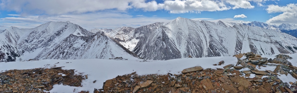
A cloudy Kananaskis Range panorama (from left to right): McKay Mountain, Mount Inflexible, the Wedge, Mount James Walker, the Fortress (cloud-covered), Mount Galatea (cloud-covered), the Tower (cloud-covered), Mount Kidd’s South Summit, Mount Kidd, Mount Bogart (cloud-covered), Ribbon Peak, Mount Sparrowhawk (cloud-covered), Wind Mountain (cloud-covered), Mount Lougheed (cloud-covered), Mount Allan and Mount Collembola. Click to see larger.
.jpg)
Mount Lawson, Mount Inflexible, Mount James Walker and the Fortress beyond McKay Mountain, the Wedge and Limestone Mountain.
.jpg)
Spring encroaching on the flood-ravaged Kananaskis Valley below while winter maintains its icy grip above.
.jpg)
Summit "sufferer."
.jpg)
A closer look at the South (left) and true summits of Mount Kidd.
.jpg)
Looking beyond Old Baldy Ridge towards the Nakiska ski resort and Canmore corridor.
.jpg)
A closer look at Mounts Allan (center left) and Collembola (right).
.jpg)
Looking north towards Skogan Peak (center left), Mount Lorette (center) and the peaks of the Ghost Wilderness beyond.
.jpg)
Crux attempts to sniff out the summit register (he didn’t find one).
.jpg)
After a scenic but windy stay on top of Volcano Peak, Crux and I began our descent by retracing our footsteps/paw prints.
.jpg)
Closer to the tree line, we rejoined our forest friend whose lack of snowshoes had, unfortunately, cost him the summit. As we made our way down, we were pleased to discover that having gravity on our side made the descent through the brush significantly easier than our ascent had been!
.jpg)
Hooray! Following a speedy thrash down, we returned to the pleasant open terrain (and wonderful views) of the burn at Volcano Peak’s base! Reflecting upon the day’s ascent over tea in this clearing, I felt a sense of calm satisfaction. Having enjoyed myself as much as I did, it was hard to convince myself that any of this could be considered suffering. Bring on more peaks!
.jpg)
.jpg)