Having promised to host a “dinner” party (go Stamps go!) for friends on Saturday, I was tasked with tiring out Crux on Friday so that he would behave himself. Fortunately, this year’s mild winter has resulted in some larger Front Range objectives being unusually snow-free in March. Since big peaks are the best way to tire out rambunctious mountain dogs, Crux and I set off on Friday morning to tackle 2758 m high Mount Collembola’s steep but non-technical southeast ridge.
.jpg)
Mount Collembola’s false (left) and true (right) summits seen in the early morning light from near the base of the Nakiska ski area. Most ascents of Mount Collembola involve a traverse via the false summit from nearby Mount Allan. Knowing that the down climb from the false summit would be too technical for Crux, however, we opted to use a combination of ski trails and bushwhacking to make our way directly to the base of the dry southeast ridge (center); So Nakagawa had used this ridge as an alternate descent and, although his report provides few details of this route, it suggests that it is little more than a non-technical scree slog (sounds like fun, no?).
.jpg)
After parking at the most northerly of Nakiska’s several parking areas, Crux and I made our way past the ski area maintenance compound and onto the Marmot Basin cross-country ski trail. This (now unmaintained) ski trail winds its way upwards just north of the ski resort, resulting in easy travel for the first 400 vertical meters of our ascent. Despite covering a significant amount of elevation on the trail, Mount Collembola still looms high above…
.jpg)
Into the woods! As we neared the Mid-Mountain lodge, the large ski/snowmobile trail turns abruptly left while a small ski/shoe track continues straight ahead into the forest near a small “M5” sign. After losing a little elevation and crossing a frozen stream, Crux and I quickly lost the ski/shoe track and bushwhacked in a northwesterly direction for about a kilometer to access the base of our intended ascent ridge. After being spoiled by the hard-packed ski/snowmobile trail, the deep snow in the forest proved most unpleasant.
.jpg)
After post-holing about in the woods for a while, we eventually came to a ridge-like feature above Marmot basin which separated us from the dry, grassy ascent slopes we hoped to reach. For a while, the terrain (and flagging on trees) prompted us to follow this ridge up in a westerly direction, however, the descent to the basin became steeper and snowier as we did. In fact, in several places, the snow descending to the basin was so deep that it camouflaged small cliffs. Not liking the look of this potentially hazardous terrain, Crux and I eventually back-tracked down the ridge to find a shorter, safer place to make our way into the basin.
.jpg)
Having safely made our way into the basin, Crux and I crossed Marmot Creek and soon found ourselves thrashing through more bush on Collembola’s lower southeast slopes. Although there was less snow here, these slopes are littered with deadfall which Crux and I had to carefully chart a course through, hoping all the while that open grassy slopes would soon appear!
.jpg)
Be careful what you wish for…Once we were out of the bush, we reached the open grass slopes only to discover that they are ridiculously steep (30 – 45 degrees). Fortunately, they were dry otherwise our ascent would have ended here. At least the open slopes granted us our first view of the Kananaskis Valley, Nakiska ski resort and the surprising amount of bush separating us from them! Click to see larger.
.jpg)
Once we gained the southeast ridge, the remainder of our ascent up bluffs to the left and then on to the summit (right) was finally revealed. Although initially encouraging, the view proved to be EXTREMELY foreshortened (this photo was taken from the point shown here – see what I mean?).
.jpg)
Crux above the bluffs with the remainder of the long southeast ridge stretching out above. Click to see larger.
.jpg)
The ridge is interrupted by numerous small rock bands which can be scrambled up head-on or, if you’re climbing with your dog, skirted on side-sloping scree to the climber’s left.
.jpg)
Crux enjoys a well-earned break on a grassy perch. By this point, we’d both started taking small breaks every hundred vertical meters or so as energy levels were beginning to wane. Encouragingly, the false summit (behind Crux) no longer looks like it’s WAY above us!
.jpg)
Improving views of Wind Mountain (Lougheed IV) beyond the false summit’s steep cliffs. If you traverse from Mount Allan, these are the cliffs you must find a way to down climb.
.jpg)
Almost there! With the false summit finally below us, a spectacular panorama unfolds at our backs from Collembola’s final snowy summit slopes. Click to see larger.
.jpg)
Lougheed I (left) and the Big Sister (right) highlight the view to the northwest from just below the summit.
.jpg)
A snow-plastered cairn finally marks the summit at the end of a long slog up!
.jpg)
Looking east beyond the summit cairn as smaller Front Range peaks like Pigeon Mountain (left), Yamnuska (center right) and Mount McGillivray (right) eventually give way to the prairies.
.jpg)
An impressive panorama towards the Bow Valley and Canmore Corridor. From left to right: Mount Bogart, Mount Allan, Mount Sparrowhawk, Wind Mountain, Lougheed III, Mount Lougheed, Lougheed I, the Three Sisters, Mount Rundle, Cascade Mountain, the Fairholme Range and Pigeon Mountain. Click to see larger.
.jpg)
Summit shot high above the Canmore Corridor.
.jpg)
Bow Valley landmarks: Mount Rundle (left) and Cascade Mountain (right).
.jpg)
Canmore icons: the Three Sisters (Faith Peak, Hope Peak and Charity Peak). Thanks to clear skies, even distant giants like Mount Ball (left) and Mount Temple (center right) can be seen!
.jpg)
Lougheed I is particularly stunning from this angle.
.jpg)
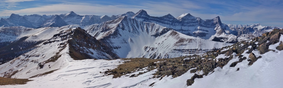
Can’t beat these views of the Kananaskis Range! Truly a panorama worth slogging for! From left to right: Fisher Peak, Mount Evan Thomas, Olympic Summit/Nakiska, Mount Kidd, Mount Kidd’s South Summit, the Fortress, Ribbon Peak, Mount Bogart, Mount Allan, Mount Sparrowhawk, Wind Mountain, Lougheed III, Mount Lougheed and Lougheed I. Click to see larger.
.jpg)
The four peaks of the Mount Lougheed massif beyond nearby Mount Allan.
.jpg)
The customary On-Top summit shot!
.jpg)
The steep walls of Mount Sparrowhawk (center) and Wind Mountain (right) beyond Mount Allan.
.jpg)
Looking beyond Collembola’s false summit towards pyramidal Mount Bogart.
.jpg)
A closer look at Mount Bogart – the second highest point in the Kananaskis Range; Ribbon Peak is also visible on the left.
.jpg)
The Fortress, Gusty Peak and Mount Chester are all visible in the distance.
.jpg)
Enjoying the Kananaskis Valley panorama while wondering how the ski hill parking lot got so far away…Click to see larger.
.jpg)
Looking across Highway 40 towards (from left to right): Tiara Peak (distant), Wasootch Peak, Kananaskis Peak, Mount Bryant (distant), Old Baldy Mountain, Mount MacDougall, Mount Howard (distant), Volcano Peak, Mount Glasgow (distant) and Fisher Peak. Click to see larger.
.jpg)
Crux soaks in the summit scenery.
.jpg)
Looking beyond Nakiska and Mount Kidd (right) towards the Opal Range (center).
.jpg)
A closer look revealing (from left to right): the Wedge, massive Mount Evan Thomas, distant Mount Pocaterra, tiny Limestone Mountain, Opal Ridge, Grizzly Peak, distant Mount Aosta and distant Mount Fox.
.jpg)
Crux enjoys a final moment of summit serenity before beginning the long scree bash/bushwhack/post hole journey back to the car.
.jpg)
After side-hilling about all obstacles on reasonably pleasant scree and carefully making our way down STEEP grassy slopes, a tired-looking Crux enjoys a brief break in the sun at Marmot Creek before re-entering the bush.
.jpg)
Hallelujah! Out of the bush and back on well-packed cross-country ski/snowmobile trails! From here, the car is only a “short” 4 km and 400 vertical meters away! Within an hour, a very tired Crux and I were all the way back down and on our way back home for dinner.
.jpg)
Told you he was tired (but then again, that was the point)! :-D
Suffice to say that Crux did not wreak any of his usual havoc at our "dinner" party (go Stamps go!) the following day!
.jpg)
.jpg)
.jpg)
.jpg)
.jpg)
.jpg)