A NOTE ON THE MOUNT ATHABASCA SCRAMBLE ROUTE: Mount Athabasca is an alpine objective which features several glaciers and big, potentially hazardous, terrain. The peak can be snow-covered year-round making it difficult to assess glacial margins and dangerous to ascend steep slopes. The scramble route which ascends gullies to the climber’s left of the AA col is extremely loose and exposed to significant rock fall hazard. When snowy, the route is subject to avalanches. Athabasca is not a scramble for beginners and, depending upon conditions, may not be a “scramble” at all. Before proceeding up Athabasca’s scramble route, I advise scramblers to:
• Be confident in their route-finding abilities on steep, loose terrain and able to manage rock fall (wear a helmet and travel in small groups).
• Know where the AA glacier starts and finishes. The margins of the glacier are often covered with rubble and difficult to identify.
• Know how to use crampons and an ice axe.
• Know how to assess current weather and avalanche conditions. Weather changes fast on big mountains and the Columbia Icefields are notorious for extreme cold, poor visibility etc.
• Know when to turn back. If you’re in over your head, don’t go further.
Towering above the Columbia Icefields visitor center, Mount Athabasca is a Canadian Rockies icon. The peak’s soaring rock walls bear numerous distinct hanging glaciers. Its remarkable grandeur and variety of routes make Athabasca a mecca for alpinists from near and far. Indeed, an ascent of Athabasca is often the highlight of introductory mountaineering courses. Wanting to build on my own mountain skill set and witness the Columbia Icefields as Normal Collie had in 1898, I signed up for a mountaineering course last summer. After completing the course curriculum on the nearby Athabasca Glacier, I was crushed when conditions on the peak were determined to be unsuitable as a result of hot weather and the ensuing rock fall hazard.
We peak baggers are obsessive types and more than a year later, the disappointment of that weekend still lingered and my desire to climb Athabasca continued to burn. Although the mountaineering course taught me the fundamentals of glacier travel, I’m more comfortable (and much more experienced) on scrambling terrain. As a result, I was intrigued by vague reports of a scramble-able route up Athabasca which had been circulating on a local hiking forum for years. My interest in Athabasca ramped up from slow burn to full-on ignited when I noticed that local alpine runner Tom Amaral had recently ventured up the rumored scramble route. Tom was good enough to provide me with some very up-to-date intel on the route and I longed for the opportunity to make an attempt.
While Athabasca was a priority for me, other more important matters were beginning to supersede it as the summer drew on; namely the birth of Brianne and I’s first child! With my future peak-bagger due at the start of October, I promised Brianne (and myself) that I wouldn’t be AWOL in the mountains as the big day approached. As the husband of a NICU nurse, I’m acutely aware that babies can come early! As the last week of August approached, I longed to cap off my summer scrambling season atop Athabasca. With clear skies forecast for Monday the 24th, I was able to get the day off work and find a willing partner (the equally mountain-obsessed Doug Lutz) to make an attempt. Following a sleepless night, I set off from Calgary at 3:30am and met Doug at the Columbia Icefields 3.5 hours later, eager to summit one last “big one” before the big day!
.jpg)
After enjoying crystal clear skies on Sunday, Monday dawned with thick smoke blanketing the Canadian Rockies. From the new climber’s parking lot (adjacent to the snowcoach road gate), Mount Athabasca could barely be seen! Unexcited by this unexpected development, Doug and I spent 10 minutes debating whether or not we should even bother to do anything (much less anything as significant as Athabasca).
.jpg)
Although mountaineers used to have access to a “climber’s parking lot” along the snowcoach road, the lot has since been repurposed by Brewster. With the new climber’s parking lot located just off Highway 93, we knew that we would have to walk an additional 2 km up (the previously drivable) snowcoach road. As you can see (with bikes in hand), we still walked up sections of the road but we had no intention of walking back down it at the end of the day!
.jpg)
Just before the snowcoach road steeply plunges down to the Athabasca Glacier, several cairned trails branch off onto glacial rubble. At this point, we ditched our bikes behind a suitable boulder and followed a sporadic trail up towards the AA glacier which separates Mounts Athabasca and Andromeda (photo courtesy Doug Lutz).
.jpg)
Fossil trilobites distract from the steep rubble.
.jpg)
I’ve seen many reports of climbers starting off with headlamps and losing this trail in the dark and now I know why – we lost it even in the daylight! Knowing that we needed to ascend to the climber’s left of the headwall below the AA glacier, we got a little too eager at one point and unnecessarily scrambled up steep, loose orange shale. As we worked our way towards the headwall on ledges, it became obvious that we’d need to lose some of this elevation in order to regain the trail. To stay on the trail, continue side-hilling below the orange shale ledges until you reach the gray scree slope shown here (in plain sight of the headwall and icefall).
.jpg)
Back on route and enjoying some fun moderate scrambling up ledges to the climber’s left of the headwall.
.jpg)
Pausing half-way up the headwall to enjoy the spectacular views of the icefall above and glacier below (photo courtesy Doug Lutz).
.jpg)
Once above the headwall, fresh snow made it tricky to tell where the edge of the AA Glacier was. From here, we avoided the temptation to follow the well-beaten path along the AA Glacier and started to sidehill up rubble on the left, working our way towards the back of the glacial cirque.
.jpg)
The rubble route well-above the AA Glacier.
.jpg)
Mount Andromeda rises steeply skyward across the broken surface of the AA Glacier. The Practice Gullies (several icy couloirs that are occasionally used to descend Andromeda) are visible on the left while the daunting “Andromeda Strain” line pioneered by Barry Blanchard, Dave Cheesmond and Tim Friesen goes straight up the crack in the center of the face. Click to see larger.
.jpg)
Doug continues to sidehill towards the scramble-able gullies (located directly under the rising sun in this photo). The AA col, frequently used by mountaineers to ascend/descend Athabasca, is the long avalanche-swept snow slope in the center of the photo.
.jpg)
Just about ready to be done with all this rubble sidehilling – at least the views are awesome (photo courtesy Doug Lutz)!
.jpg)
Looking up the gully that we finally decided to ascend. We aimed for the low point to the right of the gray rock buttress above, working our way up steep but moderate terrain as we went.
.jpg)
Fun scrambling! The terrain here is either loose rock or solid rock covered by loose rock (photo courtesy Doug Lutz)!
.jpg)
Doug makes his way up loose steps that drop steeply down to the crevassed AA Glacier below.
.jpg)
If you think the terrain here looks unpleasant, check out the Practice Gullies behind and to the right (photo courtesy Doug Lutz).
.jpg)
About half-way up the gully, the terrain begins to open up above. Once we reached the more open terrain, we worked our way diagonally up to the right towards the AA col (photo courtesy Doug Lutz).
.jpg)
Kicking steps up the steep snow-covered slope towards the AA col (photo courtesy Doug Lutz).
.jpg)
Doug literally follows in my footsteps. On ascent, we were blessed with a perfect boot-deep punch crust which proved very easy to kick steps into. I was, however, concerned about descending this same slope later in the day when I expected that the sun would turn it into a slushy soup…
.jpg)
After working our way diagonally up across the open slope, we scrambled up a brief gully before topping out to spectacular views on Athabasca’s northwest ridge. Here, I sat and rested until feeling returned to my frozen toes while Doug explored some high points along the ridge on the right. Click to see larger and see if you can spot the crazy man.
.jpg)
Doug enjoys an airy but spectacular perch. Mouse over for a closer look.
.jpg)
A breathtaking view of Mount Andromeda. The gully that we scrambled up is visible below and on the right while a set of tracks leading to the AA col is just visible on the left.
.jpg)
An impressive bergschrund at the base of the Practice Gullies.
.jpg)
Poser (photo courtesy Doug Lutz).
.jpg)
The remaining snow/scree slog up Silverhorn (Athabasca’s false summit) (photo courtesy Doug Lutz).
.jpg)
The mountain ain’t gonna climb itself…
.jpg)
Ascending the rocky ridge towards Silverhorn.
.jpg)
Doug follows as more expansive views of the Columbia Icefield open up behind us.
.jpg)
Above 11,000 feet the air started to get a little thin for Doug (either that or the 2,200 m of elevation gain that he did the day prior is starting to catch up with him)!
.jpg)
On top (of Silverhorn anyways)! From the summit of Silverhorn, the final arête leading to the summit of Mount Athabasca is spectacularly revealed!
.jpg)
Glaciers cascade off peaks in steep icefalls and litter the valleys all about. This must have been what Normal Collie was talking about 117 years ago! Click to see larger.
.jpg)
Adjacent Mount Andromeda’s east face is highlighted by extensive glaciation and an impressive icefall.
.jpg)
Mount Saskatchewan is faintly visible across the low-lying Saskatchewan Glacier through the smoky skies to the southeast.
.jpg)
Gearing up for the final glacier-abutted ridge.
.jpg)
Seeking to avoid exposure, I opted to traverse just below the steepest section of the snow arête rather than tackling it head-on. This was a mistake as the slopes that I traversed were south-facing and steep (not a good combination when they’re comprised entirely of snow) (photo courtesy Doug Lutz)!
.jpg)
Doug comes straight up the arête (as I should have) as the Little A Glacier drops steeply away below. Click to see larger.
.jpg)
An intricately engineered cairn marks our arrival atop massive Mount Athabasca! Click to see larger.
.jpg)
Looking beyond the tripodal cairn towards tiny Castleguard Mountain and the three high peaks of Mount Bryce (faintly visible through the smoke).
.jpg)
The breathtaking views (and drop) to the south.
.jpg)
A closer look at the impressive icefall which tumbles down Mount Andromeda’s east face.
.jpg)
“Brothers everywhere, raise your hands into the air!”
.jpg)
Mount Columbia (3,747 m), the highest peak in Alberta and second highest in the Canadian Rockies, makes a smoky appearance beyond the twin summits of Mount Andromeda (3,450 m).
.jpg)
The thickness of the icefield is obvious atop Snowdome (left) and Mount Kitchener (right). Snowdome (3,451 m) is North America’s only triple continental divide. Snow and ice from its summit can melt into any one of the 3 oceans surrounding our continent (Pacific, Atlantic and Arctic). Beyond Snowdome and Kitchener, the North Twin (3,730 m) and Twin’s Tower rise up in the distance. North Twin is the third highest peak in the Canadian Rockies. If you’re starting to get the impression that the mountains surrounding the Columbia Icefield are big, you’re right! 11 of the 22 highest peaks in the Canadian Rockies are found in this area!
.jpg)
A massive cornice obscures the views to the north from Mount Athabasca’s summit. Suffice to say, we didn’t climb it and were happy to enjoy the views to the east, south and west!
.jpg)
After enjoying the views from the summit, we began to retrace our steps back down the arête. While we could have spent hours on the summit, we wanted to get down before the snow on our ascent route softened too much in the afternoon sun. On ascent, I foolishly avoided the arête. Fortunately, I was smart enough to stick to its crest on descent (mouse over to see).
.jpg)
Doug looks for a little extra challenge while re-ascending Silverhorn.
.jpg)
The summit panorama from Silverhorn may actually have been better than that from Mount Athabasca since there was no cornice obstructing the views to one side! From left to right: Mount Andromeda, Mount Columbia (distant and smoky), Snow Dome, North Twin (distant and smoky), Mount Kitchener, Stutfield Peak, the Sunwapta River, Tangle Ridge (distant and smoky), Mount Wilcox and Sunwapta Peak (distant and smoky). Click to see larger.
.jpg)
An impressive glaciated rock fin extending to the northwest from Athabasca.
.jpg)
Melt water from the famous Athabasca Glacier collects in Sunwapta Lake before beginning its long journey to the Arctic Ocean.
.jpg)
Looking down the North Glacier from Silverhorn towards tiny Boundary Peak and Nigel Peak across the highway (both center left).
.jpg)
Hilda Peak (right) rises up above a colorful tarn which collects run-off from the Boundary Glacier.
.jpg)
Despite the smoke, the views really were spectacular! Thank God that so many of the peaks in this area are large enough to stand above the smoke which blanketed many of the valleys below! Click to see larger.
.jpg)
Last glimpses of Athabasca’s majestic summit.
.jpg)
A final Silverhorn (false) summit shot before embarking on our descent. Click to see larger (photo courtesy Doug Lutz).
.jpg)
Doug crosses a small bit of glacier/snowfield on a beaten trail to get back to our ascent/descent gully.
.jpg)
Looking down our steep ascent/descent gully.
.jpg)
Doug leads the way down the open snow slope. I had been really concerned about descending this steep slope in slushy afternoon conditions but, fortunately, the snow wasn’t deep enough to slide and the scree underneath had melted allowing for relatively easy plunge stepping.
.jpg)
Easy does it as the terrain in the gully steepens.
.jpg)
Descending typical moderate terrain (photo courtesy Doug Lutz).
.jpg)
Classic five-point descent technique (2 arms, 2 legs and 1 ass) (photo courtesy Doug Lutz).
.jpg)
Sadistic side hilling. Once we were down the bulk of the gully, we stayed high above the AA Glacier and aimed towards the northern edge (skier’s right) of the headwall.
.jpg)
This stream at the base of the AA Glacier was not flowing nearly as vigorously earlier in the day!
.jpg)
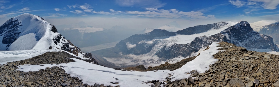
Looking down from the top of the steep headwall towards the lower section of the AA Glacier and the Athabasca Glacier. If you look closely, you can make out a couple of tiny snowcoaches on the Athabasca Glacier below.
.jpg)
Pausing to enjoy the spectacular views of the AA Icefall as we work our way down the headwall on moderate ledges.
.jpg)
Back at the bikes! From here on, the descent was VERY rapid as we blazed past sluggish snowcoaches at speeds up to 65 km/hour – WOOHOO!
.jpg)
A cold beer and an awesome view of Mount Athabasca - can there be any finer finish to a big day? Indeed, Mount Athabasca proved to be the perfect climax to my 2015 scrambling season and was well-worth the year-long wait following the disappointment of my glacier course last summer. With Athabasca behind me, I can focus on looking forward to the birth of Brianne and I’s beautiful baby girl. I can’t wait to take both of them up this Canadian Rockies icon someday!
.jpg)
.jpg)
.jpg)
.jpg)
.jpg)
.jpg)
.jpg)
.jpg)