With Brianne in the final weeks of her pregnancy, I was officially placed on full-time “Baby Watch.” For many men, this means having hospital bags packed and being ready to rush to L&D on short notice. For me, this meant not venturing too far from Calgary or beyond cell phone reception while peak bagging! Aiming to take advantage of perfect September weather, I hoped to find a modestly grandiose target which fit the requirements outlined above. As I brainstormed, I recalled outstanding scenery and (more importantly) outstanding cellular coverage from base to summit during an ascent of Mount Allan years earlier. With Crux in tow this time (and on the hunt for his 60th summit), I made my way back to the Ribbon Creek trailhead to revisit “one of the most wonderful ridge walks in the Canadian Rockies.”
.jpg)
From the parking area, we followed the Centennial Ridge trail north and turned left at the first signed junction. Despite a multitude of forks along the trail network in this area, it would be difficult to get lost thanks to obvious signage. Only the sign at the first junction is lacking (thanks to the repeated pointing of cross-country ski poles). Beyond this junction, the Centennial Ridge trail is very well-marked and the signs even provide an indication of the upcoming ascent grade. Mouse over to see how the signs change as the grade steepens (and it does STEEPEN)!
.jpg)
After an hour of hiking through the forest, we reached the tree line and were greeted by expansive alpine views. What a perfect day to be in the mountains! Click to see larger.
.jpg)
Have I mentioned that the hike up Olympic Summit is STEEP? Even well-conditioned scramblers (like Crux) will find themselves out of breath!
.jpg)
Nearing the top (of Olympic Summit anyways). The buttress ahead is the last major elevation gain required in order to gain Centennial Ridge (which runs from Olympic Summit up towards Mount Allan). Click to see larger.
.jpg)
A good path switchbacks up amongst the larches on the right-hand-side of the buttress.
.jpg)
As steep as the going gets – strenuous hiking to be sure but no hands-on scrambling is required to scale Olympic Summit.
.jpg)
The sheer rock walls of Mount Kidd provide a stark contrast to the rolling alpine meadows above the buttress. From this point on, the ascent angle eases and the trail gently makes its way over a series of small bumps before reaching Olympic Summit.
.jpg)
Mount Sparrowhawk towers above a pair of ptarmigans (who are so well camouflaged that we nearly tripped over them!).
.jpg)
The Nakiska ski hill falls away at our feet. The Gold Medalist at the 1988 Olympics (Pirmin Zurbriggen) made it all the way down to the valley from here in under 2 minutes!
.jpg)
A carpet of larch trees runs towards Mount Collembola, signaling the changing of the seasons with their golden hue.
.jpg)
From Olympic Summit, the sheer east face of the Kananaskis Range is beautifully revealed as Centennial Ridge stretches off towards our ultimate objective on the far right. From left to right: Mount Kidd, Mount Kidd South Summit, Mount Galatea, Ribbon Peak, Mount Bogart, Mount Sparrowhawk, Wind Mountain, Mount Lougheed and Mount Allan. Click to see larger.
.jpg)
Following a speedy 2 hour ascent, I took a well-earned photo/food break atop Olympic Summit. As per usual, Crux did not object to a rest stop.
.jpg)
Mount Sparrowhawk was also proposed as a possible venue for the Olympics.
.jpg)
From Olympic Summit, snowy Mount Allan is still 400 m higher and 2.5 km away.
.jpg)
“What do you mean we have to keep going? I thought this was the summit!” Poor Crux didn’t realize that he’s signed up for a two’fer!
.jpg)
On the road again: making our way through Centennial Ridge’s scenic “rock garden.” Click to see larger.
.jpg)
What began with the occasional scenic boulder eventually ended with a series of towering monoliths reminiscent of a Rocky Mountain Stonehenge. Click to see larger.
.jpg)
A rocky frame for pyramidal Mount Bogart.
.jpg)
The “rock garden” provides endless possibilities for photography. Needless to say, our progress here was slow as I burned through an impressive amount of digital memory.
.jpg)
Approaching the crux of the day. Cairns and a white sign mark the Centennial Ridge trail as it descends some steeper terrain to the left (west). This descent involves some easy scrambling which should pose little problem for 2-legged hikers. It may not, however, be friendly for 4-legged hiking companions like Crux. Fortunately, there’s an easy by-pass below boulders to the right (east) just before this point. Mouse over for a look at the dog-friendly by-pass.
.jpg)
Crux tackles the steep crux. If your dog is light enough to easily lift down some larger rock bands, this route may be perfectly fine. Crux is, however, a chubosaurus! We managed to chart a course down this section by zig-zagging from ledge to ledge but on our return trip, we simply by-passed this whole section on grassy terrain to the east (see previous photo).
.jpg)
Beyond the “rock garden,” the remainder of the ascent is a simple scree slog. Ignore the path which traverses the face to the left unless you’re a sheep or goat. To get to the summit, simply follow another good path which stays very near the ridge crest all the way up!
.jpg)
Mount Sparrowhawk and Wind Mountain loom large as you near the top.
.jpg)
Crux enjoys a final snowy respite from the ascent just below the summit. C’mon boy!
.jpg)
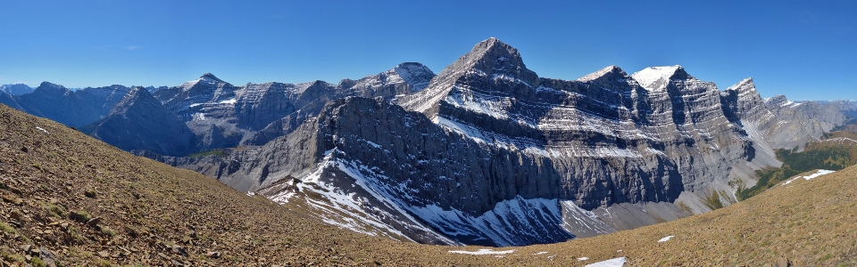
One of the finest panoramas offered by a hike in the Canadian Rockies! With a summit elevation of 2819 m, the hike up Mount Allan is the highest maintained trail in the Canadian Rockies. Mount Kidd, Ribbon Peak, Mount Bogart and Mount Sparrowhawk highlight the view to the left while the 4 peaks of the Mount Lougheed massif tower above all else on the right. Click to see larger.
.jpg)
A good boy atop his 60th summit!
.jpg)
Crux and I on top of Mount Allan.
.jpg)
Great views of Ribbon Peak and Mount Bogart.
.jpg)
A closer look at Bogart’s snowy summit pyramid.
.jpg)
The Bogart Tower and Memorial Lakes.
.jpg)
Mount Sparrowhawk and Wind Mountain.
.jpg)
Mount Lougheed (II – right, III – left).
.jpg)
An impressive cirque separates Mount Allan from nearby Mount Collembola (right). Ultimately, this cirque descends all the way to the Bow Valley and Canmore to the north. Click to see larger.
.jpg)
Lougheed I’s sharp summit (left) highlights the view towards Canmore and Banff.
.jpg)
A closer look at Canmore icons the Three Sisters (left) and Banff icon Mount Rundle (right).
.jpg)
Snowy Mount Aylmer rises up beyond the Fairholme Range and Canmore. Thank a Lafarge cement plant for the extensive scar obvious along the base of Grotto Mountain.
.jpg)
Front Range peaks (like Orient Point, Morrowmount, End Mountain, Association Peak and Yamnuska) stretch out above the prairies beyond grassy Pigeon Mountain (left) and rocky Mount McGillivray (right).
.jpg)
Mount Collembola was another one of Crux’s favorites!
.jpg)
A fine panorama of the Kananaskis Valley to the east. From here, Olympic Summit and Nakiska (center right) look surprisingly insignificant. Click to see larger.
.jpg)
Golden larches dot Nakiska’s slopes as Wasootch Peak rises up on the far side of the valley.
.jpg)
The Calgary skyline is faintly visible beyond the twin summits of Midnight Peak.
.jpg)
The expansive panorama of the Kananaskis Range is undoubtedly the highlight of Mount Allan’s summit views. From left to right: Mount Rae (distant), the Opal Range, Mount Kidd, Mount Kidd South Summit, Mount Inflexible (distant), Ribbon Peak, Mount James Walker (distant), the Fortress (distant), Mount Bogart, the Bogart Tower, The Tower (distant), Mount Sparrowhawk and Wind Mountain. Click to see larger.
.jpg)
One last summit selfie before starting our descent. If you use 2 cars, you can descend Mount Allan’s north ridge to Dead Man’s Flats. Since Crux doesn’t drive, however, we had only 1 car and had to go back down the same way we came up!
.jpg)
Starting off down Centennial Ridge’s scenic spine.
.jpg)
Crux looks like he’s stopping to enjoy the fall colors but he’s not. He can’t distinguish yellow from red or green because he’s a dog. Click to see a larger version of what poor Crux can’t.
.jpg)
Approaching “Stone Henge” and the only bit of scrambling. The trail (and the scrambling) is off to the center right here. In the interest of simplicity, Crux and I opted to by-pass just below the boulders to the left before regaining the trail along the ridge crest.
.jpg)
♪ "Where the demons dwell and the banshees live (and they do live well)…" ♪
.jpg)
The ascent of Olympic Summit from this side is considerably easier, involving only 40 m of elevation gain.
.jpg)
Snowy Fisher Peak highlights the view as we follow the yellow brick grass road down.
.jpg)
Final stunning views of Ribbon Peak and Mount Bogart before plunging into the valley below on Olympic Summit’s steep grass slopes.
.jpg)
My poky partner casually descends. In fairness to Crux, the temperature lower down was 30 degrees – not ideal for a black puppy who’s had a strenuous day! As the heat and September sun took their toll on poor Crux, we started to take breaks every 5 – 10 minutes until his panting sounded less dire.
.jpg)
Salvation in the form of Ribbon Creek! After a quick creek cool-off, Crux and I rushed back to Calgary to see if he was a big brother yet. Alas, he was not and our “Baby Watch” continues!
.jpg)
.jpg)
.jpg)
.jpg)
.jpg)
.jpg)
.jpg)
.jpg)
.jpg)
.jpg)