Having admired Matt Clay’s scrambling and hiking website for some time, I noticed that he’d been making more midweek ascents recently; Matt is a chemistry professor and, with classes out for the summer, is now free to escape to the mountains when normal folk are stuck at work. While my own work arrangements aren’t as flexible as Matt’s, I am lucky enough to have every second Friday off. With an eye towards bagging a peak in good company on my day off, I reached out to Matt and was pleased when he accepted my scrambling invitation. After debating a couple of potential targets, Matt suggested Morrowmount and I agreed that the peak looked interesting (naively ignoring the fact that its ascent would require us to boulder-hop 9 km up and then 9 km back down a tedious creek bed). Alas – ‘tis better to suffer with a friend than to suffer alone!
.jpg)
Departing from Calgary at 6:45am, we quickly left the rush hour commuters behind en route to the Jura Creek/Door Jamb Mountain trailhead pullout just east of Exshaw. From the trailhead, views of Mount McGillivray through the morning fog hinted at a scenic day ahead.
.jpg)
After following a dirt road/ATV track west for 5 minutes, we reached Jura Creek and started our long plod towards its headwaters some 9 km to the north.
.jpg)
The initially wide creek bed quickly narrows and we soon found ourselves surrounded by water-worn walls in an interesting slot canyon.
.jpg)
Holy walls closing in on you Batman!
.jpg)
After leaving the first slot canyon behind, an unremarkable plod brought us to this interesting notch-like geological feature. This notch is actually part of the McConnell thrust where blackened shale from the Exshaw Formation meets gray limestone from the Palliser Formation. While the gray rocks on the east of the notch were deposited in a shallow tropical sea, the black shale to the west formed in a deep stagnant environment which allowed for hydrocarbon formation; as a result, the Exshaw formation is an important source rock for many of Alberta’s oil and gas reserves.
.jpg)
Small pools of water collect in the upper canyon.
.jpg)
Beyond the upper canyon, the creek bed widened and damage from the 2013 floods became more apparent. It also became apparent that we would be dealing with more snow than expected thanks to a storm the night prior; fortunately, the only thing more fun than boulder-hopping is slippery snow-covered-boulder-hopping!
.jpg)
Still a long ways to go! We won’t be leaving Jura Creek until the base of the peak in the distance. From here, the summit of Morrowmount is just visible above the trees to the right of the obvious peak at creek’s end.
.jpg)
Are you sick of Jura Creek yet? We sure were! Fortunately, Matt and I have plenty in common (name, PhD in chemistry, obsessive peak bagging); good conversation is key to surviving this approach!
.jpg)
Maybe bushwhacking will be better than the creek? Jury’s still out on that…at least it was different!
.jpg)
Morrowmount’s gray slabby face finally comes into view. The proper route follows the ridge on the left up, however, Matt and I decided to see if we could escape the creek a little earlier by ascending the scree slope on the right. Unfortunately, after slogging up 150 m it became apparent that this route wouldn’t go. Sheepishly, we retreated back down and resumed our plod up the creek…
.jpg)
Matt marks the spot (a confluence of 2 different creeks)! THIS is where you should finally leave Jura Creek to ascend Morrowmount! From here, we bashed our way up the orange scree towards the obvious break in the cliffs above on the left. Note: as you may surmise from the sudden lack of snow, this photo was actually taken on descent; on ascent, we still didn’t know for sure that THIS was the spot!
.jpg)
One step up, two slips down. The ultra-smooth dinner plate-like scree on this steep slope proved quite greasy when covered in snow…later on, when the snow melted, we could see what we’d actually been dealing with (mouse over).
.jpg)
Slip and sliding his way up a steep snowy slope, Matt wonders “Whose idea was it to climb this mountain anyways?” It was yours Matt; all yours! ;-)
.jpg)
After easily hiking up through the rock band, Morrowmount’s upper slopes and twin summits finally came into view. Although the right-hand (south) summit looks higher from here, the 2 summits are essentially equal in height (rumor has it that the north summit may actually be 1 meter higher).
.jpg)
Having at last left the confines of the creek, the more open slopes of the upper mountain finally granted us a panorama of the peaks surrounding Jura Creek. On the left, Morrowmount’s slabby west face and the distinctive shape of Hassel Castle tower above while Exshaw Ridge and Mount Fable highlight the view to the right. Click to see larger.
.jpg)
A closer look at Hassel Castle’s unique summit block; reminds me of a humpback whale from this angle!
.jpg)
The final slog to the summit. Unlike earlier slopes, the snow here was just deep enough to actually make our lives a little easier…that is until we found the slabs. I say “found” because they were well-hidden under snow; you didn’t know you were on one until you slipped and fell face-first into the mountainside! Fortunately, all of the slabs that we “found” were only 2 – 3 m high and we were able to carefully crawl/claw our way up them.
.jpg)
A grinning Gollum/goblin(?) enjoying the strong summit sunshine (I didn’t enjoy the subsequent sunburn nearly as much).
.jpg)
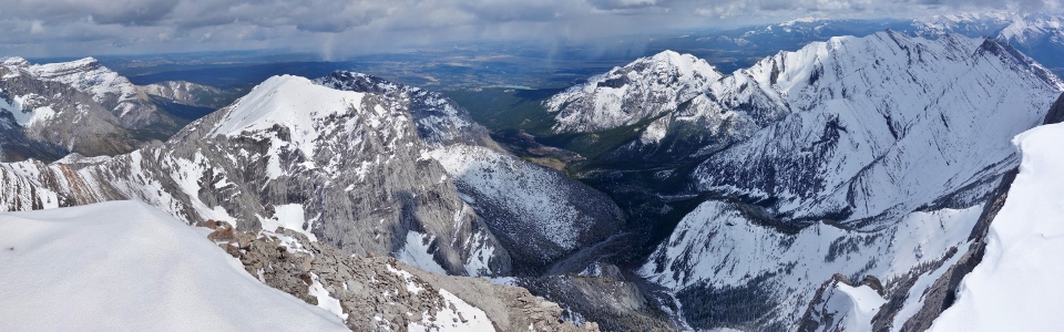
A precipitous drop to the east of the summit provides an outstanding panorama of the CMC Valley below and the prairie flat lands beyond. From left to right: End Mountain, Association Peak, tiny Association Hill, Mount Wendell, the East Peak of Wendell (EPOW), Yamnuska (Mount John Laurie), Old Goat Mountain and Hassel Castle. Click to see larger.
.jpg)
Looking south along the long ridge connecting Morrowmount to Hassel Castle and Old Goat Mountain.
.jpg)
Yamnuska at the end of the CMC Valley.
.jpg)
Our unusual vantage point granted good views of the entire Yamnuska scramble traverse.
.jpg)
Snow-capped Mount Wendell and the slightly lower EPOW bask in the sunshine while rain showers are scattered across the prairies beyond.
.jpg)
Great views of the End Mountain/Association Peak massif.
.jpg)
Trying out a less goblin-like summit pose this time. If I look any brighter than usual, it’s because my wife made me wash my hiking jacket…something about it being gross that I hadn’t washed it since I got it 3 years (about 100 summits) ago.
.jpg)
The panorama west beyond Exshaw Ridge towards Mount Fable (center) and Mount Townsend (right). Click to see larger.
.jpg)
Looking south into Kananaskis Country; from left to right: Mount McGillivray, Mount Kidd, Mount Collembola, Mount Allan, Wind Mountain, Pigeon Mountain, Mount Lougheed, the Windtower and Mount Nestor.
.jpg)
Distant K-Country peaks dot the southern horizon. From left to right: Windtower, Mount Soderholm (distant), Mount Nestor, Goat Mountain, Rimwall Summit, Gap Peak, the Orphan, the Three Sisters, Eon Mountain (distant) and Aye Mountain (distant).
.jpg)
Looking north towards Morrowmount’s other summit and more remote peaks scattered about the Ghost Wilderness. From left to right: the Three Sisters, Grotto Mountain, Mount Fable, the long rising ridge of Mount Townsend, South Ghost Peak and Orient Point. Click to see larger.
.jpg)
Mount Fable’s spectacularly steep east face.
.jpg)
Looking along Morrowmount’s summit ridge towards Orient Point and the prairies.
.jpg)
A closer look at Orient Point.
.jpg)
One last summit photo of Matt Squared before starting the long descent.
.jpg)
Easy plunge stepping down the upper slopes (except for a couple of wet slabby bum slides).
.jpg)
Spectacular views of Hassel Castle on descent.
.jpg)
Matt makes his way down some loose but easy terrain as we work our way back down through the rock bands.
.jpg)
Melting snow on Morrowmount’s slabby face creates an impromptu 600 vertical meter waterfall.
.jpg)
Scree salvation! With the morning snow melted, we were treated to wonderful scree run back down to Jura Creek.
.jpg)
Bracing ourselves for 2.5 hours of rock-hopping as we return to creek level.
.jpg)
Looking back towards Morrowmount (just right of center); feet getting sore…
.jpg)
Jura Creek panorama. Morrowmount (far left) is but a distant memory while our exit point is still miles ahead (far right). In between, nothing but an immense “rubble fuck” (credit to Matt for coining the most appropriate term imaginable to describe Jura Creek). Click to see a larger rubble fuck.
.jpg)
Jura Creek’s lower canyon was a welcome sight as from here, the end was near! When taking on an approach like Jura Creek, good company is essential and, at the risk of sounding narcissistic, the company of peak-bagging chemists named Matt is amongst the best.
.jpg)
.jpg)
.jpg)
.jpg)
.jpg)