Littler Galatea
Elevation: 2550 m
Elevation Gain: 730 m
Little Galatea is a minor highpoint which sits at the south end of the Mount Galatea massif. Like other peaks in the area, Mount Galatea was named for a warship involved in the Battle of Jutland (WWI).
My Ascents:
December 27 2015
Trailhead: Rummel Lake Trailhead (Roadside)
GPS Track: Littler Galatea
As the 2015 holiday season approached, fellow Matt/scrambler/chemist Matt Clay reached out to see if I might be interested in joining him for a snowshoe outing. Having last stood upon a new summit 121 long (but enjoyable) days ago, I was eager to get back to the mountains so that I could discover just how out of shape fatherhood has made me! With high hopes for spectacular scenery, Matt, Crux and I set out for Kananaskis Country, aiming for a peak along the continental divide. Unfortunately, as we made our way west from Calgary, it became obvious that the divide was completely socked in. Although thick clouds covered many of the surrounding peaks, we noticed a large “suckerhole” above Little Galatea. Although we doubted that this tiny patch of sunshine would persist, we decided that it looked better than other overcast alternatives nearby! Although Nugara’s guidebook describes a snowshoe route up Little Galatea via Chester Lake, Marko Stavric outlined a potentially safer route via Rummel Creek some years ago. With a vague recollection of Marko’s route, Matt, Crux and I set out from the popular Rummel Lake trailhead (across the highway from the Engadine Lodge) to see if we could find some sunshine under which to climb a mountain (or at least an outlier thereof)!
.jpg)
Early morning views of the Fist and Tent Ridge (complete with Space Command Center!) from the sparsely treed lower slopes just above the Spray Lakes highway.
.jpg)
Mount Engadine rises sharply above as Matt powers up the well-travelled trail to Rummel Lake.
.jpg)
The Little Galatea exit: after about 3 km, the Rummel Lake trail makes a 90 degree turn to the left and descends to Rummel Creek. Continue straight ahead into the bush for Little Galatea.
.jpg)
Pleasant winter scenery as we ascend gentle (for now) slopes.
.jpg)
Getting steeper…and deeper! While those on snowshoes had little trouble ascending the steepening slope, poor Crux spent a lot of energy post-holing his way up.
.jpg)
Steeper still…by this point, the somewhat supportive snowpack had degenerated to meter-deep unconsolidated sugar. As we continued upwards, the forest echoed with grunts and curses as we all pawed hopelessly at the steep, loose snow. Frequent glances at my altimeter confirmed that we weren’t getting anywhere fast, travelling at about 1/4 of my usual summer pace.
.jpg)
Eventually, we reached the first of several open areas on Little Galatea’s northwest ridge. These glades were steep enough to slide so we contoured around their upper edges to mitigate the risk of avalanche.
.jpg)
Open glades provide us with our first good views of the cloudy great divide to the west – good thing we didn’t wander into the pea soup over there!
.jpg)
Once we broke the tree line, we were greeted by sunshine, open slopes and spectacular views thanks to the ever-expanding “suckerhole” we opted to climb beneath.
.jpg)
Above the trees, in the windswept alpine, upwards travel was much faster and we soon found ourselves on the ridge crest with wonderful views towards Rummel Pass.
.jpg)
A substantial cornice conceals the vertiginous drop to Rummel Lake. Beyond the lake, Mount Engadine, the Tower and Mount Galatea (left to right) shed plumes of cloud into the blue winter sky. Although it looks massive, the peak closest to the right is actually a false summit on the Galatea massif.
.jpg)
A closer look at Mount Galatea: the highest peak in the Kananaskis Range.
.jpg)
Looking along the narrow, corniced ridge towards Little Galatea.
.jpg)
Crux and I caught up to the speedier Matt at the first sub-peak along the ridge (looks like the new dad and his dog need more exercise). Beyond this point, he’d already been turned back by a steep, hard snow slope. Although Matt was willing to give the slope another go, the dog walk along the narrow, corniced ridge had already made me weary. Crux loves snow and I essentially had to short-rope him the entire way along the ridge crest to keep him off of the cornice.
.jpg)
Concerned that I’d lose Mr. Crux to the abyss beneath the cornice, Matt and I, therefore, decided to call it a day at the sub-peak. Normally, I wouldn’t count a sub-peak as a summit but, realistically, Little Galatea is itself a sub-peak of a sub-peak of Mount Galatea. I figured there wasn’t much difference between that and the sub-peak of a sub-peak of a sub-peak of Mount Galatea (that and I don’t plan to come back to finish this ascent later)! One could argue that our sub-peak (Littler Galatea) shouldn’t count as a summit but what is beyond reproach is the fact that our final stop featured a spectacular view!
.jpg)
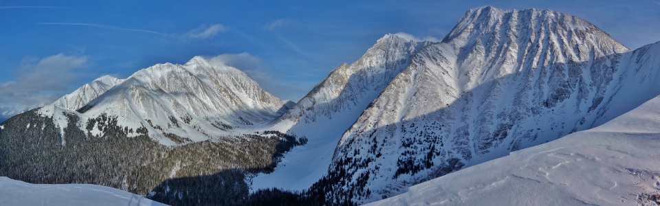
The panorama of the divide to the west is made all the more spectacular by our position at the epicenter of an expanding “suckerhole”! For once, it was nice not to be made a sucker of in these conditions! Click to see larger.
.jpg)
Silhouettes of the British Military Group are revealed as the clouds begin to break along the divide. From left to right: Mount Murray, Mount French, Mount Robertson, Mount Sir Douglas, Mount Burstall and Whistling Rock Ridge.
.jpg)
Commonwealth Peak (left) and Pig’s Tail (right) rise above Commonwealth Ridge and Pig’s Back, respectively. All are dwarfed by massive Mount Birdwood (right).
.jpg)
The Fist, Tent Ridge and Mount Shark appear across the highway. More distant Mounts Smuts and Assiniboine are also faintly visible through the cloud (left and right, respectively).
.jpg)
The view back down the ridge towards Rummel Creek and Spray Lake.
.jpg)
Crux enjoys the view from his narrow “summit” perch.
.jpg)
Following a brief summit stay (there wasn't much room to maneuver for photos!), Matt led the way back down the ridge to our ascent track.
.jpg)
Crux stares longingly at the cornice (and its seemingly easier travel) while I attempt to keep him on rougher ground well below it (photo courtesy Matt Clay).
.jpg)
Since the sub-peak summit was too tiny for photos, Crux and I stopped for our obligatory summit photo together on the way down (photo courtesy Matt Clay).
.jpg)
Last views of Rummel Lake and the Tower before plunging back into the unconsolidated powder below.
.jpg)
Sometimes you break the trail and sometimes the trail breaks you! The post-holing puppy takes one of many hard-earned breaks on descent.
.jpg)
With occasional prodding and constant encouragement, Mr. Crux, Matt and I eventually made it back to the hard-packed Rummel Lake trail. From here on, travel in the fading light of our all-day “suckerhole” was fast and easy.
.jpg)