With a Friday off work and a favorable weather forecast, Crux and I had ambitious plans to take advantage of some spectacular winter scenery along the continental divide in Kananaskis. With the sun creeping higher in the sky now that it’s April, we were out of bed at 4:30 am and out of the house by 5:30 am in the hopes of avoiding afternoon sun on potential avalanche slopes. By starting early, we also hoped to avoid the dreaded isothermal snow that plagues the Rockies on warm afternoons this time of year!
.jpg)
A handsome reward for an alpine start: sharing spectacular sunrise views of Mount James Walker (left) and the Fortress (right) with a herd of elk on the side of Highway 40 (Kananaskis Trail)!
.jpg)
As Crux and I made our way beyond the elk and further into the mountains, I was ecstatic to see brilliant blue skies over snow-capped peaks! Views, like this one of Mount Fox, Mount Foch and Mount Sarrail in the early morning light, prompted me to pull over for photos at regular intervals. Small wisps of cloud over the continental divide, however, made me somewhat uneasy. Perhaps it’s just the eternal pessimist in me, but I had a strong feeling that those wisps would turn to whiteouts by the time that I got up my intended objective.
.jpg)
Pulled off to the side of the highway, admiring the view and wondering if the weather over the divide would deteriorate, I noticed that nearby King Creek Ridge appeared to be almost completely snow-free (side note: appearances can be deceiving). Trusting my gut, I made the snap decision to attempt this more proximate objective. In addition to posing little avalanche risk in its current state, I reasoned that the lack of approach would have me up and down this peak before the weather had time to foil my views!
.jpg)
Only moments beyond the highway, the small trail on the north side of King Creek splits. Initially, I followed the left-hand branch since it appeared to be more well-travelled. This branch quickly entered the woods and proceeded to side-hill unnecessarily (in my opinion anyways). Tiring of the trail going horizontally and not vertically, I made my way back to the south end of King Creek Ridge and rejoined the right-hand branch of trail. While this fainter trail was harder to follow, it was aiming in the proper direction (up!). With the benefit of the Kananaskis Country Trail Guide as I write up my trip report, I now know that either trail will work. The left branch is a newer “West Flank” trail while the right branch is the older “South Southeast Ridge” trail. Despite the sometimes-confusing proliferation of trails on King Creek Ridge, they should all make their way to the top eventually!
.jpg)
Crux enjoys some paws-on scrambling! Actually, the South Southeast Ridge trail cleverly weaves its way up any small rock bands which it encounters. Although Crux needed to use all fours to get up, most human hikers should be able to handle this route with their hands in their pockets.
.jpg)
Thanks to our early start, we spent the first couple of hours of the ascent in the shadow of the Opal Range.
.jpg)
King Creek Ridge may be small but it’s steep! Fortunately, views of sun-kissed Mount Wintour (left) and the more distant Kananaskis Lakes (right) provided a wonderful excuse to pause for a breather!
.jpg)
A closer look at the Kananaskis Lakes in the valley below Mounts Aosta, Fox, Foch and Sarrail. Mount Joffre (right) is also faintly visible in the building cloud beyond Sarrail.
.jpg)
Steep and rocky east faces glow in the early morning light to the west. From left to right: Mount Aosta, Mount Fox, Mount Foch, Mount Sarrail, Mount Indefatigable, Mount Invincible, Mount Putnik (distant) and Mount Warspite. Click to see larger.
.jpg)
After a cool ascent in the shadow of the Opal Range, we reached the ridge crest as the sun finally eclipsed Mount Blane and the Blade (a sharp outlier of Blane).
.jpg)
Although the ascent to the ridge crest had been largely dry, the ridge crest itself was still buried under knee to crotch-deep snow. From this point on, I was very thankful that I’d bothered to haul my snowshoes up despite the fact that the ridge looked bone dry from below!
.jpg)
Pleasant views of Mounts Blane (left) and Burney (right) from King Creek Ridge’s snowy crest. Thanks to our early start and a good overnight freeze, the snow was quite icy! Again, the snowshoes (with their built-in crampons) made life much easier.
.jpg)
One more reason to be glad that I brought the ‘shoes! The ridge was littered with some poor previous hiker’s post holes. From the looks of things, this poor individual gave the ridge a good go in boots, enduring what must have been a complete suffer-fest in isothermal snow. Sadly, the tracks ended before the summit.
.jpg)
Continuing along the ridge, the summit comes into view. While I’m sure that there’s an easy-going trail up this ridge in the summer, I found that the icy snow added a little spice to our ascent as the ridge narrows at several points with steep slopes to each side; not particularly exposed but a slip could be unpleasant nevertheless!
.jpg)
Matt eats summits for breakfast (or at least eats breakfast on summits). Thanks to an alpine start, Crux and I arrived on the summit of King Creek Ridge at 9:30 am. The timing would have been perfect for some eggs and bacon but, alas, all I brought was PB&J.
.jpg)
It’s never too early for Crux’s first nap of the day!
.jpg)
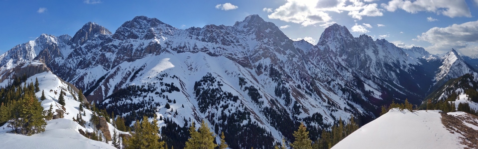
The summit of King Creek Ridge features an awesome panorama of the Opal Range. From left to right: Grizzly Peak, Mount Evan Thomas, Mount Packenham, Mount Hood, Mount Brock, Mount Blane, Mount Burney, Mount Jerram, Elpoca Mountain, Mount Wintour and the Kananaskis Lakes. Click to see larger.
.jpg)
Grizzly Peak (left) and Mount Evan Thomas (right) lie beyond the nearby north summit of King Creek Ridge. Although the north summit is marginally higher, I’d had enough of the sometimes narrow ridge and icy snow. While my snowshoes had crampons, Crux’s paws do not so I decided not to push our luck and to enjoy the view from where we were.
.jpg)
A closer look at Mount Evan Thomas’ steep summit block (center).
.jpg)
Mounts Packenham (left) and Hood (right).
.jpg)
Mounts Brock (left) and Blane (right).
.jpg)
Mount Wintour (right) looks diminutive next to the larger peaks of the Opal Range.
.jpg)
Pleasant views beyond the ascent ridge towards the Kananaskis Lakes. Although the ridge looked snow-free and dry from the highway, you can see that it was anything but!
.jpg)
Increasing cloudiness over Upper and Lower Kananaskis Lakes – it looks like my gut feeling about the weather turning was spot-on (although it’s generally a safe bet that good weather won’t last long in the Rockies)!
.jpg)
King Creek Ridge is one of the few peaks in Kananaskis that has a more impressive panorama to the east (the Opal Range) than it does to the west (seen here). While the western panorama, which features the Kananaskis Valley and Range, does not match that to the east, it’s still none too shabby. Click to see larger.
.jpg)
The beast awakens from his summit slumber (must have finally smelled my PB&J sandwich)!
.jpg)
Familiar Kananaskis peaks above Highway 40 to the north. From left to right: Little Lawson, Mount Lawson, Mount Inflexible, Mount James Walker, the Fortress, the south summit of Mount Kidd and Grizzly Peak.
.jpg)
A closer look at Grizzly Peak.
.jpg)
Can’t get enough of the panorama towards the Opal Range! Click to see larger.
.jpg)
Elpoca Mountain (left) and Mount Wintour (right) are eye-catchers. Further south, Highwood Ridge and Grizzly Ridge (center) can be seen in the distance.
.jpg)
Just out for the usual morning dog walk.
.jpg)
A quick summit selfie before starting our descent. While the views were spectacular, the weather was warm – too warm. Fearing that the snow would go isothermal and we’d be stuck post-holing like whoever left their suffer marks all over the ridge, we opted for a short summit stay!
.jpg)
Retracing our steps along a narrow arête-like feature on descent.
.jpg)
Mount Wintour, nicely framed by the forest, as we continue down the ridge crest.
.jpg)
At the south end of the ridge, we left the snow behind and I was finally able to ditch the snowshoes. On descent, we had a much easier time staying on the trail than we had on the way up (thanks to Crux’s masterful route finding skills no doubt). With a decent trail at our disposal, we made good time, arriving back at the car by 11:30 am! What to do with the rest of our day? How about an afternoon nap?!
.jpg)
.jpg)
.jpg)
.jpg)