The peaks surrounding Ya Ha Tinda Ranch seem to be garnering more and more attention these days as evidenced by a proliferation of recent online trip reports. Despite enjoying these reports, I must admit to wondering what all the fuss was about. To me, it seemed that most Ya Ha Tinda peaks presented one with fairly typical Front Range scenery of the type that could be easily accessed without the need for a 3+ hour drive from Calgary. A failed attempt on Labyrinth Mountain several weeks ago, which ended below tree line and provided little in the way of views, did little to endear the area to me.
Despite all of this, as the weekend rolled around, Crux and I decided to give Ya Ha Tinda one more chance with a group that included Raf (the Crazy Pol), Sonny, Eric, Marta and Julie. As it turned out, our day on Evangeline Peak would grant me a newfound appreciation of the unique landscape created by a parcel of ranchland sandwiched between two large mountain ranges. I get it now. Front Range or not, the intersection of prairies and peaks in this area makes for some wonderful scenery!
.jpg)
Following a 3+ hour-long drive along greasy, snow-covered dirt roads, we arrived at the Bighorn Falls trailhead immediately across the road from the Bighorn campground. After relieving ourselves (hey – it’s a long drive!), we followed the obvious trail to the right of the creek. There’s an ATV track further to the right which will also get you to Evangeline, however, I recommend the smaller trail as this provides a better view of Bighorn Falls!
.jpg)
Only minutes from the trailhead, beautiful Bighorn Falls prompted the day’s first photography stop. Given the flat prairie landscape all about, I found the height of these falls and the depth of the Bighorn Creek gorge to be quite surprising!
.jpg)
The group marches along the east bank of the impressive gorge. Ahead, Evangeline Peak (the first high point to the right of center) still looks a long ways off (no one said this was going to be a short day)!
.jpg)
Eventually, we left the gorge and found a series of trails which pass over the grasslands (on return, we discovered that these trails by-pass the falls but still return to the trailhead). About 2 km from the trailhead parking, the path forks; Be sure to take the left-hand branch here (unlike Eric and Julie in the photo)!
.jpg)
The correct trail soon left the open grasslands and began to follow a cut line through the woods. As we followed immense wolf tracks, it became apparent that we weren’t the only ones using this trail today! For a sense of scale, Crux is a large dog (110 lbs) and these tracks were left by paws double the size of his!
.jpg)
If you want to go to Poplar Ridge, be sure to follow this trail. If Evangeline is your goal, then don’t (sometimes route finding is easy)!
.jpg)
Moments beyond the “Poplar Ridge” antler/sign, the trail drops into a small meadow with another sign. Ignore the sign and continue straight ahead on the obvious trail which crosses Bighorn Creek just beyond the clearing.
.jpg)
Hey! I said to ignore the sign! Oh well. After spending all morning with no signs, I guess the group couldn’t help but be curious about why there was suddenly a need for 2 signs within 100 meters of one another…
.jpg)
After crossing Bighorn Creek (not a challenge when it’s still frozen!), we followed a good trail until we reached 2 obvious cut blocks within minutes of each other. The second cut block (pictured here) marks the point at which you should leave the trail behind. Finally - time to gain some elevation!
.jpg)
While travel upwards through the open cut block is pleasant, eventually the cut block ended and our luck ran out. Cue some light bushwhacking and deadfall hopping.
.jpg)
By trending to the climber’s right as we ascended through the forest, we eventually came to more open terrain which granted a good view of Evangeline Peak (far left) and Rum Ridge Peak (center). Click to see larger.
.jpg)
Above the tree line, we crested a grassy high point from which the summit appeared to be tantalizingly close. Fear not! This is an illusion. Despite appearances, the summit is still nearly 2 km away and over 300 m higher.
.jpg)
Crux pauses to look epic.
.jpg)
The summit may still be a ways off but the views are undeniably improving.
.jpg)
Views of Rum Ridge Peak to the south distract from the tedium of slogging up rubble.
.jpg)
Slog, slog, slog goes the dog.
.jpg)
Topping out on Evangeline’s snowy summit!
.jpg)
Crux and I pose in front of Rum Ridge Peak for our obligatory On-Top summit photo.
.jpg)
The ridge extending to the south of Evangeline Peak separates the prairies to the east (left) from the Ya Ha Tinda grasslands to the west (right). Click to see larger.
.jpg)
Limestone Mountain and the foothills give way to more distant prairie and Sundre to the east.
.jpg)
Having noticed my lunch, Crux tries the old “puppy dog eyes” routine. Ah well, I didn’t feel like eating my own sandwich anyways!
.jpg)
Looking south beyond Rum Ridge Peak towards the peaks of the Ghost Wilderness. Black Rock Mountain can be seen on the far left while Mount Davidson flirts with the clouds on the far right.
.jpg)
A sea of peaks (many unnamed) beyond Mount Minos (left foreground) and Labyrinth Mountain (center foreground).
.jpg)
Looking south towards remote Otuskwan Peak (center left) and pyramidal Dormer Mountain (right).
.jpg)
Warden Rock (center right) guards the entrance to Banff National Park beyond Ya Ha Tinda Ranch.
.jpg)
A closer look at Mount Gable (center left), Warden Rock (center right) and the fledgling Red Deer River in the valley below. The distant nipple-like summit is Skoki giant Mount St. Bride.
.jpg)
A colorful summit crew.
.jpg)
Sonny gives our group summit shot the “thumbs up!”
.jpg)
Mount Drummond (left) and Cataract Peak (barely visible on the right) lie beyond massive Wapiti Mountain.
.jpg)
“Dad – you’re embarrassing me in front of the other peak baggers!” laments Crux.
.jpg)
It’s been a long time since I got to write “Go Flames go!” in a summit register at this time of year!
.jpg)
Crux enjoys a summit snooze in the snow while the rest of us try to identify obscure Front Range peaks.
.jpg)
A sea of (mostly unnamed) peaks to the north. Click to see larger.
.jpg)
The Bighorn Range (right) forms an isolated outcrop of peaks amongst the prairies to the north.
.jpg)
After an enjoyable (and surprisingly warm) summit stay, Sonny led the scenic charge back down the mountain. Click to see larger.
.jpg)
Making our way back down towards Ya Ha Tinda Ranch.
.jpg)
Last views before re-entering the brush at tree line: Barrier Mountain (left), Gable Mountain (center right) and Warden Rock (right) form an imposing rock wall guarding Banff National Park.
.jpg)
Re-grouping in the clear-cut after everyone thought “their way” down through the bush was best.
.jpg)
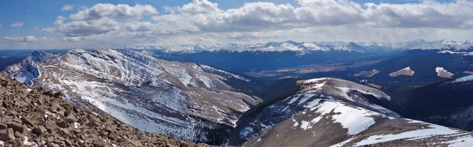
A spectacular panorama of the Red Deer River gap between Warden Rock (center) and Wapiti Mountain (right). Click to see larger.
.jpg)
Crux gets some love from Sonny on the long hike back to the trailhead.
.jpg)
Ya Ha Tinda Ranch panorama looking back towards Evangeline Peak (left), Rum Ridge Peak (center left), Eagle Mountain (center right) and Maze Peak (right). Click to see larger.
.jpg)
A closer look at Maze Peak.
.jpg)
Ya Ha Tinda in its full glory.
.jpg)
As we neared the end of our outing, I couldn't help but be struck by the beauty of this area. Ya Ha Tinda, with its dramatic contrast between peaks and prairies, is well-worth the long drive!
.jpg)
.jpg)
.jpg)
.jpg)
.jpg)
.jpg)