Anyone who knows me knows that I love my my Calgary Stampeders as much as I love my Rocky Mountains. Weekend trips to McMahon Stadium are just as important as weekend trips to the mountains! Occasionally, however, it becomes difficult to squeeze both in. On this particular weekend, for instance, I was unable to get out to the mountains on Sunday and a 5:00pm game on Saturday limited my options somewhat. Fortunately, an alpine start is a fine compliment to an early kickoff! Unwilling to settle for anything less than spectacular scenery, Crux and I were on the road to Lake Louise at 6:30am for an attempt on Devil’s Thumb: an objective which I hoped would prove both short and sweet!
.jpg)
A beautiful bluebird morning in Lake Louise! Thank God I dragged my butt out of bed! From the lakeshore, Devil’s thumb (center) isn’t much to look at; just a small (thumb-like?) projection above the Big Beehive (right) but below much loftier Mount Whyte (top center). Fortunately, what it lacks in prominence, it more than makes up for in location!
.jpg)
Crux enjoys the cool shade of the old growth forest en route to Lake Agnes and its famous tea house. With a deadline on my mind, I set a good pace that soon had Crux panting as we passed tourists on our way up the popular trail.
.jpg)
After 45 minutes of forested hiking, the view of the Big Beehive towering over Mirror Lake was a welcome excuse to stop for a photo (for me) and a refreshing drink (for Crux).
.jpg)
This is too easy for Crux! The peak bagging pooch powers up the stairs which ascend the final headwall below Lake Agnes. If only all mountains had easy staircases to the top, eh Crux?
.jpg)
Mount Whyte (left) and Niblock (right) provide a spectacular backdrop which makes Lake Agnes one of the most popular hiking destinations in the Rockies.
.jpg)
Devil’s Thumb (the highest pinnacle left of center here) rears skyways while we make our way along Lake Agnes’ clear blue waters towards the BOTL (back of the lake).
.jpg)
Thanks to crystal clear water, we could easily see trout milling about in Lake Agnes – unfortunately, this fellow (who appears to be a brook trout but may be a “splake”) is likely an unwelcome invader…
.jpg)
Colorful wildflowers along Lake Agnes’ green lakeshore.
.jpg)
Mount Whyte towers above emerald blue Lake Agnes.
.jpg)
A fresh dusting of summer snow on distant Ptarmigan Peak (right) adds to the scenery beyond the famous Lake Agnes tea house.
.jpg)
Crux pants his way up the steep switchbacks which lead from the BOTL up towards the Big Beehive.
.jpg)
At the top of the switchbacks, 4 trails intersect. To the left (east), an obvious trail continues up to the gazebo atop the Big Beehive. Straight ahead (south), a signed trail descends towards the Plain of Six Glaciers. Finally to the right (west), a well-travelled but unofficial trail (shown here) makes its way towards and up Devil’s Thumb.
.jpg)
The crux of the ascent on Devil’s Thumb (a rock band about 3 m high) is reached soon after leaving the official Big Beehive trail. The scrambling here is easy, however, the ledges leading up are awkwardly spaced for four-legged hiking partners. Crux needed a couple of “boosts” to get up here. For anyone else who might want to bring their canine climbing partner up Devil’s Thumb, bear in mind: it will be harder to get your dog down this section than it was to get him/her up!
.jpg)
Once above the crux rock band, the trail sidehills along south-facing ledges which grant spectacular views towards Mounts Lefroy and Victoria. In places, it looks like things will become “airy” with a steep drop below but the trail manages to chart a course which most hikers should feel comfortable on.
.jpg)
After enjoying the views from the ledge-top trail for 10 – 15 minutes, we reached a steep, grassy gully which leads to the Devil’s Thumb – Whyte col.
.jpg)
After climbing the steep gully, Crux and I were both gassed at the col; fortunately, the summit of Devil’s Thumb is only minutes away from here!
.jpg)
A steep drop to Lake Agnes is revealed as we hike up the final rock field from the col to the summit. Stay closer to the intermittent trail on the climber’s right if you’re looking to avoid airy spots.
.jpg)
About 2 hours after we left the Lake Louise parking lot, Crux and I enjoy a well-earned rest atop the scenic summit of Devil’s Thumb! For such a short objective, the views certainly didn’t disappoint!
.jpg)
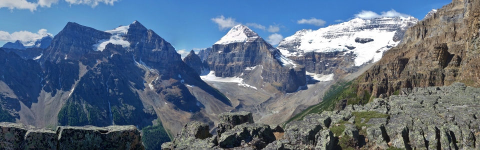
The panoramic views from the summit are like those from the popular Plain of Six Glaciers trail on steroids! From left to right: Protection Mountain (distant), Fairview Mountain, Sheol Mountain, Mount Temple, Haddo Peak, Mount Aberdeen, the Mitre, Wenkchemna Peak (distant), Mount Lefroy, Mount Victoria and Collier Peak. Click to see larger.
.jpg)
Rapidly receding glaciers leave a rubble field in their wake in the lush green valley below.
.jpg)
A closer look at oft-photographed Mount Victoria.
.jpg)
The boulder-covered Victoria Glacier winds up towards the Death Trap between Mounts Lefroy and Victoria. Once a popular route up to Abbott Pass Hut, the Death Trap exposes climbers to a high risk of serac collapse and avalanches from above and passes over many deep crevasses below. Today, nearly all parties get to Abbott Pass Hut via the much safer Lake O’Hara access on the other side.
.jpg)
The Mitre and Mount Lefroy. Nearby Abbott Pass and Hut are named for Philip Stanley Abbott, an American who became the first mountaineering fatality in North America during his attempt to make the first ascent of Mount Lefroy in 1896.
.jpg)
Mount Aberdeen and its classic north face glacier ascent route. Who would have guessed that there’s an easy scramble route hidden on the back side?
.jpg)
Massive Mount Temple just peeks out from behind Sheol Mountain.
.jpg)
Devil’s Thumb offers a spectacular panorama of glaciers to one side and colorful glacial lakes to the other! From left to right: Mount St. Piran, Lake Agnes, the distant Pipestone Valley, Little Beehive, Big Beehive, distant Skoki peaks, Lake Louise and Fairview Mountain. Click to see larger.
.jpg)
An aerial perspective of Lake Agnes and the (now tiny) tea house on its far shore.
.jpg)
Looking beyond Lake Agnes, up the Pipestone Valley towards remote and snowy Cataract Peak (center right).
.jpg)
Skoki peaks (from left to right: Mount Richardson, Pika Peak, Ptarmigan Peak, Fossil Mountain, Mount Douglas, Redoubt Mountain, Mount St. Bride and Lychnis Mountain) beyond Whitehorn Mountain and the Lake Louise ski resort.
.jpg)
Sandwiched between Agnes and Louise – lucky guy!
.jpg)
Devil’s Thumb may offer big views but it really is tiny compared to adjacent Mounts Whyte (left) and Niblock (right)!
.jpg)
Crux soaks in the scenery in his new harness/Iron Man suit. Eat your heart out Tony Stark!
.jpg)
Enjoying the last of the spectacular views from up high before hurriedly starting our descent – there was a Stamps game kicking off at 5:00pm after all! Click to see larger.
.jpg)
Following the scenic path back down from the Devil’s Thumb – Whyte col.
.jpg)
While there’s a path at the top of the descent gully, it quickly deteriorates as the entire hillside becomes uncomfortably steep dirt. Fortunately, this section is quite brief; just make sure that you keep an eye out for the good path along the correct ledge to the skier’s left, lest you end up descending this STEEP hillside all the way to the Plain of Six Glaciers trail in the valley bottom below!
.jpg)
Crux contemplates the down climb of the crux rock band. While this might be an easy scrambling step for humans, it’s pretty tricky for climbers of the canine variety! Although there are good ledge steps down, they were too narrow for a dog as big as Crux to safely jump down on his own. I essentially ended up “short roping” him from ledge to ledge to ensure that he could safely get down! Again, I wouldn’t recommend taking your dog up here unless you’re confident in your ability to get them safely back down this step!
.jpg)
Once back down at the Big Beehive trail junction, Crux and I opted to descend towards the Plain of Six Glaciers for variety. Unfortunately, the trail sign at the junction didn’t list distances so it wasn’t until a little later that we realized that we’d taken the longer way down!
.jpg)
Views of Lake Louise through the forest as we cut back to Mirror Lake along the Highline trail. While we had intended to descend all the way to the Plain of Six Glaciers trail, we eventually figured out that this would add a kilometer or so of unnecessary distance.
.jpg)
A quick dip (for both of us) to cool off in Mirror Lake before galloping back down the rock-hard Lake Agnes trail.
.jpg)
Finishing our day off with post card-worthy views of Lake Louise which by now (1:00pm) was a complete and total $hitshow! Fortunately, Crux knew that we were in a hurry to get back to Calgary for the Stamps game so he was not shy about bulling his way through the crowd of lakeside lollygaggers. With Crux blocking for me, we quickly left the hordes behind and were back on the road again! Thanks to our speedy 4.5 hour round trip time, I even had time to shower at home before donning the red and white and cheering the Stamps on to victory over the Bombers! A scenic summit and a stunning Stamps win (26 – 25!) – what a day!
.jpg)
.jpg)
.jpg)