Thanks to an unusually dry winter and the uncharacteristically early arrival of summer in southern Alberta, the bigger peaks in the main ranges of the Canadian Rockies are rounding into scrambling form at least a month earlier than usual! With a weekend of perfect weather forecast, I was eager to get out to my mountain playground to climb something spectacular. As the weekend approached, I got in touch with Marko Stavric to see if he was interested in teaming up for the first time since we met on the Wedge last June. As per usual, Marko was intrigued by the prospect of dramatic scenery. After discussing a couple potential objectives, I piqued Marko’s interest when I suggested Armor Peak.
After leaving Calgary early Saturday morning, I met Marko and his merry band of AAA peak baggers (Amelie, Alana and Andy) in Castle Mountain’s shadow at the Castle Junction gas station. Upon arrival, I was pleased to discover that Mike Mitchell (who I had previously climbed Mount Sarrail with) would also be joining us. From the gas station, we drove 12.6 km north along the Bow Valley Parkway (Highway 1a) and parked at a pullout on the south side of the road.
.jpg)
A creek running immediately north of the roadside pullout offers a glimpse of our snow/scree ascent slopes beyond the forested valley bottom. The actual summit of Armor Peak remains hidden to the left from here. On the north bank of this creek, we found and followed the old trail leading to the abandoned Protection Mountain mine. Although the trail was faint at first, it quickly became more substantial and proved quite easy to follow.
.jpg)
Mike crosses one of the “ghetto” bridges which traverses some marshy terrain in the valley.
.jpg)
Except for the occasional lady slipper orchid there’s little to see for the first several kilometers as the trail makes its way along through the forest.
.jpg)
Following a relatively flat 45 minute warm-up, the trail finally starts to climb more steeply. While conversation had been rampant on flatter terrain, only Amelie and Alana seemed to keep theirs going while the rest of the boys huffed and puffed up the hill.
.jpg)
After about 2 hours, we finally broke through the tree line and were treated to our first views of the Lake Louise group’s massive peaks across the Bow Valley.
.jpg)
A fine spot for a snack! Half the group enjoys the Bow Valley scenery while the other half discusses various possible routes up to the ridge crest. The Golden Scramblers, Vern, Wietse and Raf made use of a steep snow gully on the left to gain the high ridge while Bob Spirko employed more open scree slopes on the far right. In the end, (most of) our group opted for Spirko’s longer but more conservative line.
.jpg)
The decision to take a more conservative line up scree to the ridge was made based on the premise that kicking steps up steep snow in a south-facing gully on a hot, sunny day might not be brilliant. Our traverse to reach the snow-free rubble slope, however, still required us to gross several south-facing snow slopes. A conscious effort was made not to linger in spots like this!
.jpg)
Andy exploits some hard-packed avy debris to cross the, otherwise, soft snow with relative ease.
.jpg)
At some point, Mike got sick of traversing and just decided to climb the damned mountain (he’s faintly visible pursuing his more aggressive line to the center left of this photo). Mike reported that his route was “wet, down-sloping, very exposed and completely unnecessary.” Mouse over to see a photo he took looking down his route – yikes!
.jpg)
The rest of us opted for a simple scenic slog. As we groveled up the rubble, Marko was quick to inform the others that Armor Peak had been my idea not his – thanks Marko! ;-)
.jpg)
Slog, slog, slog! Marko pauses to rest and enjoy the view just below the ridge crest.
.jpg)
Looking towards TV Peak (the highest point of the Protection massif) from where we crested the ridge; an out-of-place stick seems to mark the easy rubble slopes below for those descending this way following the long traverse from the Castle Mountain massif.
.jpg)
Once we crested the ridge, we were finally able to see Armor Peak (the summit on the far right). Although the peak looks tantalizingly close, it was still over 3 km away at this point. To make matters even more interesting, the intervening 3 km would feature a LOT of snow.
.jpg)
Alana, Amelie, Andy and Marko do their best to avoid the waist-deep isothermal snow while enjoying the scenic walk along the ridge top.
.jpg)
On the steep scree slopes below, I had been reluctant to take credit for choosing Armor Peak as an objective. Up high with a wonderful view of Mount Temple across the Bow Valley, I was, however, much more inclined to do so!
.jpg)
As we pressed on towards Armor Peak, the snow capping the scenic ridge grew more and more difficult to avoid.
.jpg)
Typical type 2 fun in the isothermal snow. Whose idea was this anyways? (Photo courtesy Marko Stavric)
.jpg)
With spectacular views all around and a sea of snow still between us and the summit, most of our group decided that enough was enough and opted to end their day here. Mike and I, however, decided that we’d suffered too much at this point not to claim the actual summit so we pressed on. Click to see larger.
.jpg)
Approaching Armor Peak’s impressive ramparts. These are the steep west-facing walls which “protect” Wonder Valley to the east.
.jpg)
After wading through 3 km of waist-deep snow along the ridge, Mike contemplates the final steep slope to the summit. Having seen and heard much evidence of snowpack instability, we avoided any steep snow slopes which had been baking in the hot afternoon sun and, instead, chose a line which directly ascended the imposing but dry ridge crest.
.jpg)
Delightful hands-on scrambling on steep, horizontally-layered rock provided a great finish to a long day!
.jpg)
Mike finally claims the spectacularly scenic summit of Armor Peak 7 hours after setting off from the trailhead! Click to see larger.
.jpg)
Sharply-split Bullwark Peak rises dramatically at our feet. Bullwark is the northernmost high point of the Protection massif and guards Wonder Valley (right) from the Skoki Valley beyond.
.jpg)
Enjoying a well-earned respite on the summit! The combination of post-holing and relentless May sun proved quite draining on ascent!
.jpg)
A panorama of snowy peaks rise up along the continental divide. From left to right: Storm Mountain, Mount Ball, Beatrice Peak, Stanley Peak, Mount Haffner, Numa Mountain, Floe Peak, Boom Mountain, Foster Peak, Mount Whymper, Mammoth Peak, Mount Bell, Tumbling Peak, Chimney Peak, Mount Bident, Mount Quadra, Panorama Ridge, Mount Fay, Mount Babel, Mount Bowlen, Mount Allen, Mount Tuzo, Deltaform Mountain, Neptuak Mountain, Mount Temple, Ringrose Peak, Glacier Peak, Little Temple, Mount Lefroy, Mount Aberdeen, Mount Victoria, Haddo Peak, Sheol Mountain, Collier Peak, Saddle Mountain, Mount Fairview, Pope’s Peak, Mount Whyte, Mount Niblock, Mount St. Piran and Mount Carnarvon. Click to see larger.
.jpg)
A stunning view of the Lake Louise Group.
.jpg)
Mounts Lefroy and Victoria tower above Mount Aberdeen, Haddo Peak and Sheol Mountain.
.jpg)
Massive Mount Temple (as Steven Song would say: “the majesty!”).
.jpg)
The Valley of the Ten Peaks.
.jpg)
Chimney Peak (left), Mount Bident (center) and the characteristic quadruple summit of Mount Quadra (right).
.jpg)
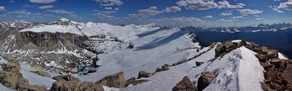
Looking down the 5.5 km length of the high ridge separating Armor Peak from TV peak. A spectacularly snowy high plateau divides Pulsatilla Mountain (left) from the Protection Mountain massif. Click to see larger.
.jpg)
Pulsatilla Mountain towers above rarely visited Mitella Lake, dominating the view to the east.
.jpg)
Helena Ridge and TV Peak beyond the snowy karst pavement plateau. We gained Protection’s ridge near the high point immediately right of TV peak and, soon, will have to post-hole all the way back!
.jpg)
The repeater on TV Peak (Protection Mountain’s true summit) is faintly visible. In the distance, clear skies grant us a view of “the Matterhorn of the Rockies” Mount Assiniboine.
.jpg)
Giant peaks across the Bow Valley in Kootenay National Park.
.jpg)
A closer look at Storm Mountain, Mount Ball and Stanley Peak.
.jpg)
Looking north beyond Bulwark Peak and the Skoki Valley towards the more distant Wapta Icefield. Click to see larger.
.jpg)
Massive Mounts Douglas (left) and St. Bride (right) beyond Lychnis Mountain.
.jpg)
Skoki landmarks Mount Richardson, Redoubt Mountain, Pika Peak and Ptarmigan Peak beyond beautiful Bulwark Peak. Mounts Willingdon and Harris are also faintly visible in the distance.
.jpg)
Mounts Hector and Richardson to the north. On the left, Howse Peak, White Pyramid and Mount Chephren are visible in the distance while Mount Andromache can be seen between Hector and Richardson.
.jpg)
Mount Daly (left), Mount Balfour (center) and Mounts Gordon and Olive (right) are obvious high points on the Wapta Icefield beyond snowy Lipalian Mountain.
.jpg)
Snapping one last scenic summit photo before starting the long trek down.
.jpg)
Mike begins to make his way back along the high ridge amidst a stunning panorama of peaks. Click to see larger.
.jpg)
Pausing to enjoy the view.
.jpg)
Our return trip along the ridge proved relatively quick thanks to the trail which we painstakingly broke earlier in the day. Many ups and downs along the ridge, however, proved draining as the day drew on. Although the net elevation gain for Armor Ridge is 1410 m, my GPS recorded the gross gain as being somewhere in the ballpark of 1750 vertical m.
.jpg)
Back to our scree ascent/descent slope. We would descend this slope until its base so that we wouldn’t have to traverse steep south-facing snow gullies to regain the Protection Mountain mine trail (right).
.jpg)
Mike readies himself for the knee-jarring rubble descent. Somewhere on this slope, I managed to lose my bear spray…still not sure how that happened!
.jpg)
More post-holing! When we reached the base of the rubble slope, we quickly wallowed our way across the snow gullies. The theory was that crossing lower down where the gullies were less steep would expose us to less avalanche hazard; even so, we powered across these slopes as quickly as we could!
.jpg)
A raging waterfall suddenly disappears under early season snow. Once across the waterfall, we found ourselves back near the Protection Mountain mine and were making our way back down the good trail towards the valley bottom a short time later.
.jpg)
Shadow overtakes the valley bottom as evening light illuminates the peaks above. 11.5 hours after we set out, we found ourselves nearing the trailhead as the sun started to set.
.jpg)
Of course the one time that I lose my bear spray, we find this friendly furry fellow waiting near our vehicles! Fortunately, he didn’t seem to be interested in making our acquaintance!
From spectacular views above to wildlife run-ins below, Armor Peak proved to be an excellent choice (except for all the post-holing – whose idea was that anyways?)! Outstanding type 2 fun for sure!
.jpg)
.jpg)
.jpg)
.jpg)
.jpg)
.jpg)