Yates Mountain (Barrier Lake Lookout) and McConnell Ridge
Elevation: 1996 m
Elevation Gain: 625 m
Yates Mountain is the unofficial name of the high point of McConnell Ridge immediately north of Barrier Lake. The peak was named after Emily Yates who ran the Diamond Cross ranch which was located on the site presently occupied by nearby Camp Chief Hector. The peak has a long history of serving as a lookout, beginning with the Stoney Nakoda whose name for it, Tokyapebi Ipa, can be translated to: “Lookout Point for the Enemy.” Today, the peak is the site of the Barrier Lake fire lookout.
My Ascents:
January 1 2014
Trailhead: Barrier Dam Day Use Area
GPS Track: Yates Mountain
After a failed winter solstice snowshoe attempt on Yates Mountain the week prior, I decided to ring in the New Year (and clear my head of some New Year’s eve cobwebs) by taking care of some unfinished business and bagging diminutive Yates Mountain once and for all. Although we had used snowshoes a week earlier, the lack of fresh snow in front range Kananaskis Country prompted me to leave the ‘shoes in the trunk and proceed up, what was by now, a very well-broken trail. I didn’t exactly get an alpine start (departing the car at 11:00 am), however, I figured that I had a pretty good chance of being the first person to summit Yates in 2014. Little did I know that a large group had actually rung in the New Year on the summit at midnight the night prior. Alas, they may have beat me up Yates this year but at least there was a phenomenal trail broken the whole way to the top!
.jpg)
Another sunny and clear day at Barrier Lake. Unlike a week earlier, the weather was mild and there was hardly even any wind (at least by Barrier Lake standards).
.jpg)
Mount Kidd’s impressive north face from Barrier Lake.
.jpg)
Crux makes his way towards the objective. Mount Yates is the high point of McConnell Ridge (right).
.jpg)
After enduring the dull 5 km walk through the woods for the second time in as many weeks, we emerged into the warmth of the sun light in the high clearing that had been our turn-around point last time. This time, summit or bust!
.jpg)
Just beyond the clearing, the terrain briefly steepens.
.jpg)
By-passing McConnell Ridge’s east-facing cliffs to make our way up to the giant repeater station at the scenic sub-summit.
.jpg)
Following the steepest part of the trail through the woods.
.jpg)
From the repeater-bearing sub-summit, the true summit is but a short, treed jaunt away. The sub-summit is, however, very scenic and merited a quick visit for some photography.
.jpg)
Mount Baldy casts a long shadow over Barrier Lake from the sub-summit.
.jpg)
The “Prairie View Trail” which leads to the sub-summit lives up to its name!
.jpg)
New Year’s puppy.
.jpg)
Front Range panorama from the sub-summit. Click to see larger.
.jpg)
As we left the sub-summit, the view to the north began to open up nicely.
.jpg)
Door Jamb Mountain and Loder Peak.
.jpg)
Yamnuska.
.jpg)
On top! Crux waits for me at the Barrier Lake Fire Lookout which is perched atop the summit of Yates Mountain.
.jpg)
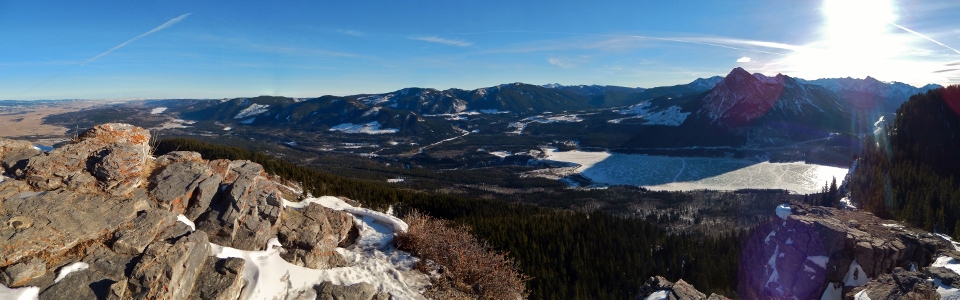
Summit panorama of the Bow Valley from the eastern edge of the Front Ranges. Click to see larger.
.jpg)
My first summit of 2014!
.jpg)
A closer panorama of the peaks surrounding Canmore and the Bow Valley to the west. Click to see larger.
.jpg)
The Three Sisters.
.jpg)
Mount Lawrence Grassi and Ha Ling beyond Lac Des Arcs.
.jpg)
Grotto Mountain.
.jpg)
Mount Fable.
.jpg)
The Kananaskis Valley to the south under some very cool looking clouds.
.jpg)
Mount Lougheed (left) and the Three Sisters (right) make an appearance behind Mount McGillivray.
.jpg)
Late afternoon light on massive Mount Kidd.
.jpg)
Thank God for the large group that broke trail the night prior. As you can see, the snow was unusually deep for this area of the Rockies!
.jpg)
Looking over the prairies from the lookout’s heli-pad.
.jpg)
Calgary on the horizon.
.jpg)
BIG STRETCH in preparation for descent.
.jpg)
On my way down, I decided to extend my day by making my way up McConnell Ridge (shown here).
.jpg)
Crux investigates some geological instability en route to McConnell Ridge.
.jpg)
Unfortunately, there was no broken trail on McConnell Ridge. Since the well-broken trail up to Yates Mountain had made life so easy for me, however, I decided that I needed to suffer a little and proceeded to post-hole my way through the woods up to the high point of McConnell Ridge.
.jpg)
The only tracks along McConnell (about the size of my hand). Feline?
.jpg)
Looking towards Mount Baldy from the high point of McConnell Ridge.
.jpg)
Midnight Peak beyond Mount Baldy’s 3 summits (foreground).
.jpg)
While I had originally wanted to traverse McConnell Ridge and descend it’s south end to Barrier Lake, the brutal knee – waist-deep snow convinced me to turn around at the high point and return via my ascent route even though this would involve my fourth trip along the dull forested ascent trail in a week. The clearing atop the treed hill in this photo is the point at which all views cease as you enter the woods. In the interest of shortening my suffering, I ran down to Barrier Lake from there.
.jpg)
Another Barrier Lake sunset ends a beautiful New Year’s Day in the Rockies.
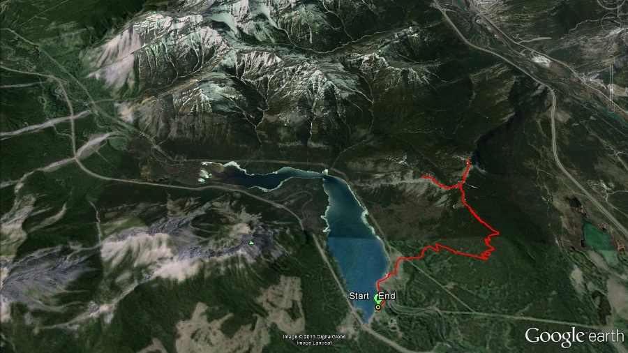
GPS track of the day’s outing thanks to a wonderful Christmas present from my wife!
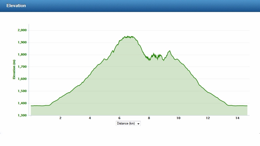
Elevation profile for the day.
.jpg)
.jpg)
.jpg)