After blowing out his Achilles tendon over the winter, it was great to hear that my buddy Mike was looking to get back out to the mountains for his first scramble of the year with Brianne, Crux and I. Mike even decided to bring a friend (Jemma) along for Crux. Not wanting to push his Achilles too much on his first day out, we decided that we should keep things under 1,000 vertical meters but hoped to do so without sacrificing scenery. Enter Wastach Mountain; Situated between the Valley of the Ten Peaks and Paradise Valley, this relatively small peak was certain to pack a scenic punch! Unfortunately, the scenery wasn’t the only punch that we had in store on this day as the truly unpleasant boulder field high up on this peak KO’ed the dogs’ chances of making it to the summit.
.jpg)
After making our way up the switchbacks leading from Moraine Lake towards Larch Valley, we followed the well-travelled trail which contours around Eiffel Peak to Eiffel Lake. As you can see, this flat trail offers wonderful views of the Valley of the Ten Peaks and Moraine Lake! Click to see larger.
.jpg)
While much of the trail was clear, several patches of compacted snow had to be crossed as we neared Eiffel Lake. Here you can see Mike preventing Jemma from going for an involuntary glissade (who knew that doggy hiking booties were so slippery?).
.jpg)
Crux was more interested in eating the snow than crossing it. Kinda blocking the path Buddy…
.jpg)
Brianne was happy to be back out in the mountains. Between her work and marathon training, it had been way too long since we had a chance to get out together!
.jpg)
Mike was happy to be back in the mountains too. Wastach Mountain can be seen behind him to the right.
.jpg)
Above Eiffel Lake, this gully between Wastach Mountain and Eiffel Peak grants access to Wastach Pass and Wastach Mountain above.
.jpg)
Taking advantage of early season snow to avoid a scree grind by kicking steps up the gully. Everyone’s still smiling at this point.
.jpg)
Above the gully, the upper boulder-strewn slopes of Wastach come into view. We aimed for the snow patches on the left hoping that easy travel on snow would allow us to dodge the majority of the nasty boulder field above. What we hadn’t banked on, was how steep some of these snow patches actually were and how rotten the boulders surrounding them would get.
.jpg)
Eiffel Peak (right) and the Eiffel Tower look awesome from Wastach’s ascent slopes.
.jpg)
Hmmm…these slopes are steeper than they looked from below.
.jpg)
Jemma modeling her new vibram-soled puppy booties: perfect for scree slogs (lest we have a repeat of the Mist Mountain incident)!
.jpg)
The scree gives way to loose and annoying large boulders higher up. Note that the smiles previously captured on camera now seem to be absent.
.jpg)
Enough of this! These large boulders were steep and loose. Even those which looked sturdy often shifted once you put your weight on them. This was not puppy-friendly (nor people-friendly) terrain. This is where Crux and Jemma’s day came to an end as Brianne graciously agreed to watch the dogs from the shelter of a large snow scoop nearby while the men stubbornly made their way up to the summit 100 m above.
.jpg)
Crux was very sad to be stuck in the snow scoop while Mike and I continued onwards. Sorry (to my wife and the dogs) for picking this mountain…
.jpg)
While Mike and I continued upwards, large avalanches roared noisily across the valley.
.jpg)
Sick of the boulders, we ascended hard snow despite the fact that it was much steeper (40 degrees) than we had expected. Definitely a good spot for an ice axe!
.jpg)
Higher up, we had to be careful to stay well to the climber’s left of a cornice before gaining the short ridge to the summit (pictured here). Click to see larger.
.jpg)
On top (but without my best friends Brianne and Crux).
.jpg)
Looking beyond the summit cornice down to Paradise Valley with a sunny Mount Temple stealing the show.
.jpg)
Looking down Paradise Valley towards the Lake Louise ski resort and Skoki (Cataract Peak, Mount Richardson, Pika Peak, Ptarmigan Peak and Fossil Mountain are all visible in the shade).
.jpg)
Massive Mount Temple’s southwest ridge rears up beyond Pinnacle Mountain.
.jpg)
An overcast Paradise Valley panorama. From left to right: Mount Lefroy (in the clouds), the Mitre, Mount Whyte (distant), Mount Aberdeen, Haddo Peak, Sheol Mountain, Skoki (distant), Mount Temple, Pinnacle Mountain and Eiffel Peak. Click to see larger.
.jpg)
Mount Aberdeen and Haddo Peak.
.jpg)
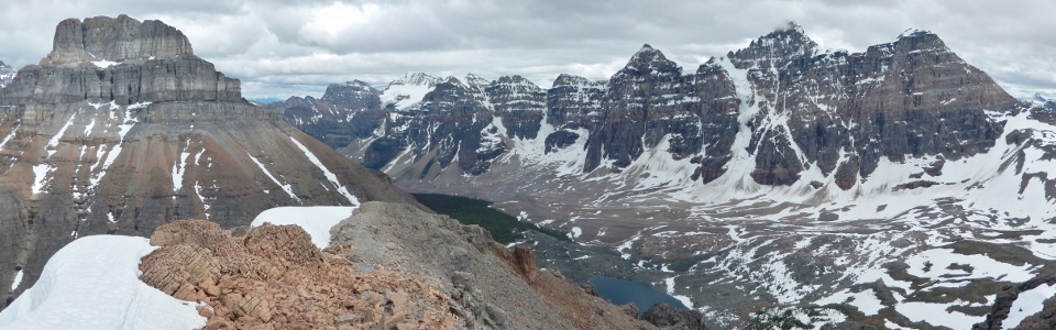
Despite less than ideal conditions, the Valley of the Ten Peaks always makes for a fine summit panorama! From left to right: Eiffel Peak, Mount Babel, Mount Fay, Mount Bowlen, Mount Little, Tonsa Peak, Mount Perren, Mount Tuzo (above Eiffel Lake), Deltaform Mountain and Neptuak Mountain. Click to see larger.
.jpg)
A worthy first summit of the season for Mike. Welcome back to the scrambling scene!
.jpg)
The Wenkchemna Glacier plunges down the steep north face of Deltaform Mountain to the valley below.
.jpg)
Looking west over the continental divide and Wenkchemna Pass; Curtis Peak visible in BC on the other side with the much larger Goodsir Towers obscured by cloud in the distance.
.jpg)
Wenkchemna Peak (left) and Glacier Peak (right) lie just below the clouds while the larger Mount Hungabee (center) pierces through them.
.jpg)
With overcast skies and Brianne waiting below with the dogs, Mike and I spent little time on top and began our descent after taking a quick summit self-timed photo.
.jpg)
Carefully descending steep snow to get back to Brianne and the dogs.
.jpg)
Once we got back to Brianne, we wasted some time searching for an easier, more puppy-friendly way down. Unfortunately, we didn’t find one so we ended up retracing our steps over loose and blocky terrain. As boulders eventually gave way to scree and scree eventually gave way to snow, all of our moods improved.
.jpg)
As much as the boulder field sucked, the glissade below it was outstanding! By this point, the dogs have clearly forgiven me for taking them through the boulder field above!
.jpg)
Lower down, some blue sky even decided to make a cameo appearance above Mount Tuzo, Deltaform Mountain and Eiffel Lake!
.jpg)
Back on the hiking trail and settled in for a long but scenic walk back to the car.
.jpg)
Beautiful Mount Fay.
.jpg)
While the hike back out isn’t excessively long, it began to feel that way. Fortunately, views of Tonsa Peak (left), Mount Perren (center) and Mount Allen (right) helped to pass the time. In short order, we were all back down and ready for our next scramble adventure (which I promise will not feature a large slope of unstable boulders)!
.jpg)
.jpg)
.jpg)
.jpg)