Tent Ridge
Elevation: 2545 m
Elevation Gain: 825 m
Tent Ridge was unofficially named as a result of its tent-like shape. Although the ridge had, for some time, been slated for development (a gondola, ski lifts, a lodge and restaurant) these plans, fortunately, never came to pass.
My Ascents:
October 13 2014, August 16 2013
Trailhead: Tent Ridge Trailhead
GPS Track: Tent Ridge
Thanksgiving is a day to be thankful for life’s many blessings and in the spirit of the holiday, I would like to take a moment to give thanks for:
• The Kula Tectonic Plate (gone but not forgotten): this oceanic plate began to subduct beneath the North American plate some 80 million years ago.
• The Laramide Orogeny: the subduction of the Kula plate produced the large structural deformation (or orogeny) of the North American crust which thrusted sedimentary rocks upwards, producing the Canadian Rockies.
• The Quaternary Ice Age: periods of extensive glaciation beginning 1.8 million years ago covered much of Canada with a thick layer of ice. This, it turns out, is the perfect recipe for the formation of jagged peaks and carved the mountains that I so love.
With so much to be thankful for, it’s easy to forget some of the smaller things. In relation to the geological processes mentioned above, my family is (literally) small but I definitely haven’t forgotten about them! In fact, of all of my blessings, I am most thankful for my family (and it’s not just because they climb mountains with me).
So, in the spirit of Thanksgiving, it seemed only appropriate to spend October 13 2014 in the Canadian Rockies with my parents.
.jpg)
After Brianne and I hiked up Tent Ridge following our engagement photo FAIL last summer, Gord asked if I would take him and my mom back up this scenic little ridge at the south end of Spray Lake someday. With the day off (and bellies full of turkey from the night prior), Thanksgiving Monday seemed like a good day to fulfill his request. Whereas my first ascent of Tent Ridge had taken place on a sunny August afternoon, this mid-October ascent was shaping up to be a fair bit colder. Noting that it was already cold and windy at the trailhead parking, we made the decision to forego the complete Tent Ridge “horseshoe” which involves a long ridge walk that visits 3 separate high points. Instead, we made use of the trail visible 100 m north of the parking area to more quickly access the north summit of Tent Ridge (this is the trail that those taking the “horseshoe” route will use on descent).
.jpg)
While the alternate Monica Brook trail up Tent Ridge (often used to ascend the “horseshoe”) is littered with deadfall, this is about as bad as the log-hopping gets on the Gawby Gulch trail that we took to directly access the ridge’s north end.
.jpg)
As the trees thinned, we were granted our first views of Tent Ridge’s north end rising steeply above. From here, the trail follows the drainage (Gawby Gulch?) directly above Gord’s head before side-hilling through open terrain towards the right-hand skyline ridge.
.jpg)
A large boulder in Gawby Gulch provided a convenient snacking spot from which to be thankful for leftover turkey sandwiches.
.jpg)
The views towards Spray Lake open up as we leave the shelter of the trees behind and forge upwards into the windswept alpine. Based on the preponderance of bare larch trees behind my mom, I’ve made a mental note to return here earlier in the autumn.
.jpg)
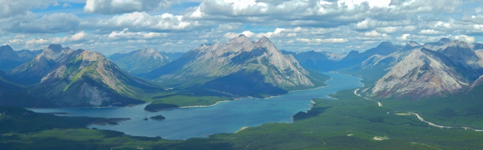
From the ridge crest, a beautiful Kananaskis panorama is revealed. From left to right: Mount Turner, Watridge Lake, Wonder Peak, Mount Cautley, Cave Mountain, Cone Mountain, Mount Turbulent, Mount Fortune, Spray Lake, Old Goat Mountain, Mount Nestor, Rimwall Summit, the Windtower, Mount Buller and Mount Engadine. Click to see larger.
.jpg)
The sun’s rays illuminate Cone Mountain.
.jpg)
Mount Turbulent’s rocky summit dwarfs grassy Mount Fortune (center left) across Spray Lake while Banff landmark Mount Rundle can be seen just behind an unnamed peak on the center right.
.jpg)
The Goat Range (left) and Mount Lougheed (right) sit in the clouds while smaller peaks (Rimwall Summit on the left and the Windtower on the right) at the far end of Spray Lake remain visible.
.jpg)
Summit photo with my two mountain hounds (sorry mom)!
.jpg)
The old folks for whom I’m thankful.
.jpg)
On a clear day, the panorama of the Kananaskis Range from Tent Ridge is outstanding, however, on this day, many of the area’s larger peaks were obscured by cloud. From left to right: Spray Lake, Rimwall Summit, the Windtower, Mount Buller, Red Peak, Mount Engadine, the Tower, Mount Galatea, Mount Chester and the north summit of Kent Ridge. On the right, you can see the other 2 high points of Tent Ridge which make up the “horseshoe.” Beyond Tent Ridge, the only peaks visible through the clouds on the right at Cegnfs Peak, Commonwealth Peak and the Fist. Click to see larger.
.jpg)
Looking down the length of Tent Ridge to its other 2 high points. Although the high point on the right is the true summit, it’s 1.5 km away from the north summit and only 30 meters higher. Given the frigid wind and heavier clouds at the south end of the ridge, we opted to forego the traverse!
.jpg)
Mount Buller (left), Red Peak (center) and Mount Engadine emerge (briefly) from the clouds.
.jpg)
Crux hunkers down to enjoy a break out of the wind while Gord freezes his hands trying to take summit photos. Clearly 1 of these 2 animals is smarter than the other! ;-)
.jpg)
Crux looked so comfortable that mom and I decided to join him. Unfortunately, the views towards Mounts Birdwood (left) and Smuts (center) did not improve during our brief summit stay.
.jpg)
One last photo of the “million dollar” view before heading back down in order to escape the bone-chilling wind!
.jpg)
Crux, mom and I make our way down while the photographer lingers (typical).
.jpg)
Crux wonders how we stay so warm without fur on freezing summits! Fortunately, our descent was rapid and in no time we were back to the shelter of the trees. From there, our short hike back to the car was filled with visions of the leftover turkey that awaited us at home!
.jpg)
.jpg)