Most athletes will tell you that they prefer playing over practicing. I suspect that the same is true with peak baggers. One of the reasons that scrambling has become so popular is that it affords those with limited technical skill, the opportunity to get out and summit a wide range of different peaks. When I started scrambling, I may not have known how to tie a figure eight knot or place an anchor but, blessed with perseverance and an unusually high tolerance for loose scree, I would frequently end up on the same summit as more skilled mountaineers. As a result, I rationalized not committing the time and money required to upgrade my own skill set; after all a 2 day course would cost a decent amount of money and “rob” me of 2 days which could be used to pad my summit tally.
There comes a time, however, in every career (be it athletic or peak-bagging) where you want to step your game up and, in order to do so, will have to take a step back and commit more time towards learning and practicing new skills. After 141 different summits of varying technical difficulties, I decided that it was time to invest in some formal mountaineering training and signed up for a 3 day introductory course with a highly reputable local guiding company, Yamnuska Mountain Adventures. The course itinerary called for 2 days of training at the spectacular Columbia Icefields followed by an ascent of Mount Athabasca (condition-dependent). Although I signed up on my own, I was pleased when Anne and James decided to join me since good company always makes for better days in the mountains!
Day 1
After a very early wake-up (why did I drink that strong beer the night before?), I left Calgary at 4:45 am in order to meet with the guides and other course participants at 9:00 am. Much of the morning was spent huddling under a tarp and trying to stay dry in the rain while the guides handed out gear and discussed its use.
.jpg)
By the afternoon, the rain had mostly let up and we made our way 5 minutes down the road towards Parker Ridge. As you can see, overcast conditions prevailed, with the summit of Mount Athabasca firmly entrenched in cloud.
.jpg)
We slowly made our way a couple of hundred meters up Parker Ridge in search of snow, passing by some spectacular wildflower displays en route. On the top left of this photo, you can just see the small snow patch that would eventually serve as our training ground. We ended up making ample use of this tiny snow patch learning important skills such as step kicking, proper self-arrest (who knew I’d been holding my ice axe backwards all these years) and building T-slot anchors. After a long day, we made our way back down and settled in for a night filled with practicing knots (while drinking beer) around the campfire at the nearby Beauty Creek hostel.
Day 2
.jpg)
Day 2 of the course dawned less rainy than day 1 but still very overcast. Fortunately, you don’t need clear skies to learn!
.jpg)
Finally time to gear up for a glacier! After spending day 1 in a campsite and on a snow patch, it was great to actually get out onto the Athabasca Glacier.
.jpg)
As you can see, not everyone who ventured out onto the glacier geared up. This family ducked under a large rope at the end of the designated trail and passed no fewer than 3 signs warning people to stay off the glacier before passing our group as we put on our crampons and harnesses. Unfortunately, you can’t fix stupid.
.jpg)
Practicing the most basic skill required for glacier travel: walking with crampons. The ice banks carved by small surface streams provided a good opportunity to practice on a variety of different slopes and angles. The key is to keep all 10 of the crampon’s downward-facing spikes on the ice regardless of whether or not this makes it look like Anne (wearing green in the center of the photo) will dislocate her ankles.
.jpg)
Bottomless pit? Hope that ill-prepared family didn’t decide to pose for a family photo down there…
.jpg)
Thanks to a HOT summer, the glacier was completely dry and snow-free revealing a number of interesting ice features including this ice bridge.
.jpg)
After learning to build anchors with ice screws, we were dropped, 1 by 1, into a reasonably benign crevasse in order to practice crevasse rescue.
.jpg)
“The view from Anne’s crevasse” (still sounds wrong Anne!) – Photo courtesy Anne.
.jpg)
By the late afternoon, the clouds had almost completely lifted and I was compelled to take some sight-seeing photos (looking towards the AA glacier here) during some of our down-time.
.jpg)
Thanks to the hot summer, Mount Andromeda’s popular “Skyladder” route has completely melted out.
.jpg)
One last panorama of myself on the Athabasca Glacier following another long day. Click to see larger.
Tomorrow: Mount Athabasca? Unfortunately not. Despite the fact that the weather was shaping up brilliantly for ascent day, the guides took a moment at the end of day 2 to inform us that they felt that the dry conditions meant that the rock fall danger on both of Athabasca’s less technical routes (the AA col and the north ramp) was simply too high. As a result, we would be ascending (and in my case, re-ascending) Boundary Peak tomorrow.
To say that I was disappointed would be putting things mildly. As the guides informed us of their decision, I felt completely gutted. The climb up Athabasca was to be the highlight of this course. Despite the fact that Boundary Peak is beautiful, it just doesn’t hold the same personal, aesthetic or technical appeal as the much larger Mount Athabasca. I spent the rest of the evening trying to be a good sport and trying not to pout but a couple of beers, dinner and good company did little to improve my mood. That night, I was almost completely unable to sleep as I kept looking up at the beautiful display of stars in the completely clear sky imagining the view from Athabasca’s summit.
Day 3
.jpg)
A beautiful dawn followed a restless and upsetting night. While I was thoroughly disappointed that we were climbing Boundary Peak, I was pleased that we would at least be ascending via the lower North Glacier granting us a chance to practice many of our newly acquired skills (when I climbed Boundary Peak 2 months earlier, I did so via the west-facing scramble route). I may have started the day grumpy but, ultimately, it’s impossible to stay that way in the mountains on a day as beautiful as this one.
.jpg)
Mount Athabasca at dawn. As before, the route up Boundary Peak would take us along the Brewster’s Snow Coach Road (foreground) to the cascading stream on the center right.
.jpg)
From the Snow Coach parking lot, we followed the stream upwards towards the toe of the glacier above on the left. For a description of the scramble route up Boundary Peak, please see my earlier trip report.
.jpg)
Working our way up the shaded boulder field while Mount Kitchener glows in the early morning light at our backs.
.jpg)
At the toe, we arrived to find the glacier plummeting steeply off of a headwall. From here, our ascent route would take us up the steep ice slope on the left. While Boundary may not be as lofty as Athabasca, this ascent would actually prove more technical as the steep ice forced us to build anchors and ascend 4 – 5 (60 m) pitches before the angle finally relented. Click to see larger.
.jpg)
A closer look at the beautiful waterfalls rushing off the North Glacier and down the freshly exposed headwall.
.jpg)
Up, up and away…
.jpg)
Starting to forget my disappointment and starting to enjoy, what would turn out to be, a beautiful climb.
.jpg)
My rope partner Chi builds our first anchor as the angle of the ice slope begins to increase.
.jpg)
After the first pitch, the angle REALLY increased! We gladly let our guide Mark set up this anchor. Taking this anchor back out moments later and front-pointing up the next 60 m proved to be more calf-burning than I ever could have imagined!
.jpg)
Above the steepest pitch, Mark found a nice flat(ish) platform that Chi and I could rest our calves on. This perch also afforded me the chance to capture the ever-improving panorama that was unfolding at our backs. Click to see larger.
.jpg)
Chi pauses to enjoy some more low-angled terrain (and stretch out his calves) while he can.
.jpg)
After pitching out the steepest section of the lower North Glacier in the morning shade, we arrived atop a relatively flat bench and felt the sun’s warmth for the first time of the day.
.jpg)
Sun rise over a buttress on the ridge connecting Boundary Peak (left) to Mount Athabasca (right).
.jpg)
The low-angled glacial bench provided a good spot for a break while we waited for subsequent rope teams (including Anne and James’) to catch up.
.jpg)
Mountaineering Matt.
.jpg)
Impressive seracs on the glacier above. Don’t worry – this is a telephoto; we were well outside the run-out zone of this icefall.
.jpg)
After a long break, we still saw no sign of the other groups, so we resumed our journey upwards, crossing the low angled glacier and aiming for the Boundary-Athabasca col. As we made our way off of the lower North Glacier, we were granted this view of Mount Athabasca’s Silverhorn summit (left) and the north ramp route (right).
.jpg)
A closer look at Athabasca's north ramp and the rock fall (dark streaks on the left) that thwarted our trip up it. Normally, I would have attempted to mitigate this risk by starting (and finishing) early, wearing a helmet and moving fast in this area. Alas, the guides know better than I and said that it was a “no-go.”
.jpg)
A different kind of rock fall hazard – off the glacier and set to scramble up the loose slope towards the Boundary-Athabasca col.
.jpg)
The lower north Glacier grows more distant as we ascend the final few switchbacks to the col.
.jpg)
At the col, Hilda Peak (center), A2 (right) and the Boundary Glacier are spectacularly revealed. I remember seeing this view when I crested for the first time 2 months ago and experiencing an “Oh WOW” moment. Two months later and this panorama is still worth a solid “WOW”! Click to see larger.
.jpg)
Where we were supposed to be.
:-(
.jpg)
After another 45 minute break, spent lounging in the sun at the col, we finally caught sight of Anne and James’ group – just cresting the steep section of the glacier hundreds of meters below! Suffice to say that we did not end up waiting for them as originally planned!
.jpg)
From the col, the scramble north along the ridge towards Boundary Peak was easy as we by-passed a large intervening buttress on the climber’s right.
.jpg)
The rest of our group makes their way up the final few meters to the summit of Boundary Peak with a background-full of Mount Athabasca.
.jpg)
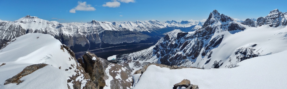
The group chats on the summit while I document the spectacular (albeit less snow-filled than last time) summit panorama dominated by an outlier of Nigel Peak (left), the Boundary Glacier, A2 (center), Mount Athabasca and the North Glacier (right). Click to see larger.
.jpg)
Nigel Peak to the north.
.jpg)
Cirrus Mountain (the glaciated peak in the center) to the east.
.jpg)
Mount Coleman.
.jpg)
Looking beyond a pinnacle towards the Boundary Glacier and the Hilda-A2 col.
.jpg)
Looking through the Hilda-A2 col towards Mount Amery (left), Cleopatra’s Needle (left) and Mount Saskatchewan (right).
.jpg)
A tarn where the toe of the Boundary Glacier used to reach.
.jpg)
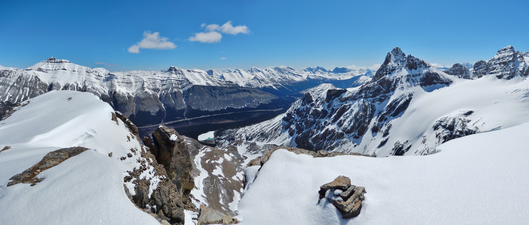
The panorama towards the Jasper National Park side of Boundary Peak was equally spectacular. Click to see larger.
.jpg)
Looking northwest along the Icefields Parkways towards Jasper.
.jpg)
Popular Kane scrambles – Mount Wilcox (left), Tangle Ridge (center) and Sunwapta Peak (right).
.jpg)
Looking towards the Sir Winston Churchill Range – from left to right: Mount Wooley, Mount Diadem and Mushroom Peak.
.jpg)
Mount Kitchener.
.jpg)
Snow Dome – the hydrological apex of North America.
.jpg)
Looking beyond Snow Dome towards the king of the Columbia Icefield: Mount Columbia – the second highest peak in the Canadian Rockies.
.jpg)
Looking down at our route up the lower North Glacier (below the waterfall in the bottom right of the photo).
.jpg)
Summit photo documenting my 2nd ascent of Boundary Peak this year. I’ll be back for you later Athabasca…
.jpg)
After an enjoyable stay on the sunny summit, we made a quick descent down Boundary Peak’s west-facing scree slopes. It turns out that these slopes are much looser (and more pleasant to descend) when they’re not frozen stiff! Following our speedy descent, we enjoyed a pleasant hike over rolling alpine terrain towards our vehicles below.
It may not have been the ascent that I was hoping for but Boundary Peak (part deux) was just as spectacular as before and granted me an excellent opportunity to practice many of the skills that I’d learned over the course of the weekend. It might not have been like playing in the “big game” but it was a damned fine practice! ;-)
Thanks to all of those who participated in the course and helped me to learn a valuable new set of skills: my rope partner Chi, Anne, James, (the other) Matthew, Jason, Colin, Jake, Jose, Patty, Milan and Warren. An extra special thanks to our wonderful guides from Yamnuska Mountain Adventures: Richard, Fred, Mark and Matt. I can’t wait for my next chance to be roped up (on a glacier, that is).
.jpg)
.jpg)
.jpg)
.jpg)
.jpg)
.jpg)