I’m told that the view from the summit of Red Peak is absolutely beautiful. Unfortunately, I can neither corroborate nor dispel that statement! Following a cold, rainy work week, the weekend weather looked as bleak as that which had preceded it. A person would have to be crazy to want to spend a day outside bagging a peak under such conditions.
Well, call me “crazy.” There was never really any question as to whether or not I would attempt to climb something on this particularly dreary Saturday; the real question was: could I convince anyone else to join Crux and I?
Enter the “Crazy Pol” Raf. Four months after enjoying our first peak together, Raf and I decided to team up once more. After debating a couple of different objectives, we eventually settled on the smallest of them given the poor forecast and thick fog. Of course, “small” is a relative term and, by the time all was said and done, my GPS indicated that Red Peak was a 23 km, 1400 vertical meter day. The reward for our efforts? A near complete summit white-out! Fortunately, the company was better than the view!
.jpg)
After a fog-filled drive to the Mount Buller trailhead, Raf and I made good time up the well-defined Buller Pass trail which can be found just across the highway from the parking area. The popular trail spends several kilometers in forest (including several burnt-out areas like this) before eventually leaving the trees behind. Alone, approaches like these tend to be tedious but Raf and I enjoyed good conversation throughout helping to pass the time.
.jpg)
After 6 km, we finally left the forest behind, arriving at the base of the steep 160 m ascent to Buller Pass (right).
.jpg)
Raf powers up the steep hiking trail to Buller Pass.
.jpg)
From the top of Buller Pass, we were granted our first views of the beautiful alpine valley to the east. The view left us with the distinct impression that there were mountains on this side of the pass but, with the low-lying clouds, it was really impossible to tell for sure. Indeed, the clouds wreaked havoc with our collective sense of direction, making it very difficult to orient ourselves. In the end, thanks to Raf’s topo map and my GPS, we were able to navigate our way towards the intended peak by descending the main trail to the boulder field visible in the lower left. From there, we crossed boulders briefly before making our way up to a small meadowy col to the north.
.jpg)
Crux works his way up to the meadowy col; Red Peak lies ahead on the right – completely obscured by cloud.
.jpg)
Crux and Raf take in the “view” from the meadowy col. As before, Red Peak (center right) is completely obscured by the cloud. From here, we descended towards the drainage in the center of the photo before ascending the ramp-like grass meadow towards the remnants of a large cornice in the upper center of the photo. Click to see larger.
.jpg)
Raf uses the remnant cornice to get the most out of his Red Peak workout. Who needs a Stair Master?
.jpg)
Meanwhile, Crux finds a more suitable use for the cornice.
.jpg)
Looking back down our ascent valley. Yep – still cloudy. From here, Red Peak is out of frame on the left of the photo. The obvious peak on the right is actually much lower than Red Peak (despite appearances from below). Click to see a larger, equally cloudy view.
.jpg)
At least the views of Ribbon Lake weren’t obscured by cloud!
.jpg)
Raf wonders why he got out of bed this morning as he makes his way up gentle scree towards the summit.
.jpg)
Just before the summit, we ran into another group of crazies on their way down. The small bump that they’re scrambling over is the only bit of hands-on scrambling that you’ll encounter on Red Peak and, even so, it can be COMPLETELY avoided to the climber’s right (left in this photo since it was taken looking back down).
.jpg)
Finally up – what a view!!! I’ve always wondered what the inside of a ping-pong ball looked like…
.jpg)
Raf quickly grabs his camera to get a shot of the view through the clearing to his right. In conditions like this, you either have to laugh or cry. Fortunately, Raf picked the former here.
.jpg)
The pretty alpine basin to the southwest. On this day, all of the views were below (as opposed to above) us.
.jpg)
A brief clearing grants a view of Spray Lake and the base of Mount Buller. Our summit stay was mostly spent sipping tea with occasional bursts of photography whenever the clouds cleared enough to see ANYTHING
.jpg)
Reassuring Crux that he is, in fact, a “good boy" prior to beginning our long walk back to the car.
.jpg)
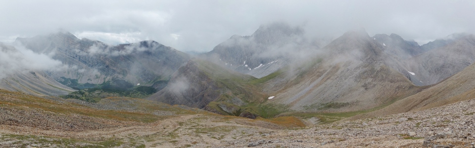
Back at the cornice, the panorama improved somewhat (or so I tell myself). Click to see larger?
.jpg)
My dad would tell me that clouds make for dramatic photography but I’d just as soon have clear blue sky thank you very much.
.jpg)
What goes up, must come down and then go back up before going back down. Looking forward to heading back up Buller Pass on descent.
.jpg)
Raf powers up Buller Pass (again)…this time from the other side.
.jpg)
At Buller Pass, a strange thing happened. The clouds ACTUALLY began to lift. For the first time all day, we were able to identify peaks and gain our bearings. Click to see larger.
.jpg)
Mount Bogart’s beautiful summit pyramid through the mist.
.jpg)
Mount Kidd’s dual north (left) and south (right) summits shed vapor as the clouds lift.
.jpg)
While Raf and I snapped photos at the pass, Crux (once again) found a better way to spend his time.
.jpg)
Looking back down our approach valley from Buller Pass. On a clear day, the view from here would be spectacular; the glaciers on the right-hand horizon are actually those at the base of Mount Assiniboine while Mount Engadine’s sheer north face would highlight the view to the left. Today, however, all that we could really see from here was how far (7 km) we still had to hike to get back to the car!
.jpg)
Crux enjoys a cool drink at the base of Buller Pass. Raf and I would enjoy some cool drinks as well, although we would have to wait longer (until Canmore) for ours.
.jpg)
The final views from the burnt forest on descent. In typical Rockies fashion, the clouds COMPLETELY cleared by the time that we reached our vehicle. As we drove towards Canmore, we were surrounded by blue sky and felt the warmth of the sun’s rays for the first time (just before it set behind the larger peaks to the west). I suppose all’s well that ends well…
.jpg)
.jpg)
.jpg)
.jpg)