With “spring” shoulder season now in full swing, another ascent of a small, grassy peak on the eastern front ranges of the Rockies was in order. I had originally planned to venture 3 hours south to the Crowsnest Pass like the week before but, at the last minute, decided to take a swing at a more local peak: Forgetmenot Ridge (with a possible extension to Old Forgetmenot and Forgetmenot Mountain). The reward for my change of heart: significant gas savings and the luxury of “sleeping in” until 7:00am on a Sunday!
.jpg)
The east face of Forgetmenot Ridge as seen from Highway 66 on approach. Although many parties hike to the top of the peak shown in the center of this photo, the actual high point of Forgetmenot Ridge is the broad plateau on the far left (which is about 10 m higher than the more northerly peak).
.jpg)
Beautiful morning views while crossing the Little Elbow River. From the trailhead, you actually have to walk away from Forgetmenot Ridge (and towards the Little Elbow campground) for several minutes in order to reach the suspension bridge from which this photo was taken.
.jpg)
After crossing the bridge, the northern end of Forgetmenot Ridge is obvious to the east. The trail up the ridge roughly follows the left-hand skyline ridge. Although there are trails in the trees, I opted to stay out in the open and hiked along the flood plain towards the objective.
.jpg)
Threepoint Mountain beyond a surging Elbow River. Due to a small lack of route research on my part, I had failed to realize (until this photo was taken) that a ford of the Elbow River would be required to reach Forgetmenot. Fortunately, there are large cairns marking a reasonable spot to ford the river (near the confluence of the Elbow and Little Elbow Rivers). Even here, however, the river was waist-deep in places as a result of the spring melt.
.jpg)
Crux makes his way through the bone-chilling, fast-moving water. Who doesn’t love fording glacier-fed rivers first thing in the morning?
.jpg)
After fording the Elbow, Crux and I followed the “Wildhorse Trail” the rest of the way to the Forgetmenot Ridge trailhead. Between walking away from Forgetmenot towards the bridge to start the day and exploring in an attempt to find a good spot to cross the river, almost 90 minutes passed before any elevation was gained!
.jpg)
Trailside treats for Crux!
.jpg)
After following the Wildhorse Trail for about 10 minutes, we reached the well-marked turn-off for Forgetmenot Ridge (flagged, cairned and marked by some serious erosion following last June’s floods).
.jpg)
The steep trail gains elevation quickly, providing good views (like this one of Powderface Ridge) in no time.
.jpg)
The Elbow River flows east towards Calgary.
.jpg)
The well-documented holey rock tree – a natural wind chime!
.jpg)
Crux scouts out the northern end of Forgetmenot Ridge. Based on the size of the cairn on the northern high point beyond, most parties appear to stop there despite the fact that the southern end of the ridge is actually higher.
.jpg)
Rocky Mountain Saxifrage provides the first evidence of spring above the tree line.
.jpg)
Views to the south begin to open up as the trail side-hills along scree towards the broad ridge crest.
.jpg)
Stormy weather over the prairies.
.jpg)
Calgary through the haze beyond the foothills.
.jpg)
After gaining the broad, grassy ridge crest, we followed it south towards Old Forgetmenot (pictured here). The bluff on the other side of the small col between Forgetmenot Ridge and Old Forgetmenot is most easily overcome to the climber’s left.
.jpg)
Crux works his way up the rocky bluff.
.jpg)
A snowy Banded Peak beyond a pair of rock pillars.
.jpg)
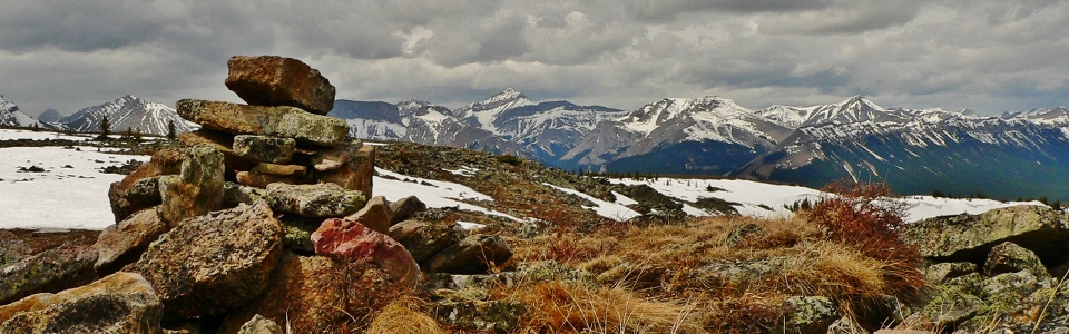
Twin cairns mark the summit of Old Forgetmenot (and the highest point of Forgetmenot Ridge/Mountain).
.jpg)
The summit panorama reveals the course of the Elbow River as it winds its way down from its source. Click to see larger.
.jpg)
Elbow River panorama. From left to right: Bluerock Mountain, Mount Rose, Threepoint Mountain, Mount Burns (background), Cougar Mountain, Mount Rae (distant) and Banded Peak. Click to see larger.
.jpg)
The snowy front ranges provide a scenic backdrop to a colorful pond.
.jpg)
Crux, as always, enjoying the view.
.jpg)
Beautiful Bluerock Mountain.
.jpg)
Mount Rae: the highest peak in the immediate vicinity and the source of the Elbow River.
.jpg)
From Old Forgetmenot, the ridge continues south towards Forgetmenot Mountain (which is actually a few meters lower). Although it was tempting to continue south, the weather was less than ideal and I didn’t want to risk my wife’s wrath by being late for dinner!
.jpg)
The requisite self-timed summit photo.
.jpg)
Banded Peak, Outlaw Peak, Mount Cornwall and Mount Glasgow (left to right) highlight the view immediately to the west. Click to see larger.
.jpg)
A closer look at Banded Peak (center) and Outlaw Peak (right).
.jpg)
Pyramidal Mount Glasgow.
.jpg)
More peaks to the northwest.
.jpg)
Flat-topped Mounts Romulus (left) and Remus (center foreground) highlight the view to the northwest along with pointy Mount Fisher (right).
.jpg)
Mount Fullerton and Mount Howard beyond Nihahi Ridge.
.jpg)
Crux the dog summits yet again!
.jpg)
Front range panorama to the north showing the broad grassy top of Forgetmenot Ridge. The point in the center is the more northerly summit where most parties stop for the day while the point on the right (southeast summit)is actually about 10 m higher. Click to see larger.
.jpg)
Moose Mountain beyond Forgetmenot Ridge to the north.
.jpg)
Keen to bag 2 peaks, Crux decided to investigate the southeast summit of Forgetmenot Ridge on our way back down from Old Forgetmenot. The ridge is so flat at this point that it’s actually hard to tell where the “summit” is!
.jpg)
Summit selfie on Forgetmenot Ridge. Counting this side-trip on the way down as a second peak might be a little chintzy but, after a round-trip distance of 18.5 km, I decided that I “earned” it.
.jpg)
Looking south towards Forgetmenot Mountain (left) and Old Forgetmenot (right) from the high point of Forgetmenot Ridge. Real peaks (including Bluerock Mountain) can be seen beyond.
.jpg)
Crux found a walking stick for the descent in order to save some wear and tear on his well-travelled 2 year old knees!
.jpg)
Enjoying some final views of the confluence of the Elbow (left) and Little Elbow (center) Rivers before returning to the treeline.
.jpg)
A busy day at Forgetmenot Pond below.
.jpg)
Rather than fording the Elbow River and then walking 10 minutes back to the suspension bridge before having to walk 10 minutes back to the trailhead parking, I opted to ford the Little Elbow River immediately after fording the Elbow, saving myself 20 minutes. For those wondering, no, I did not wet my pants; this photo was taken to document the depth of the river! In a further demonstration of laziness, I opted to keep my boots on for both of these fords since it was the end of the day and I had sandals in the car. As of my writing this (96 hours later), my boots are still SOAKING WET.
.jpg)
.jpg)
.jpg)
.jpg)