After a successful outing on Opal Ridge with Anne, James and Aurore last month, we were all eager to get back out for another day in the mountains. While catching up with old friends over beers is great, catching up with old friends on a mountain is vastly preferable! After debating the merits of a few different peaks via e-mail, we eventually settled on Noseeum Mountain as our objective. This decision was based largely on the wonderful photos that Marko Stavric posted from his trip there in 2013 and his accompanying trip report which highlighted an easy route through the headwall above Noseeum Creek. After enjoying a hearty breakfast of potato chips (guess whose idea that was), Brianne, Aurore, Crux and I met Anne and James at the unsigned Noseeum Creek pullout on the east side of Highway 93N, 1.0 km to the south of Mosquito Creek.
.jpg)
An outlier of Noseeum Mountain rises majestically behind Noseeum Creek. We quickly found a faint trail on the right-hand (south) bank of the creek and followed it upstream towards the headwalls.
.jpg)
After about an hour of relatively easy travel next to noisy Noseeum Creek, we arrived at the headwalls. The lower headwall (pictured here) features 2 large waterfalls cascading down its steep face. From here, we would follow Marko’s route, which begins near the waterfall on the right and follows a good trail up wide ledges between the 2 waterfalls. Although this is very close to where Vern Dewit ascended, we managed to stay off the moderate/difficult terrain that he describes.
.jpg)
Aurore earns some style points as she crosses Noseeum Creek just below the right-hand waterfall while Anne, James and Crux look on, marking sure that she doesn’t split her pants.
.jpg)
At the base of the first headwall, we found this 10 – 15 foot high steep gully which granted easy access to a trail immediately above.
.jpg)
Brianne and Crux follow the obvious trail up a series of ledges quickly leaving Noseeum Creek below. This trail eventually petered out on a forested plateau above the first headwall.
.jpg)
From the top of the first headwall, we made our way up and gradually to the climber’s left, eventually arriving at this beautiful waterfall coming down the base of the second headwall. There is an easy way up grassy slopes to the climber’s left of this waterfall but the blocky rock made it tempting to scramble directly up it (as you can see, I didn’t get far)!
.jpg)
Amazing views of the Molar Glacier and Mount Andromache as we break through the second headwall.
.jpg)
Above the headwalls, we emerged into a high alpine basin. This pristine basin is a beautiful spot which, despite being only a few km from the highway, has a genuinely remote feel to it.
.jpg)
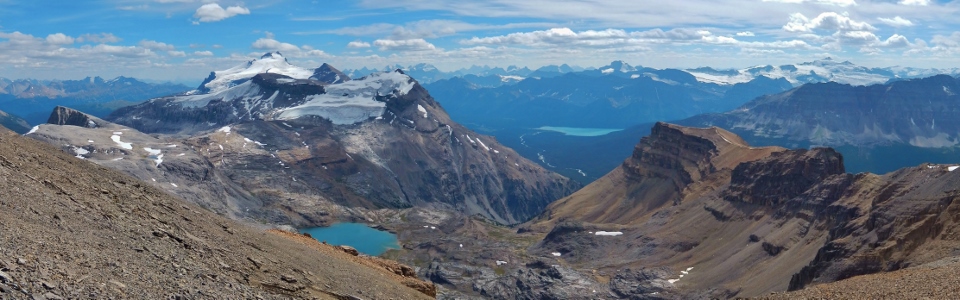
Noseeum Lake is the jewel of this alpine basin and provided a very scenic lunch-time panorama for us! Click to see larger.
.jpg)
From the alpine basin, Noseeum Mountain appears to be a long, curving ridge comprised of a series of five obvious high points. The high point on the far left is the cliffy outlier visible from the highway below while that on the far right is actually a gray-colored outlier of Mount Andromache (according to Google maps anyways). We ascended an obvious scree ramp just to the right of the second high point from the left, marking our way past the third high point from the left (false summit) to the fourth high point from the left (summit). Click to see larger.
.jpg)
A closer look at the scree ramp which grants relatively easy access to Noseeum’s ridge top. After staring at the scree for a while after lunch, we decided that it probably wouldn’t climb itself and started the slog up!
.jpg)
James makes his way up the scree ramp with Noseeum Lake now far below. This ramp is deceptively steep in places and very loose – definitely a good place to stay close together and wear helmets!
.jpg)
After groveling up the scree ramp, we arrived at a col which drops down to Mosquito Creek on the other side. The panorama of Bow Lake and the peaks to the north from the col instantly made all of the suffering on the scree below worth it! Click to see larger.
.jpg)
A closer look at distinctively shaped Dolomite Peak from the col. Cirque Peak can also be seen on the right while mighty Mount Forbes (eighth highest in the Canadian Rockies) rises up in the distance between the two.
.jpg)
Not sure who’s looking better: Aurore and Brianne or Mounts Hector (center) and Andromache (right)?
.jpg)
Crux contemplates the remainder of the route along the ridge to the summit. Unfortunately, I didn’t take many photos of the route here but, suffice to say, it is reasonably obvious. From the col, you can scramble directly up the ridge or along easier terrain just below the ridge crest to the climber’s left. After a few minutes, the ridge crest broadens and the scrambling becomes trivial. For some good photos of the route along the ridge top, check out the Golden Scrambler’s trip report.
.jpg)
After a brief jog (8 minutes) from the false summit (time was beginning to become a slight concern), we reached the true summit and were rewarded with this spectacular panorama of Molar Pass and a sea of peaks to the east. Click to see larger.
.jpg)
A closer look at the glacier falling from Noseeum Mountain’s north face to Molar Pass below. Cataract peak is the prominent glaciated peak on the left while Molar Mountain’s distinctive form is apparent on the right.
.jpg)
Looking beyond Molar Mountain towards a sea of familiar peaks in Skoki, including (from left to right): Cyclone Mountain, Pipestone Mountain, Mount Douglas, glaciated Mount St. Bride, Oyster Peak, Skoki Mountain, Lychnis Mountain (distant), Bonnet Peak (distant), Fossil Mountain and glaciated Ptarmigan and Pika Peaks.
.jpg)
A closer look at Cataract Peak.
.jpg)
Looking north towards Quartzite Peak (center left), Ramp Peak (center and gray) and Mosquito Mountain (right and orange). 11,000er Mount Willingdon is the prominent peak beyond.
.jpg)
A closer look at the 3 peaks of the Willingdon Massif (from left to right: Mount Willingdon, Crown and Tower) beyond Ramp Peak (left) Devon Mountain (center) and Mosquito Mountain (right).
.jpg)
Watermelon Peak (right) and its many outliers to the north. In the distance, the summit of Mount Weed (left) is obvious while the many towers of Mount Murchison can be seen on the center left (beyond the prominent southern outlier of Watermelon Peak).
.jpg)
Crux the dog enjoys a cool seat while taking in the spectacular summit view.
.jpg)
Matt enjoyed the summit view too!
.jpg)
One big happy family on top of Noseeum Mountain.
.jpg)
The panorama to the south features Mount Hector (center left), Little Hector (center left), Mount Andromache and Noseeum Mountain’s long ridge extending towards Hector Lake. Beyond, the horizon is dotted by massive peaks along the continental divide. Click to see larger.
.jpg)
Looking back along the glacier-carved south ridge of Noseeum Mountain. The col that we gained via the scree ramp is directly below the dark cliffs in the center. As you can see, from there, the scrambling gets progressively easier towards the summit.
.jpg)
The heavily glaciated east face of Mount Balfour beyond the less lofty summit of Bow Peak.
.jpg)
Giants of the divide beyond Hector Lake. From left to right: Waputik Peak, Park Mountain, Sentry Peak, Mount Bosworth, Mount Goodsir, Goodsir North Tower, Odaray Mountain, Cathedral Mountain, Cathedral Crags, Mount Stephen, Mount Daly, Mount Niles and Pulpit Peak (foreground).
.jpg)
The Louise Group (from left to right: Deltaform Mountain, Neptuak Mountain, Mount Lefroy, Mount Hungabee, Mount Victoria and Narao Peak) beyond the summit of Mount Andromache.
.jpg)
Mount Hector and the expansive Hector Glacier.
.jpg)
The Matterhorn of the Rockies, Mount Assiniboine was even visible in the distant haze beyond Mount Hector.
.jpg)
The full divide panorama from Hector Lake (left) to Bow Lake (right). Click to see larger.
.jpg)
Group summit shot.
.jpg)
Time to GTFD! Brianne and Aurore negotiate the blocky terrain along the ridge as we retrace our steps towards the col (where the ridge meets the dark cliff bands above Brianne’s head).
.jpg)
Looking back down the scree ramp from the col – suffice to say, the descent of this feature was much more pleasant than the ascent!
.jpg)
Pleasant meandering through the alpine basin (Anne and James – where are you?).
.jpg)
Final views of Mount Andromache and the Molar Glacier.
.jpg)
Noseeum Creek sparkles in the evening sun below the headwalls.
.jpg)
By retracing the GPS track from our ascent, our descent of the headwalls (including this – the last of the butt-scooching) was quick and painless.
.jpg)
Looking back up towards the southern outlier of Noseeum Mountain from the base of headwalls.
.jpg)
The girls make their way back across Noseeum Creek near the highway. Water levels in the creek definitely rose throughout the course of the day but fortunately, by this point, no one gave a damn about getting their boots wet!
.jpg)
The perfect way to end any scramble: creek-cooled victory beers in the sun (proving that you can catch up with old friends on a mountain AND over beers at the same time)!
.jpg)
.jpg)
.jpg)
.jpg)
.jpg)
.jpg)