Mount Swansea
Elevation: 1733 m
Elevation Gain: 800 m
Mount Swansea is part of the Stanford Range which lies directly east of the Rocky Mountain Trench above the town of Invermere, BC. The mountain is the site of a former copper mine and fire lookout and currently serves as a hub for local mountain bikers and paragliders. Copper ore extracted from the former mine was ultimately sent to Swansea, Wales for concentration. For this reason, Sam Brewer (one of the mine’s owners) named the peak Mount Swansea in 1891. In 1924, the BC Forestry Service established a fire lookout atop Mount Swansea where it remained until 1992.
My Ascents:
March 23 2014
Trailhead: Swansea Mountain Road
GPS Track: Mount Swansea
As part of a romantic BC winter weekend getaway that already saw Brianne and I spending a day cross-country skiing in Fernie and another downhill skiing in Kimberley, we planned to spend a final day hiking/snowshoeing in the area. Following an amazing meal at the Pedal and Tap in Kimberley (do yourself a favor and try the “mucky fries”), we decided to make our way up Mount Swansea near Invermere in the hopes of burning off some excess (possibly “mucky fry”-related) calories.
.jpg)
Despite failing to consult any local guidebooks, we easily found the trailhead by following Windermere Loop Road (just south of the Valley Alley Bowling Center on Highway 93/95) east until Swansea Mountain Road. Moments after turning onto Swansea Mountain Road, we came across a parking area and signed trailhead. Although you can drive up the road until just below the summit (what fun would that be?), my Honda Accord was no match for the winter conditions so we were “forced” to hike up. There are a myriad of trails on the mountain and, while hiking and biking trails are clearly distinguished, signage indicating where the various trails go is significantly lacking. By following (or at least attempting to follow) the “Swansea Slopes” trail, we were, however, able to make our way to the summit.
.jpg)
Trudge, trudge, trudge…Brianne making her way up the steep, dry lower slopes of Mount Swansea. Based upon the dry conditions present in the valley, we opted to save weight and left our snowshoes in the car. As we gained elevation and encountered increasingly deeper snow, however, we began to question the wisdom of this decision.
.jpg)
One of the many “helpful” signs en route. While the sign made it clear that we could essentially hike in any direction that we pleased, it would have been nice to know where each of these trails led. By following the most obvious trail, we actually ended up ascending a small outlier west of the much larger summit bump.
.jpg)
Googling directions atop the outlier. We ended up following the green “hiker” sign just above Brianne’s head down a brief but steep and icy northwest-facing slope in order to get back to a trail which would (hopefully) lead up to the summit.
.jpg)
While the side-trip up the outlier resulted in some unnecessary elevation gain and loss, it did provide a beautiful panorama of Lake Windermere and the Columbia River Valley. Click to see larger.
.jpg)
A closer look at Invermere from the top of the outlier.
.jpg)
After descending from the outlier, we attempted (with some level of success) to follow a trail which led up the steep southwest face of Mount Swansea. The trail weaves between numerous rock bands and became more and more difficult to follow as the amount of snow covering it increased. Careful route finding eventually led us to this point, above the rock bands, where the terrain began to level out just below the summit.
.jpg)
Unfortunately, as the terrain leveled out, the snow depth increased (good thing we left the snowshoes in the car). Although by now the summit was close, the final stretch took forever as we “post-holed” through knee (and sometimes waist)-deep snow in our hiking boots. As we did so, we noticed several tell-tale “WHUMPFS” as the unstable snowpack settled. Fortunately, the upper southwest slopes were not steep enough to slide and lower down (where they are), there wasn’t enough snow for them to do so. Nevertheless, the more east-facing slopes below the summit were loaded, unstable and steep; we made a concerted effort to stay well-clear of them!
.jpg)
After emerging from the forest, the “post-holing” was, mercifully, over and we ascended the final rocky open slope to the summit.
.jpg)
Swansea summit panorama. Lake Windermere surrounded by the Canadian Rockies (shrouded in cloud) on the left and the Purcells (shrouded in cloud) on the right. Click to see larger.
.jpg)
Massive Mount Nelson (3313 m) across the valley.
.jpg)
Mounts Taynton (left) and Bruce (right) above Invermere and on either side of the Toby Creek valley. Larger Purcell peaks like Mounts Nelson and Slade visible beyond.
.jpg)
Brianne enjoys a snowy summit seat.
.jpg)
First summit of 2014!
.jpg)
The green thing-a-ma-jig on top of Mount Swansea.
.jpg)
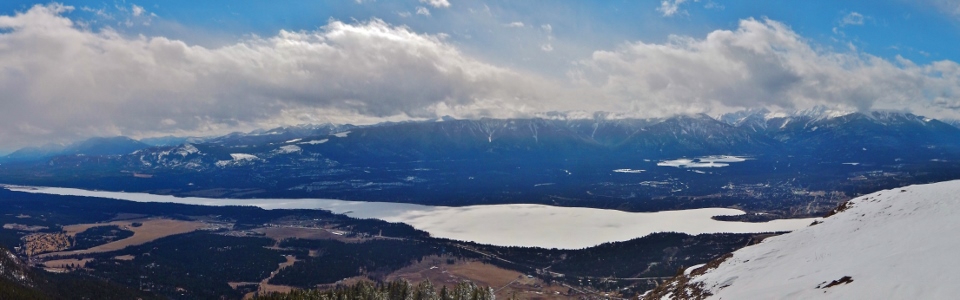
Panorama looking south along the western edge of the Canadian Rockies. Windermere Lake in the valley below with Columbia Lake visible in the distance. Click to see larger.
.jpg)
Pinto Mountain (right) to the northeast.
.jpg)
Summit couple shot before heading back down from whence we came.
.jpg)
Resume “post-holing”…
.jpg)
Once we had descended beyond the rock bands on the southwest face, we opted to forego climbing back up the outlier and, instead, took a more direct route down via a drainage. This drainage eventually led us back to the Swansea Mountain Road which we followed uneventfully to our waiting car at the trailhead.
.jpg)
Of course, no drive home from Invermere is complete without a stop at beautiful Radium Hot Springs; the perfect way to end a romantic mountain-filled weekend!
.jpg)
.jpg)
.jpg)