Mount Bogart’s picturesque pyramid-shaped summit is one of the loftier peaks visible from Calgary. Despite its prominence and aesthetic appeal, I had very little desire to climb this peak after studying the description of the route up its south face in Alan Kane’s Scrambles guidebook. Perhaps it was Kane’s description of the route as being “long and uninspiring”; perhaps it was the 11 km approach hike to Ribbon Falls before the ascent even begins; perhaps it was the “hours slogging up treadmill scree”; perhaps it was the 1650 m elevation gain required or perhaps it was the myriad of internet trip reports which made the peak sound generally unpleasant. Shocking that the peak was not high on my “to-do” list for so long, I know!
Well, all that changed when I saw the description of an alternate ascent route up the peak’s west ridge in Andrew Nugara’s follow-up “More Scrambles” guide. This route was both shorter (only a 5 km approach is required) and required less elevation gain (1400 m) than Kane’s. More importantly, the west ridge looked airy and exhilarating compared to the loose scree slope that Kane recommends on the other side! While I was certain that the west ridge would provide a more entertaining ascent, I was somewhat hesitant to commit to an attempt knowing that many of the routes described in Nugara’s book are technically challenging; the west ridge looked so damned intimidating that I had a hard time imagining that a moderate route could be found upon it! After contemplating the ascent for a couple of years now, I finally decided to give it a go! I left Calgary solo at 4:30 am hoping to be up, down and back home in time for kickoff of the Stampeders game that night (4:30 pm). Much like Nugara (who also climbed Bogart’s west ridge with a time constraint upon him), I must have been delirious to think that I’d be home in time. No matter, if I wasn’t delirious before the attempt, I was when I saw the spectacular panorama from the summit!
.jpg)
An inspiring start to the day: a herd of elk graze below Mount Lady McDonald at sunrise. With no other traffic at this hour, I stopped to watch them for 10 minutes, listening as the calves peculiar cries broke the morning silence.
.jpg)
After continuing my commute to the “Sparrowhawk” parking area on the Spray Lakes Highway, I started up along the pleasant hiking trail towards the Sparrowhawk Tarns. After hiking through the forest for several km, the views to the west (including sun-splashed Old Goat Mountain) suddenly opened up.
.jpg)
The trail to the Sparrowhawk Tarns begins just to the south of the “Sparrowhawk” parking area. After about 10 minutes, the trail branches with the left fork leading towards Mount Sparrowhawk and Read’s Tower while the right fork leads towards the Sparrowhawk tarns. As the forest began to thin, the trail enters the large boulder field pictured. From here, cairns guide you up good trails on the grassy slopes to the right.
.jpg)
No boulder field is complete without a Mohawk-ed marmot.
.jpg)
After a shady and cool hike in, the sun finally rises above the steep rock face extending to the north of Mount Bogart.
.jpg)
The trail to the Sparrowhawk Tarns culminates in this pristine alpine amphitheater tucked between Mount Sparrowhawk, Mount Bogart and Red Ridge.
.jpg)
With only faint trails here and there, I made my way directly across the open alpine meadows, following this mossy stream to its source, the Sparrowhawk Tarns, above.
.jpg)
From the tarns, the fun begins in earnest. This scree ramp (southeast of the tarns) provides access to Bogart’s west ridge (top left). The terrain on the ramp is very steep and VERY loose (a common theme on Mount Bogart, it seems). With 30 degree Celsius temperatures and clear skies forecast, I was not looking forward to the 300 vertical m grunt up this slope. Mercifully, it was still in the morning shade!
.jpg)
While the slog up the scree ramp was thoroughly unpleasant, the improving views of the Sparrowhawk Tarns in the cirque below provided the inspiration necessary to persist through the perspiration. Click to see larger.
.jpg)
At the top of the scree ramp, easier terrain leads quickly up to a sub-summit of Mount Bogart. From there, the panorama was spectacular with Red Ridge (left) and Mount Sparrowhawk (right) bookending the beautiful tarns below. Beyond the alpine cirque, Spray Lake meanders along the length of the valley. Click to see larger.
.jpg)
Looking beyond a tarn up the Spray Valley towards the Bow Valley, Canmore and Banff.
.jpg)
Bow Valley landmarks: Mount Rundle (left) and the Big Sister (right).
.jpg)
Mount Bogart (left) towers above the sub-summit and an alpine basin below. Kane’s route directly ascends scree slopes from this basin while Nugara’s route tackles the connecting ridge. The peaks of the Kananaskis Valley provide a beautiful backdrop. Click to see larger.
.jpg)
Another tarn in the basin below.
.jpg)
The jagged peaks of the Opal Range jut upwards through the summer haze. Mount Evan Thomas is the highest peak on the left while Mount Rae is the most distant peak visible in the center.
.jpg)
At the sub-summit, I took a long break to refuel, take photos and assess the remainder of the route up Mount Bogart’s west ridge. As feared, the west ridge looked fairly intimidating! Not wanting to take any foolish risks solo, I actually contemplated aborting the attempt and simply enjoying the sub-summit for quite some time. Eventually, however, I convinced myself to give the ridge a go. I promised myself that I wouldn’t do anything sketchy and would turn back if the terrain ever became difficult. I’m pleased to report that, despite appearances, the west ridge is indeed a (reasonably) enjoyable moderate scramble and much less exposed than it appears. Don’t let the scary view from the sub-summit deter you!
.jpg)
Bogart and I.
.jpg)
From the sub-summit, one has to down climb a series of small rock bands. On descent, I avoided re-ascending these by side-sloping on the left (despite Nugara’s warnings not to).
.jpg)
The break in the rock band that I down climbed to reach the west ridge proper.
.jpg)
The hot summer sun is now high in the sky as I reach the slabby start of Bogart’s west ridge. Although the slab appears narrow from a distance, it’s actually wide enough to drive a car up in most places! Ahead, a blocky outcrop obstructs the ridge leading to the pointy summit beyond. Skirting this outcrop is the crux of the ascent.
.jpg)
At the base of the rocky outcrop. Although Nugara suggests that you can climb the outcrop, it was slightly overhanging in most places, and this was not an appealing option to me. Instead, I by-passed it by following a scree ledge on the climber’s right.
.jpg)
The scree ledge by-pass is quite wide in most places, however, it is steep and the terrain was quite loose. At one point, the ledge narrows but never to the point of becoming exposed. While the scrambling involved is moderate at most, you should be sure to check every hand hold before committing!
.jpg)
Beyond the blocky outcrop crux, a second slab sidewalk leads to Bogart’s summit block. Like the first section of slab, this one is wider than it looks from afar. Near the top, a small notch is easily down climbed (again, easy moderate scrambling) before regaining the ridge from the climber’s right a few meters above. A series of rock bands along the ridge just below the summit make it appear as though you may need to detour to the right, however, easy ways up become apparent the closer you get to them. I managed to follow smatterings of a trail and stayed on (or very near) the ridge the entire way.
.jpg)
Mount Sparrowhawk and Mount Lougheed beyond a slabby rock garden.
.jpg)
Above the rock bands, the summit is only a minute away. Once there, you’ll be treated to an absolutely spectacular panorama! Click to see larger.
.jpg)
A sea of peaks stretches out to the south beyond the summit cairn. Familiar Kananaskis peaks such as Mount Kidd, the Fortress and Mount Galatea eventually give way to the larger glaciated peaks of the continental divide beyond.
.jpg)
Ribbon Falls and Ribbon Lake far below.
.jpg)
The tarn and alpine basin from which the Kane route ascends.
.jpg)
Enjoying a cloudless day from the second highest point in the Kananaskis Range!
.jpg)
Red Ridge and Mount Buller separate Mount Bogart from Spray Lake. "Baby Buller" is the outlier to the right of Mount Buller.
.jpg)
Mount Eon (left), Mount Aye (center) and Mount Assiniboine (right) highlight the view to the west beyond Mount Turner (left) and Cone Mountain (right).
.jpg)
The highest peak in the southern Canadian Rockies: Mount Assiniboine.
.jpg)
Clear skies beyond Mount Eon granted views as far as Mount Alpha Centauri in the Purcell Mountains.
.jpg)
11,000ers dot the horizon to the west. Click to see larger.
.jpg)
Glaciated Mount Joffre beyond the sheer north face of the Fortress.
.jpg)
Mount French dwarfs Mount Murray to the left of Mount Galatea while Mount Sir Douglas dwarfs Mount Burstall on the right.
.jpg)
Mount Queen Mary beyond the Tower.
.jpg)
Mount Queen Mary.
.jpg)
Striking Shark Fin Peak and Mount Soderholm beyond Mount Smuts and Mount Engadine (foreground).
.jpg)
Looking over Mount Bogart’s snowy east face towards Ribbon Peak (left), Mount Kidd (center right) and the Kananaskis Valley. Click to see larger.
.jpg)
Snowy Fisher Peak beyond the north face of Mount Kidd.
.jpg)
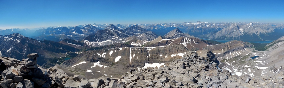
The grey limestone of the Kananaskis Range stretches out to the north while smaller front range peaks and the Memorial Lakes below provide a splash of color to the east. From left to right: the Big Sister (distant), Mount Sparrowhawk, Mount Lougheed, Wind Mountain, the Bogart Tower (diminutive), Mount Allan, Mount Collembola, Mount McGillivray, Skogan Peak, Mount Lorette, Mount Baldy (distant), Ribbon Peak (foreground) and Wasootch Peak. Click to see larger.
.jpg)
Taking in the view.
.jpg)
The spectacularly steep south face of Mount Sparrowhawk.
.jpg)
Goat Mountain and Mount Yamnuska provide a final barrier to the prairies beyond Mount Allan and Mount Collembola.
.jpg)
The Memorial Lakes surround the Bogart Tower.
.jpg)
Back to the breathtaking western panorama featuring the Sparrowhawk Tarns on the left and the Memorial Lakes on the right. Click to see larger.
.jpg)
Mount Nestor (left) and Old Goat Mountain (right) across Spray Lake.
.jpg)
Distant but familiar peaks (including the Goodsir Towers, Mount Vaux and Mount Ball) visible beyond steep terrain on Old Goat Mountain.
.jpg)
First ascent of 2014 according to the register! By this time it was nearly 1:00 pm and, in the absence of a conveniently placed zipline, it became apparent that I would not be home in time for kickoff of the Stamps game (4:30 pm). Oh well, that’s what PVRs are for!
.jpg)
Enjoying the sun and the sea of peaks.
.jpg)
Last views from the summit before reluctantly pulling myself away from the amazing scenery to begin my descent.
.jpg)
Looking down the west ridge descent route towards the sub-summit. Time to retrace my steps before running out of drinking water!
.jpg)
After carefully descending the ridge, I found myself back at the col above the scree ramp within an hour.
.jpg)
Looking back at the aesthetic west ridge for the last time before scree bashing back down the ramp.
.jpg)
By this time, it was 33 degrees Celsius and the Sparrowhawk Tarns below were calling to me! Fortunately, the descent down the scree ramp was much more pleasant than the ascent with good scree skiing interrupted occasionally by small rock bands for variety. I even managed a 100 m glissade near the bottom!
.jpg)
The quickest way to cool off (sorry to any strangers who ended up seeing my pale white ass in the tarn)!
.jpg)
Refreshed from my dip in the icy tarn, the views of Mount Bogart provided a satisfying sense of accomplishment.
.jpg)
The hike out over wildflower-spotted alpine meadows provided a scenic end to an amazing day in the Rockies. Considering the numerous unpleasant accounts of ascending Bogart via the Kane route, I’m shocked that more people don’t go up via the Nugara route (the register suggested that the vast majority of ascents take place from Ribbon Creek)! Despite its intimidating appearance, the west ridge provides a scenic, shorter and more enjoyable way to the top. Compared with other “moderate” Kananaskis scrambles (Mount Kidd, Mount Lawson, the Tower, Mount Rae,Storm Mountain etc.), I would say that the Nugara route up Bogart is comparatively easy!
.jpg)
.jpg)
.jpg)
.jpg)
.jpg)
.jpg)
.jpg)
.jpg)