Midnight Peak Attempt
Elevation: 2340 m
Elevation Gain: 950 m
Midnight Peak is the unofficial name of the double-peaked mountain immediately to the south of Baldy Pass. The peak was named following an incident in which a group of Rocky Mountain Ramblers attempted to descend via an alternate route. Their choice left them stranded atop cliffs and although they ultimately made it down safely, they did not reach their cars until midnight.
My Attempts:
January 25 2014
Trailhead: Baldy Pass Trailhead
GPS Track: Midnight Peak Attempt
Seeking to take advantage of the unseasonably pleasant weather, I set in motion a plan that I hoped would place Grant and I (and Crux) atop Midnight Peak on a beautiful January day. Step 1 of the plan involved stealing borrowing a couple of pairs of snowshoes from my sister in law. Step 2 involved gathering beta (GPS tracks etc.) from Doug Lutz who had ascended the peak a little over 1 month earlier. I knew of several possible routes to the top and decided to make my ultimate choice on the fly once we were at the peak’s base and I could assess the snow conditions for myself. Step 3: climb the damned thing. Regrettably, we never did manage to cross step 3 off of the to-do list…
.jpg)
We arrived at the signed Baldy Pass trailhead shortly before sunrise and started our approach to the peak using the flood-damaged Baldy Pass trail. Despite the destructiveness of June’s floods, the trail was completely navigable provided that you were able to keep yourself from falling into random washouts like the one pictured here. Indeed, the path appears to have been somewhat popular this winter and we were able to follow an excellent broken trail. Based on Doug’s GPS track, I knew that his party had ascended Midnight’s west ridge, leaving the Baldy Pass trail less than 2 km from the parking area. When we arrived at this point, I was disappointed to see that their old snowshoe track was significantly less defined than the well-trodden Baldy Pass trail. Opting for the lazier of 2 options, I decided to follow the hard-packed trail 4 km to Baldy Pass and attempt to ascend via the mostly windswept north ridge. In retrospect, the north face would turn out to be not quite windswept enough and this decision early on in the day would keep us from reaching the summit.
.jpg)
Looking back as the early morning light illuminates Mount Bogart from the Baldy Pass trail. All of the views on this trail are at your back as you hike in so be sure to turn around from time to time otherwise you’re in for a dull 4 km hike!
.jpg)
The north face/ridge of Midnight Peak from Baldy Pass. Looks pretty windswept, right? Unfortunately in this instance, appearances were deceiving. We followed the broad ridge line and ended up topping out just above the highest of the trees seen in this photo before being thwarted by, what we considered to be, an unacceptable avalanche risk a mere 180 m below the summit.
.jpg)
Improving views of the Mount Baldy “massif” and the prairies from the top of the first clearing seen in the last photo.
.jpg)
Crux waits patiently while Grant and I get the snowshoes on. While the clearings were largely windswept, the treed areas were filled with knee – waist-deep unconsolidated sugar snow which offered the highest quality of suffering imaginable.
.jpg)
A severe case of foreshortening. Although the summit looked close from this clearing, it would take us 30 minutes to break trail through the patch of trees ahead, gaining only 80 vertical meters from where this photo was taken in the process.
.jpg)
Enjoying a last glimpse of the sunny Kananaskis Valley from the clearing before plunging back into the trees. Another consequence of choosing to ascend via the north face/ridge was the fact that we would be plagued by shade the entire time.
.jpg)
Crux taking a turn breaking trail (his turn did not last long).
.jpg)
Grant topping out above the trees after 30 profanity-filled minutes. Unfortunately, this is where our ascent came to an end on this day.
.jpg)
It may look somewhat innocent in this photo but this is the slope that put a stop to our day. It was probably only 40 feet to reach the safety of the windswept rocks but an ap on my cell phone confirmed that this wind-loaded slope’s angle was 35 degrees. This coupled with the long run-out below the traverse and the unstable snowpack (2 – 3 inches of wind slab atop 2 feet of sugar snow) made the decision to turn around elementary.
.jpg)
A better view of the steep wind-loaded terrain at our stopping point. At least we finally got to the feel the sun on our faces after nearly 4 hours of hiking in the shade!
.jpg)
All was not lost, however. The steep slopes above the tree line did, at least, offer a spectacular view of the front ranges!
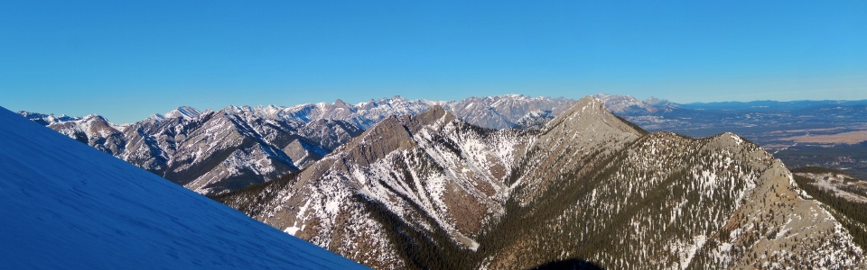
.jpg)
A wintery front range panorama. Note Midnight Peak’s shadow cast over the approach valley below. Click to see larger.
.jpg)
Mount Fable beyond Mount Baldy.
.jpg)
Grotto Mountain (distant right) also makes an appearance.
.jpg)
Whatever doesn’t kill you only makes you stronger (and in this instance wiser). Next time, I’m following the west ridge ascent route no matter how tempting the good trail to Baldy Pass is!
.jpg)
Time to head back down. Failed summit attempts make for a sad puppy.
.jpg)
Great views of Mount Lougheed and Mount Lorette from lower down.
.jpg)
Crux making the shady walk back out from Baldy Pass towards a sunny Nakiska across the Kananaskis Valley.
.jpg)
Winter wonderland.
.jpg)
A cut line near the trailhead grants us 1 final view of Mount Lorette.
.jpg)