McGillivray Ridge
Elevation: 2330 m
Elevation Gain: 570 m
Originally named “Bullhead”, McGillivray Ridge was renamed in honor of Donald (Dan) McGillivray. McGillivray was a self-taught engineer and contractor who specialized in railway construction. Although he was involved in many significant projects with the Canadian Pacific Railway, his last involved the construction of a challenging 65 km stretch of railway in the Crowsnest Pass. Today, this rail line is still in operation immediately to the south of McGillivray Ridge.
My Ascents:
May 18 2014
Trailhead: McGillivray Ridge Parking (Roadside)
“In this world, nothing can be said to be certain except death and taxes.”
-Benjamin Franklin, 1789.
Hundreds of years after Franklin’s famous quote, I believe that we’ve found another constant to accompany death and taxes in their infamy: crappy May long weekend weather in the Rocky Mountains. Without fail, one can count on overcast conditions highlighted by rain and, often, snow on what is supposed to be the long weekend that provides the informal kickoff to summer. The 2014 edition of Victoria day was, of course, no different. Despite the poor forecast for most regions of the Rockies, however, a faint ray of hope could be seen shining through the gathering storm clouds in the far southwest corner of Alberta where the Crowsnest Pass forecast called for light rain and perhaps even a chance of sunshine (GASP)! With visions of blue skies and sun beams dancing in our heads, we set out on the longish 2.5 hour drive south to see if we could bag a peak while feeling the sun’s warmth on our pale Canadian skin after a long, COLD winter.
.jpg)
With the larger peaks still covered in snow, we set our sights on a smaller shoulder season target in the front ranges. Having noted McGillivray Ridge’s proximity to scenic Crowsnest Mountain, I hoped that this small ridge would provide big views!
.jpg)
Thanks to an above average snowpack and a cool spring, the standard parking area at the unmarked McGillivray Ridge trailhead was underwater…
.jpg)
…we, therefore, parked 750 m further back along Highway 40 at the intersection shown (9.5 km after leaving Highway 3).
.jpg)
After making our way back along the road to the soggy trailhead, we started our outing with some high quality suffering by post-holing through knee-deep, heavy, wet snow. Clearly my parents should consider thinking twice about leaving the selection of family hikes to me…
.jpg)
The steep, snowy cutline that leads up McGillivray Ridge. Impressively, it was actually steeper than it looked from here!
.jpg)
Breaking trail for the folks.
.jpg)
Elders in alders: a bushy diversion that proved no easier than post-holing through knee-deep snow.
.jpg)
After the steep, snowy grunt up the cut line, we found ourselves on more gentle and open alpine terrain. In the center-right of the photo, you can make out an old road used to service a repeater on the central bump above. Although the described hiking route follows the road, we found it easier (and more scenic) to simply follow the gentle ridge to the right.
.jpg)
Pleasant views of the Livingstone Range; this is more in line with what mom signed up for!
.jpg)
Improving views of the Flathead Range to the south.
.jpg)
The Flathead Range (from left to right): Mount Coulthard, Mount McLaren, Andy Good Peak, Mount Parrish, Mount Ptolemy and Chinook Peak.
.jpg)
A spectacular view of a spectacular peak! Crowsnest Mountain steals the show to the west!
.jpg)
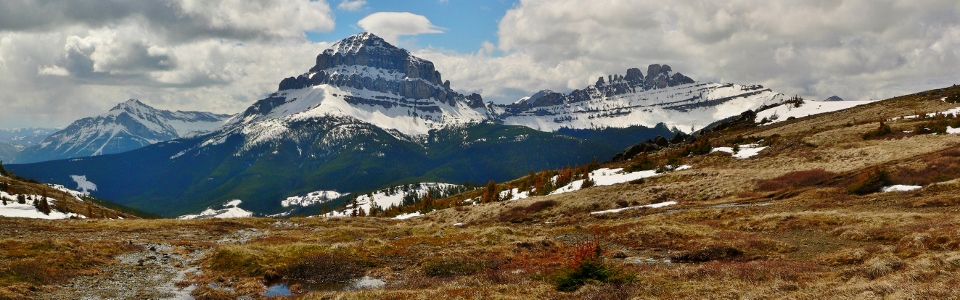
Once on the ridge, even mom agreed that this panorama was worth post-holing for! From left to right: the Flathead Range, Mount Tecumseh, Crowsnest Mountain and the Seven Sisters. Click to see larger.
.jpg)
All seven of the aforementioned sisters.
.jpg)
The family that post-holes together…
.jpg)
That’s one happy dog!
.jpg)
Gaining the upper ridge crest required one final trip through the knee-deep snow.
.jpg)
Enjoying a break on the colorful ridge crest.
.jpg)
An annoying boulder field leads to the slightly higher northern end of McGillivray Ridge. Ma Butte can be seen on the left while the High Rock Range stretches out towards Kananaskis Country.
.jpg)
A closer look at Ma Butte.
.jpg)
Gould Dome (foreground) and Tornado Mountain (background) highlight the view of the High Rock Range to the north.
.jpg)
The view to the south from the high point. Although the next bump to the north is marginally higher, we opted to stop at this cairn in light of approaching weather.
.jpg)
Enjoying the view of Crowsnest from the top.
.jpg)
A sizeable cornice guards the eastern flank of the ridge higher up. Turtle Mountain to the left and the Castle Wilderness beyond to the south.
.jpg)
A closer look at Turtle Mountain and Frank Slide. Mount Cleveland (highest peak on the left) and Castle Peak (directly behind Turtle Mountain) are easily discernable in the distance.
.jpg)
The Livingstone Range beyond the summit cornice.
.jpg)
They might not have been smiling while they were post-holing below but with views like this it’s hard not to grin.
.jpg)
First summit of the year with mom.
.jpg)
As the threatening weather approached from 3 different sides, we opted to beat a hasty retreat!
.jpg)
No need to self-arrest when Crux is there to stop you!
.jpg)
The best views of the day: Mount Tecumseh, Crowsnest Mountain and Seven Sisters Mountain as seen from near the repeater. Click to see larger.
.jpg)
The damned Old Man (not to be confused with the nearby Old Man Dam).
.jpg)
What a beauty!
.jpg)
Despite a chilling wind, Crux still felt the need to cool off.
.jpg)
♫ On the road again ♫
.jpg)
The tick magnet taking a break before the steep descent down the cutline.
.jpg)
How steep is the cutline? VERY.
.jpg)
The best way down the steep snow! Following a very enjoyable glissade, we were back at the trailhead in no time. All in all, McGillivray Ridge proved to be a very scenic shoulder season outing!
.jpg)
.jpg)