Little Lougheed Attempt
Elevation: 2480 m
Elevation Gain: 780 m
Little Lougheed is a small outlier on the Mount Lougheed massif which encompasses 5 higher peaks. Despite its comparatively diminutive stature, Little Lougheed is very well situated from a scenery perspective.
My Attempts:
April 5 2014
Trailhead: Spencer Creek (Roadside)
GPS Track: N/A.
With the forecast finally improving (what is it with this winter?), I was once again chomping at the bit to get out to the mountains for an outing. Due to a commitment to attend a baby shower that afternoon (congrats Kyrsten and Mike!), however, I needed to get underway at a very early hour and had to select a reasonably short outing. Complicating matters, the avalanche danger spiked from “moderate” to “considerable” overnight; conservative route choices, therefore, became a must. After seeing a recent trip report which indicated that the route up scenic Little Lougheed had surprisingly little snow, I decided to make my way to the unsigned Spencer Creek trailhead in the early hours of the morning.
.jpg)
One of the benefits of an alpine start! A spectacular sunrise on the Rockies. The view was so good that I exited the highway and navigated a series of dirt roads looking for the perfect spot from which to snap some photos.
.jpg)
Sunrise panorama. Mount Bogart on the far left (in the clouds), Mount McGillivray in the center and Mount Lougheed (behind which lies the day’s target Little Lougheed) on the far right. Click to see larger.
.jpg)
Spectacular alpenglow on the Three Sisters. After amusing myself with my camera on the side of a dirt road for several minutes, I begrudgingly made my way back to the highway and continued onwards to the trailhead at Spencer Creek.
.jpg)
The trailhead at Spencer Creek is not marked, nor is there any roadside pullout or parking area. You simply park on the side of the road 2.8 km south of Spurling Creek. This is the same trailhead that you can use to access the scramble route up much larger Mount Lougheed. Moments after leaving the road, you should come across a mossy spring (which surprisingly continues to flow during the winter). This spring lets you know that you’re on the right track. To access Little Lougheed, you begin to ascend a treed ridge to the left shortly after passing this spring. The route up Mount Lougheed continues to follow the drainage upwards to the headwaters of Spencer Creek.
.jpg)
Although I was able to follow an old snowshoe track through the woods, as the terrain became more open, the wind had erased any trace of it from the landscape. As the avalanche forecast had warned, this same wind also deposited a nasty crust atop a very deep layer of less consolidated snow. Here Crux demonstrates the post-holing technique which had me exchanging choice words with the mountain as the terrain steepened. The ascent was exhausting and, in many places, my 4 foot pole easily penetrated the entire snow pack without touching ground underneath.
.jpg)
Arriving at the boulder field amidst cloudier skies than forecasted.
.jpg)
Crux takes a well-earned break following his post-holing endeavors.
.jpg)
Mount Sparrowhawk provides an impressive backdrop as the terrain steepens.
.jpg)
Crux’s ears perk up at the alarming sound of a series of “WUMPHS” as the snow pack settled beneath our feet. Given the “considerable” avalanche danger, this marked the end of our attempt. We quickly retreated to more stable ground, enjoyed a cup of tea (well, I did anyways) and made our way back towards the car. At least we wouldn't be late for the baby shower!
.jpg)
Although we were nowhere near the summit, the open area of the boulder field where we aborted our attempt still provided plenty of scenery. The Big Sister and Spray Lake fill up the scenery to the northwest.
.jpg)
Mount Nestor (left) and Old Goat Mountain (right) across Spray Lake. The trailhead where Spencer Creek meets the highway visible in the foreground.
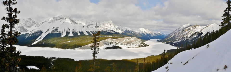
.jpg)
Spray Lake panorama. No summit on this day but I’ll be back…click to see larger.
.jpg)
The weather deteriorated once I was back down to the trailhead as clouds swept in and snow began to fall…so much for the sunny forecast. The massive peaks of Mount Lougheed I and Mount Lougheed II are still just visible to the left and right, respectively. Framed nicely in the center is Little Lougheed. As it grew colder and the clouds obscured the views, I became more and more satisfied with my decision to postpone this summit for a safer (and hopefully clearer) day!
.jpg)
.jpg)