As has been the case too often this summer, my Friday off of work once again coincided with an unsettled weather forecast. My original intent for the day had been to tackle a short moderate scramble solo so as to be home in time for dinner with the wife Boss. As I readied my pack and boots, however, Crux stirred from his kennel and set his big brown puppy dog eyes towards me wondering why I was getting my hiking gear ready and not his.
Unable to ignore the puppy dog eyes, I made the last minute decision to bring Crux along. I hadn’t spent any time thinking of nearby puppy-suitable objectives but recalled a recent Marko Stravic trip report for “Picklejar Peak” which, upon first thought, met the requirements of being both nearby and non-technical. Unfortunately, the whole plan turned out to be poorly conceived and, upon hiking to the end of the fourth Picklejar Lake, the scree route up “Picklejar Peak” looked like it would amount to animal cruelty.
Wanting to salvage a summit still, I decided to investigate Lineham Ridge on the hike back out from Picklejar Lakes. I knew that the peak was rated moderate but could recall little else from Andrew Nugara’s description and hoped that Crux and I might be able to route-find a puppy-friendly way to the top. Unfortunately, this plan was also somewhat poorly conceived…
.jpg)
Crux checks out the state of Lantern Creek following last year’s devastating floods. Although the creek bed was heavily damaged, the popular trail to Picklejar Lakes (which starts at the Lantern Creek day use area) was, fortunately, spared.
.jpg)
Early views of Lineham Ridge from the Picklejar Lakes trail. The trail contours the left-hand hillside aiming towards the col left of Lineham Ridge. The lakes themselves lie on the other side. At this point, we were still planning to ascend “Picklejar Peak” and were unaware that Lineham Ridge would be our ultimate destination.
.jpg)
Crux pulling me up the steep grassy slopes which lead to the col.
.jpg)
At the col, we broke through the tree line and were treated to our first views of Mist Mountain and other larger nearby peaks.
.jpg)
“Aren’t you happy that you didn’t leave me at home?!”
.jpg)
The descent from the col towards the Picklejar Lakes was damaged by the floods, however, a good trail has already been re-established: a testament to the popularity of these scenic little lakes. Click to see larger.
.jpg)
A calm morning at the first Picklejar Lake.
.jpg)
Thanks to an alpine start, the first lake was glassy calm and reflected the surrounding peaks beautifully. The only ripples were those caused by a certain canine who decided to go for an early morning dip.
.jpg)
Once I extracted Crux from the first Picklejar Lake, we hiked beyond the second lake (which isn’t really photo-worthy) to the third (and in my opinion prettiest) lake. At this point, the route up “Picklejar Peak” is still hidden out of sight at the back of the amphitheater to the right. Click to see larger.
.jpg)
Trying to capture the reflections in the lake before Crux decides to go for another swim.
.jpg)
After working our way around the south shore of the third Picklejar Lake, the route up “Picklejar Peak” finally came into view. Three scree ramps are obvious on the center right and the route up follows the ramp in the center. Although the route was clearly non-technical, I hadn’t considered the fact that it would involve over 500 vertical meters of steep scree and decided that Crux’s paws should probably be spared from this ugliness. It was at this point, that I decided to retrace our steps towards the col above Picklejar Lakes and investigate the (hopefully) more solid route up Lineham Ridge.
.jpg)
The panorama from the third Picklejar Lake was quite pretty as we made our way back along its south shore and, probably would have been a good place to enjoy a snack and call it a day. Click to see larger.
.jpg)
After making our way back along the Picklejar Lakes trail, Crux and I worked our way up flood-damaged terrain to gain the lower flank of Lineham Ridge at the grassy col above. Although this terrain looked fairly benign from below, ascending it involved a great deal more side-hilling than anticipated (this would turn out to be a common theme on this day).
.jpg)
The view to the west from the grassy col revealed increasing cloudiness and a cool breeze hinted at deteriorating weather.
.jpg)
Working our way up along the ridge was both easy and rewarding at first as we were granted wonderful views of the Picklejar Lakes directly below.
.jpg)
Easy travel along the ridge. Above, where the ridge crest sharpens and becomes slabbier, Crux and I were able to route-find our way along good grassy ledges below the crest to the climber’s right…for a time, anyways.
.jpg)
Continuing along ledges below the ridge crest, the summit (or what I presumed was the summit) eventually came into view. Unfortunately, by this point, the ledge system which Crux and I had been taking advantage of was interrupted by a series of rock bands. Although these were moderate in nature, they were beyond the scope of what Crux could reasonably be expected to ascend. The ridge crest itself appeared to offer fine moderate scrambling in most places, however, the level of exposure was also greater than what I was willing to subject Crux to. But the summit looks so close…
.jpg)
Not my proudest moment: the temptation of the nearby summit proved too much for me. I found a nice grassy spot for Crux and tied him to a small but sturdy tree there and then proceeded to make as quick an attempt on the summit as I could. Looking back, I’m very sorry that I did this; I care a lot more about my dog than I do about any summit and it really eats at me that I made this decision. Sorry Mr. Crux.
.jpg)
The ledge system that Crux and I had been using led me to down climb this rock band (the main reason that Crux couldn’t continue along). From here, I quickly groveled up the loose gully above, regaining the ridge crest and scrambling to the “top” in about 15 minutes.
.jpg)
Looking back along the moderate ridge from the “top”. For the most part, the ridge was only mildly exposed and more exposed steps could generally be by-passed to the climber’s right (left in this photo).
.jpg)
The cloudy summit panorama to the west. From left to right: Mount Loomis, Mount Odlum and Storelk Mountain form high points along a continuous rock wall, Mist Mountain, Mount Rae, the distant Opal Range, Highwood Peak, the fourth Picklejar Lake and Junction Mountain. Click to see larger.
.jpg)
Mist Mountain living up to its name.
.jpg)
Mount Rae (left) and the jagged peaks of the distant Opal Range (right).
.jpg)
Outliers of Highwood Peak to the north.
.jpg)
Junction Mountain and the prairies beyond to the east.
.jpg)
Panorama to the south including “Picklejar Peak” (left) and the High Rock Range (right). Click to see larger.
.jpg)
“Picklejar Peak” and a slightly higher point along Lineham Ridge to the east. When I arrived at what I thought was the summit, I was dismayed to see a slightly higher point another 10 minutes along the ridge. With Crux waiting for me, there was no way that I was going to spend any more time dicking around on the ridge, so I decided that “enough was enough” at the false summit.
.jpg)
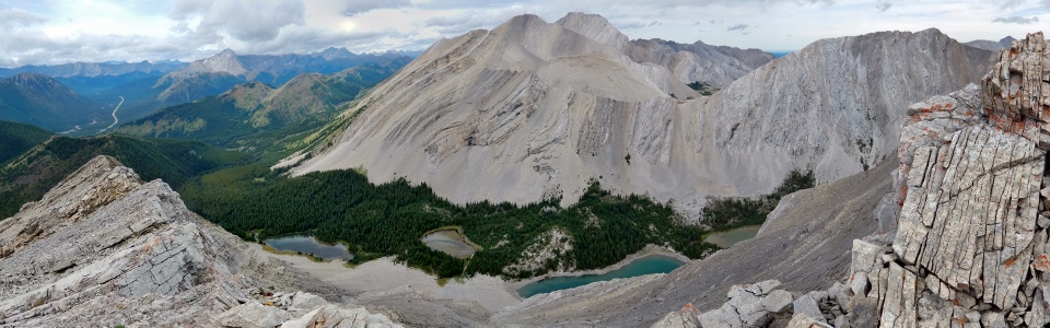
The all-four-Picklejar-Lakes-panorama. Click to see larger.
.jpg)
Sweaty summit selfie after ascending as quickly as I could.
.jpg)
After a very short summit stay, it was time to retrace my steps along the mildly exposed summit ridge towards my patient puppy below.
.jpg)
♫ Reunited and it feels so good! ♫ About half an hour after leaving him, I found a very happy Mr. Crux waiting for me; truth be told, I’m not sure which one of us was happier to see the other.
.jpg)
Rather than retracing our steps along the grassy ledges that we’d ascended, Crux and I took a more direct line straight down grassy slopes (pictured). Unfortunately, once we were down, this forced us into a significant amount of grassy side-hilling to regain the Picklejar Lakes trail.
.jpg)
A butterfly admires the fall colors.
.jpg)
Back on the scenic trail and making good time now that the side-hilling is finally over with! The day didn't pan out exactly as planned but, at least, I was still home in time for dinner!
.jpg)
.jpg)
.jpg)
.jpg)
.jpg)
.jpg)