With the Rocky Mountains still surprisingly dry, many scramble routes were still in unusually good condition over the Thanksgiving long weekend. In analogy to farmers who must seek to “make hay while the sun shines,” compulsive scramblers must “bag peaks before the snow flies!” And so, with an eye towards summits and suffering, I managed to convince Aurore to get out of bed much earlier than she would have liked on her Saturday morning and we made our way along familiar highways into beautiful Kananaskis Country.
While we had originally been targeting a peak in the Opal Range, we were dismayed to turn a corner on Highway 40 and to see that the entire Opal Range was obscured by thick, malevolent-looking cloud. Damn – time for “plan B!” With the weather looking unsettled all about, we back-tracked a couple of minutes and parked at Wedge Pond (where our cell phones would work again). Taking advantage of the cell phone reception present, we checked various mountain webcams to assess weather conditions in other areas. Unfortunately, most of these webcams showed more of the same: low-lying cloud and unsettled conditions. As we discussed options, we noted that the skies surrounding 3000 m tall Gusty Peak, which was framed nicely by my windshield from our parking spot, remained clear and cloud-free. Gambling that Gusty would stay that way, we called an “audible” and made haste towards the recently rebuilt Chester Lake trailhead which serves as Gusty’s starting point.
.jpg)
Following a popular 4.6 km long hiking trail, we quickly arrived at Chester Lake and were granted a good view of Gusty Peak beyond the lake to the north.
.jpg)
Aurore happily hikes up the headwall behind Chester Lake.
.jpg)
As we hiked up the valley towards the Fortress, we left Chester Lake’s alpine meadows behind and entered a rocky moonscape.
.jpg)
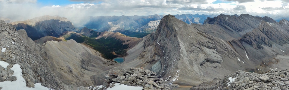
Near the BOTV (back of the valley), the routes for Gusty Peak (left) and the Fortress (right) separate once the tarn at the base of these peaks comes into view. Click to see larger.
.jpg)
The route up Gusty Peak follows the tilt of the rock strata diagonally from lower left to the summit on the upper right, making use of a long, loose scree ramp.
.jpg)
Looks fun, no? ;-)
.jpg)
Although the loose rubble ascent may be uninspiring, the panorama of the Fortress and more distant Mount James Walker across the valley more than compensate for the suffering. Click to see larger.
.jpg)
Thanks to the “Kane effect,” there’s an intermittent trail along the ascent ramp which we made use of whenever we were able to find it.
.jpg)
Aurore tops out on Gusty’s steep summit ridge as the weather begins to look less pleasant.
.jpg)
Once atop the ridge, Gusty's impressive summit panorama is just a short minute long walk away! From left to right: Mount Kidd's south summit, Mount Kidd, Limestone Mountain, the Wedge, Mount Fisher, Opal Ridge, the Fortress, Mount Denny, Mount Potts, Mount Evan Thomas, Grizzly Peak, Mount Packenham, Mount Hood, Mount Brock and Mount James Walker. Click to see larger.
.jpg)
Looking north along the Kananaskis Range towards (from left to right) Mount Sparrowhawk, Wind Mountain, Mount Bogart, the south summit of Mount Kidd and Mount Kidd.
.jpg)
The Fortress’ steep north face, complete with tarn and remnant pocket glacier at its base, continues to steal the show from the summit.
.jpg)
Mount Fisher (left), Grizzly Peak (center) and the Opal Range beyond the Fortress. The weather looks a little better over there than it did on the drive out!
.jpg)
A panorama of the Rocky Mountain moonscape to the west, highlighted by Mount Chester (left), Mount Galatea and the Tower (right). Click to see larger.
.jpg)
The unsettled weather creates some interesting lighting over Mount Chester and our rocky approach valley.
.jpg)
Looking west towards the massive peaks of the British Military Group. From left to right: Mount Smith-Dorrien, Mount Murray, Mount French, Cegnfs Peak, Mount Robertson, and glaciated Mount Sir Douglas.
.jpg)
A splash of sun on Burstall Pass and Mount Birdwood (right). Unfortunately, beyond this small patch of sunshine, the weather looked to be deteriorating all around us!
.jpg)
Now you see it, now you don’t! The inclement weather quickly moves in, darkening Mount Galatea’s steep face and obscuring the Tower all-together. Mouse over to see the difference that a minute makes in the Canadian Rockies.
.jpg)
Snapping a quick summit photo with the Fortress before retreating from the incoming squall. If it looks cold, that’s because it WAS! Gusty Peak more than lived up to its name on this day with a wind chill in the ball park of -15 C.
.jpg)
The squall moves up the valley as we retreat down the rubble. Note that this is actually a color photo; not black and white!
.jpg)
After a few frigid minutes, the sun begins to break through the blizzard.
.jpg)
Bright winter jackets and jagged rocky ridges.
.jpg)
Happy to have feeling back in her fingers (thanks to the hand warmers that someone donated…).
.jpg)
Aurore celebrates feeling in her fingers, sunny skies, a successful summit and (most of all) the fact the steep loose rubble is now behind us.
.jpg)
A pika-filled hike back towards Chester Lake. Eeeeeep!!!
.jpg)
Crashing a ptarmigan party.
.jpg)
Either the ptarmigan’s winter plumage arrived early this year or the snow is late.
.jpg)
Alpine meadows provide a soft spot for a rest after hours amidst the boulders.
.jpg)
Mounts Birdwood (center) and Smuts (right) provide a scenic backdrop as we make our way back down into the more colorful alpine.
.jpg)
Thanks to the multitude of fallen larch needles, the hike out felt like following the yellow brick road.
.jpg)
Let it snow? Please no!
.jpg)
Pastel colors in the alpine meadows below a misty Mount Chester.
.jpg)
After plodding back to the trailhead through the forest, Aurore and I celebrated another successful day of quality suffering in the mountains. While the plan had been to bag peaks before the snow flies, bagging a peak while the snow flew still proved enjoyable!
.jpg)
.jpg)
.jpg)
.jpg)