Another year older, another year wiser; so the saying goes but here I am still bagging peaks that subject my feet to painful, lengthy approaches! Since misery loves company, I decided to subject my entire family to the 18.6 km round-trip hike to Citadel Pass in honor of my DOB. Anyone eager to make their day a little longer and more painful was invited to join me for a quick jaunt up Citadel Peak from there! Knowing that the August long weekend would likely be busy, I booked bus tickets up to Sunshine Village for Brianne, myself, my parents and her parents weeks in advance. With a long day ahead of us, I was pleased that we were able to get on the first bus of the day, leaving the Sunshine Village parking lot at 8:00am. Unfortunately, this meant that Karen and Gary had to leave Okotoks at 5:30am; I took this as evidence that they really do love their son-in-law. Less keen on an alpine start, the clever Hobbs’ stayed in Canmore the night prior. While this had been intended to allow us to sleep in, having the Hobbs clan under the same roof so close to both my birthday and Gord’s resulted in a little too much celebration; as a result, I think the Hobbs’ eyes were blearier than the sleep-deprived Christisons on this particular morning! Since the best cure for a hangover is to hike, that’s exactly what we did following the 5 km bus ride up to Sunshine Village!
.jpg)
Starting the day at 2150 m elevation has its advantages, including this gorgeous alpine view a few minutes beyond Sunshine Village on the well-trodden Citadel Pass trail. The meadows here straddle the continental divide and are littered with western anemones and other wildflowers.
.jpg)
An expansive alpine meadow panorama featuring Quartz Hill on the left, Rock Isle Lake in the foreground and the Monarch on the center right. Our objective is about twice as far away as Quartz Hill - this is going to be a long day! Click to see larger.
.jpg)
A sharp outlier of Split Peak (right) provides an eye-catching highlight on the horizon.
.jpg)
Don’t be fooled by the 457 m “elevation gain” between Sunshine Village (2150 m) and Citadel Peak (2607 m). The rolling meadows separating the two contain a number of significant ups and downs making the total elevation gain for the ascent of Citadel Peak and return closer to 1040 m! These ups and downs may not look like much, but they add up!
.jpg)
A pleasant view of Mount Ball is revealed beyond wildflowers as we gain elevation up the left-hand flank of Quartz Hill. This high point along the trail was almost as high as Citadel Pass itself!
.jpg)
Looking east down the valley towards Banff from the high point near Quartz Hill. On the left, Mount Howard Douglas is visible in the foreground while Cascade Mountain can just be seen through the haze in the distance.
.jpg)
Telephoto of Banff landmark Cascade Mountain.
.jpg)
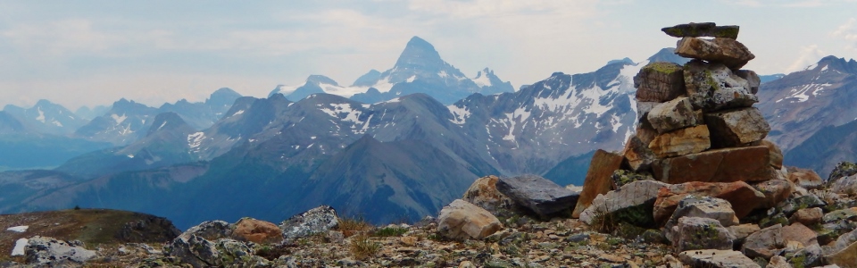
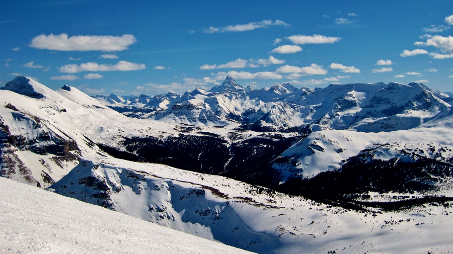
The high point also offers the first good views of our objective Citadel Peak (center left) and the more distant Matterhorn of the Rockies: Mount Assiniboine (right). This whole scene certainly looks different in the summer than it does in the winter!
.jpg)
From the high point, the trail descends to Howard Douglas Lake. It was unexpectedly hot at this point and swimming here on our way back was discussed. By the time we returned, however, the heat was no longer an issue.
.jpg)
While the first 4 – 5 km of meadows were dominated by western anemones, the wildflower display became more colorful and prolific the further that we hiked.
.jpg)
Beautiful asters.
.jpg)
A vibrant Indian Paintbrush.
.jpg)
Getting closer…Citadel Peak and Pass (left side of the peak) finally within striking distance!
.jpg)
Rounding the northeast end of the peak to Citadel Pass – almost there!
.jpg)
After a hot hike to Citadel Pass, Karen did Crux (who sadly was not allowed on the bus) proud by promptly cooling off in the first snow patch she could find.
.jpg)
The girls (all smiles) at scenic Citadel Pass.
.jpg)
A beautiful family birthday outing! Thanks to the whole gang for joining me!
.jpg)
Years ago when Brianne and I backpacked into Assiniboine for a week of peak bagging, Citadel Pass was just the beginning of our journey. Thank God we weren’t going further today as the Towers (center) and Nub Peak (right foreground), 2 highlights of that trip, still look a LONG WAYS away.
.jpg)
Mount Assiniboine is, of course, the highlight of the view from Citadel Pass.
.jpg)
Time to climb! Instead of ascending the northeast ridge directly from the pass, we side-hilled up a grassy gap in the trees aiming for the first obvious break in the rock band.
.jpg)
Steeper side-hilling than anticipated!
.jpg)
Looking up at the break in the rock band that we scrambled through (center left behind the trees).
.jpg)
Gord looks like he’s wondering what he’s gotten himself into. No matter though, from the top of the rock band it was a simple walk to the summit!
.jpg)
Once on the ridge crest, the panorama looking out over Citadel Pass is outstanding. Click to see larger.
.jpg)
From whence we came: the Monarch (left) and Mount Ball (center right) lay beyond Quartz Hill and the expansive Sunshine Meadows. On the far left, Mount Foster dominates the horizon while massive Mount Temple can be seen on the distant right.
.jpg)
The view of Assiniboine from the summit ridge is breathtaking.
.jpg)
My fellow gluttons for punishment, Brianne and Gord, take the final steps up to the summit. Is that a storm brewing in the background?
.jpg)
Looking beyond the summit cairn towards the glaciers on Simpson Ridge (right) and Nestor Peak (center). Some other big peak is visible to the south as well.
.jpg)
Soaking in the panorama including (from left to right): the Towers, Nub Peak, Naiset Point, Terrapin Mountain, Mount Magog, Eon Mountain, Mount Assiniboine, Wedgwood Peak, Mount Strom, Nestor Peak and Simpson Ridge. Click to see larger.
.jpg)
A closer look at the glaciers clinging to the bases of Mount Magog, Eon Mountain, Mount Assiniboine, Mount Strom and Mount Sturdee.
.jpg)
My beautiful wife wishing me a happy birthday!
.jpg)
Looking down the hazy Simpson River Valley towards the distant Vermillion Range including from left to right: Mount Verendyre, Floe Peak, pointy Foster Peak, Mammoth Peak and Tumbling Peak.
.jpg)
Happy birthday to Gord too (even though his actual birthday isn’t until tomorrow)!
.jpg)
A closer look at massive Mount Ball – likely my most epic climb to date.
.jpg)
After 5 or so minutes on the summit, rain and hail began to fall so we set up a quick group photo before beating a hasty retreat!
.jpg)
Gord descending the crux rock band in the rain.
.jpg)
Below the band, the grassy slopes are still quite steep (and they felt doubly so once wet).
.jpg)
Assiniboine beyond the sheer southeast walls of Citadel Peak.
.jpg)
About to discover that fireweed is slippery when wet!
.jpg)
Back at the pass – now if only we could get Gord to put his camera away so that we can start the 9.3 km trudge back towards Sunshine Village…
.jpg)
Enjoying the views of Mount Shanks (right) and Mount Verendyre (far right) beyond Citadel Lake as we retrace our approach.
.jpg)
Making our way back towards the Monarch and Quartz Hill.
.jpg)
Growing understandably over-stimulated by the constant barrage of colorful wildflowers.
.jpg)
Damn this is a long walk! Whose idea was this again?
.jpg)
Getting some use out of our rain jackets.
.jpg)
Mount Bourgeau comes into view signalling the beginning of the end. This can only mean one thing: beer is not far away!
.jpg)
A well-earned round at Sunshine Village proved an effective means of anaesthetising sore feet. Our 20+ km long day proved that I am a year older but no wiser – fortunately, the company was as good as it gets!
.jpg)
.jpg)
.jpg)