After a long winter spent exploring the front ranges of the Rocky Mountains or, worse still, spent at home wishing I was in the mountains, it was finally time to make my first foray of the year into the main ranges. Despite a rare PERFECT weather forecast for the Columbia Icefields, I was unable to find anyone willing or able to accompany me for the long-ish 3.5 hour drive and subsequent ascent (what’s with all of these people who would rather be at work on a Friday?). With no idea as to how much snow would be left along the spine of the continent, I set out solo for the icefields at 4:00am with several objectives in mind (for different conditions) and snowshoes in tow (just in case).
.jpg)
It’s hard to go wrong when the panorama from the parking lot is like this! From left to right: Boundary Peak, Mount Athabasca, Silverhorn, Mount Andromeda and the Athabasca Glacier (click to see larger). After a beautiful early morning drive along the Icefields Parkway, I arrived at the Columbia Icefields where I found less snow than expected for this time of year. Given the dry conditions, I set my sights on 1 of the loftier targets that I had in mind: Boundary Peak. I parked in the climber’s parking lot near the gate which blocks the road used by the icefields snow coaches and was underway in no time!
.jpg)
After walking along the road used by Brewsters to shuttle tourists up and down the Athabasca Glacier for 5 minutes, I spotted this cairn and followed an obvious trail into the thin frosty forest. When the trail branched in another minute or two, I followed the right-hand branch which quickly led to open alpine meadows. Although this short trail led to the right place, in future, I would recommend simply following the road to the snow coach parking lot near a small stream and gaining the same meadows directly from there.
.jpg)
Following the small stream upwards, the terrain quickly becomes rockier and smatterings of a trail appear here and there. I followed the trail on the left before gaining the rocky outcrop (far left) and continuing on to Boundary Peak (out of sight on the left). With views like this behind me, I was forced to stop often for photos! Click to see larger.
.jpg)
I wasn’t the only one enjoying the sun on this fine morning!
.jpg)
This cute little fellow still looked a little shaky on his feet.
.jpg)
Improving views of Snowdome (center) and Mount Kitchener (right).
.jpg)
Avalanches (like this one on the east face of Snow Dome) were a common sight under the strong June sun. Perhaps not the best day to have forgotten my sunscreen at home!
.jpg)
Mount Athabasca and the Little A Glacier dominate the view on ascent.
.jpg)
Turns out that I wasn’t the only one keen to take advantage of the perfect weather! Three tiny climbers are dwarfed by the massive features on Athabasca’s Silverhorn route.
.jpg)
I don’t know who they are but the 2 at the back definitely owe the 1 at the front a beer for breaking trail.
.jpg)
Once atop the rocky outcrop, I followed the broad snowy ridge towards Boundary Peak. Following So Nakagawa’s advice, I aimed for the rocky slopes on the right which I hoped would be more gentle than tackling the slope head on.
.jpg)
Looking down on the broken Little A Glacier through a series of scenic rock pinnacles.
.jpg)
At the base of the steep final ascent. Despite appearances, the ascent was not easy as the snow was unconsolidated and only ankle deep (no step kicking for me) atop frozen scree. With the aid of a ski pole and my ice axe, I plugged my way up the steep slope one step at a time.
.jpg)
Mount Athabasca continues to provide inspiration for the grind up the snowy and steep 35 degree slope. Higher up, the summit is guarded by several small rock bands which could be skirted to the climber's right.
.jpg)
Almost there! The reward for my toil? A stunning view of Hilda Peak to the south.
.jpg)
The connecting ridge to Mount Athabasca; Boundary Glacier on the left and the Little A Glacier on the right.
.jpg)
Trying to spot the climbers on Silverhorn (hint: look all the way up).
.jpg)
There they are! The panorama from up there must have been outstanding!
.jpg)
Then again, the panorama from Boundary Peak’s summit was nothing to shake a stick at! Click to see larger.
.jpg)
The summit cornice curls towards the broken Boundary Glacier below.
.jpg)
Glimpses of more distant giants through the Hilda – Athabasca col.
.jpg)
Massive Mount Saskatchewan.
.jpg)
Mount Amery beyond Cleopatra’s Needle.
.jpg)
Cirrus Mountain and Mount Coleman tower high above the Icefields Parkway to the south.
.jpg)
A closer look at Cirrus’ stunning castellated south outlier.
.jpg)
Enjoying my view of Snow Dome (left) and Mount Kitchener (center) from the top!
.jpg)
The Dome Glacier’s impressive icefall.
.jpg)
The hydrological apex of the continent: Snow Dome.
.jpg)
The highest point of the Columbia Icefield (Mount Columbia) just visible beyond Snow Dome.
.jpg)
Massive Mount Columbia: the second highest peak in the Canadian Rockies.
.jpg)
The Sunwapta River winds its way down from the Icefields towards the Sir Winston Churchill Range to the north.
.jpg)
The king of the Winston Churchill Range (Mount Alberta) rises up beyond Stutfield Peak.
.jpg)
Nigel Peak rises up across the highway.
.jpg)
Nigel Peak’s beautifully shaped summit pyramid.
.jpg)
Nigel’s southern outlier and a sea of peak’s beyond a colorful tarn to the east.
.jpg)
Winter is just beginning to relinquish its icy grip on the area.
.jpg)
Wilcox Peak(left) and Tangle Ridge (center) bookend Wilcox Pass while Sunwapta Peak (right) towers above them both.
.jpg)
Wilcox Peak’s delightful ascent ridge.
.jpg)
The LONG scree grind that is Sunwapta Peak.
.jpg)
Matt and Mount Athabasca.
.jpg)
Although the entire panorama from Boundary Peak is spectacular, Mount Athabasca’s north face truly dominates the view!
.jpg)
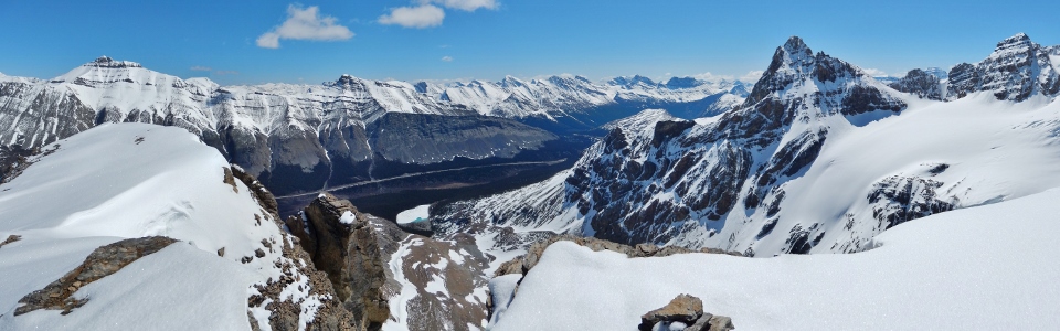
Icefields panorama. From left to right: Mount Athabasca, Mount Columbia (distant), Snow Dome, Mount Kitchener, Stutfield Peak and the Sir Winston Churchill Range. Click to see larger.
.jpg)
Impressive seracs on the Little A Glacier below.
.jpg)
One last summit selfie before heading back down the ankle twisting frozen scree slope.
.jpg)
Taking a load off at the base of the steep summit slopes. Rather than retracing my rocky ascent steps along the broad ridge, I donned the snowshoes and made haste down a large snowfield to the skier’s right.
.jpg)
My shoe track curls its way down below mighty Mount Athabasca. Once the snowfield gave way to open alpine meadows, I made my way back towards the snow coach parking lot, eventually rejoining my ascent route.
.jpg)
Tourists stimulating the economy on the Athabasca Glacier. On this day, everyone was treated to fine views at the Columbia Icefields (whether they climbed an 11,000er, bagged a wintry scramble or simply took the bus up)!
.jpg)
.jpg)
.jpg)
.jpg)