The Big Sister has been on my “to-do” list for years. I’ve driven by this peak hundreds of times and can even see it on my commute from work in Calgary. Despite its iconic status, I’ve always passed it up in favor of other objectives because I prefer to scramble around Canmore in shoulder season when the peaks are snow-covered and (in my opinion) more scenic. Of course, Kane strongly advises that the Big Sister not be attempted under snowy conditions as a result of a steep north-facing traverse just below the summit. By the time that the snow has melted on Big Sister, I generally find myself more inclined to tackle peaks further to the west in the main ranges.
That was to be the plan on this day as well; that is, until I let Brianne sleep in. Usually wives are happy when you let them sleep in (until 8:00am on a Sunday no less!) but mine is no usual wife! Upset that we wouldn’t be getting our customary alpine start, she insisted suggested that we set our sights on a peak in the front ranges so that we’d be done at a reasonable hour. As far as “Plan B”s go, I must say that the Big Sister proved to be an excellent one! In fact, as we enjoyed the interesting moderate scramble and watched poor weather engulf the main ranges to the west, I found myself thanking Brianne for her “suggestion!”
.jpg)
The famous view of the iconic Three Sisters from Canmore (image courtesy Wikipedia). From left to right (and in order of increasing height): Little Sister (Charity Peak), Middle Sister (Hope Peak) and Big Sister (Faith Peak).
.jpg)
Unlike the Little and Middle Sisters which are ascended from the Bow Valley near Canmore, the Big Sister is ascended from the Spray Lakes valley. As you can see, Big Sister looks quite different from the trailhead at TransAlta’s Three Sisters dam. From here, an obvious trail ascends the treed bump on the center left before descending into a gully running immediately below the left-hand skyline ridge. Eventually, this gully merges with the skyline ridge which is followed all the way to the summit.
.jpg)
Although well-defined, the trail up through the woods is STEEP. As we neared the tree-line, we were aware that we would soon have to descend a steep wall to the climber’s right. Although we were prepared to down climb the 5 m wall at the point that Kane suggests (just above a “cave-like hole”), we kept an eye out for cairns to our right, knowing that the Golden Scramblers, Josee and Fabrice, had found a much easier “groove” below the usual down climb. As it so happens, we found the sought-after (sometimes faint) cairned path to the right just above the slabs that Brianne is ascending in this photo.
.jpg)
The path quickly led to this fallen log which bisects a small rock band. We hiked down alongside the log, entering a broad gully.
.jpg)
Once in the broad gully, we were able to spot a characteristically shaped overhanging rock (above in this photo) which we knew to be close to the easy “groove.” We followed the gully upwards for 40 – 50 m, trending gradually to the right as cairns led us to the “groove.”
.jpg)
As advertised, the “groove” provided very easy access to the ascent route up another broad gully just below the skyline ridge.
.jpg)
Brianne makes her way up steep slabs with the skyline ridge visible behind her. Did I mention that this ascent was STEEP? While Brianne actually enjoyed this section, I wasn’t a fan of the loose pebbles covering the steep slab (picture marbles on a floor – except the floor is on a 35 degree slope).
.jpg)
Another party demonstrates that there are numerous places where you can complete the first down climb to reach the steep loose ascent gully.
.jpg)
STEEP, STEEP, STEEP, STEEP!
.jpg)
Eventually, the gully and the skyline ridge merge and the ascent angle relents (somewhat).
.jpg)
Following the slabby ridge – onwards and upwards.
.jpg)
Shortly after the ridge and gully routes merged, we encountered this 2 m climb. Although the holds were good, we both found the exposure below to be unnerving and felt that this was the crux of the day.
.jpg)
As we continued up the ridge, we eventually came face to face with the famous pinnacles which must be by-passed to the left just before the summit. In order to reach the by-pass, however, we would have to down climb 10 meters.
.jpg)
Brianne tackles the down climb. The climb looked somewhat intimidating at first but we actually found it easier than expected as the holds were excellent and there were many small perches that one could rest upon.
.jpg)
Almost there! By-passing the pinnacles on a good scree ledge to the climber’s left. This is the section that Kane suggests must be dry as a slip would result in a nasty (and very long) slide down the steep 50 degree terrain below.
.jpg)
A partial panorama of Spray Lake taken from between the two pinnacles just below the summit. Click to see larger.
.jpg)
“Spider Goat” tackles the last of the slab en-route to the 2936 m high summit of the Big Sister. Appropriately enough, the body of water 1200 m below her is Goat Pond.
.jpg)
One of the 16 Alpine helicopter tours which we counted during our ascent flies above Goat Pond but well below us.
.jpg)
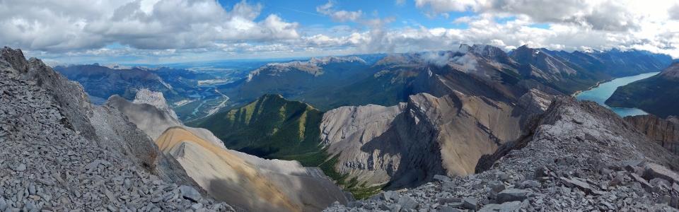
The summit offered up a spectacular view of the Bow (left) and Spray (right) Valleys in addition to the prairies beyond the front ranges. Click to see larger.
.jpg)
Looking beyond the Middle and Little Sisters (left) towards bright green Wind Ridge (right) and the blue Bow River below.
.jpg)
Looking southeast beyond Rimwall Summit to the larger peaks of the Kananaskis Range, including: Mount Lougheed (center) and Mount Sparrowhawk (right).
.jpg)
A closer look at Mount Lougheed I and II (center) and Mount Sparrowhawk (right). Rimwall Summit is the smaller peak in the foreground while reddish Mount Allan can be seen on the left and pyramidal Mount Bogart can be seen on the right.
.jpg)
Brianne enjoys some summit tea to compliment the lovely but chilly summit view.
.jpg)
The panorama to the northwest was no less impressive featuring fine views of the Goat Range (left), Mount Rundle (center) and the Fairholme Range (right). Goat Pond can also be seen on the left while Canmore can be seen far below on the right. Click to see larger.
.jpg)
Looking up the Goat Creek Valley towards the main ranges.
.jpg)
Unsettled weather over the main ranges. Pilot Mountain and Castle Mountain are discernible and the center left and center right, respectively. While our summit stay was sunny, we saw numerous squalls all around us. Fortunately, we did not find ourselves caught in one until we were back below the tree line on descent!
.jpg)
Banff landmarks visible beyond Mount Lawrence Grassi (foreground) – from left to right: Mount Norquay, Mount Brewster, Mount Rundle and Cascade Mountain.
.jpg)
You mean we have to get all the way down there before we get to have a beer?!
.jpg)
Panorama looking down the Big Sister (left), Middle Sister (center left) and Little Sister (center left). Click to see larger.
.jpg)
From the Big Sister, the path up the Middle Sister (foreground) looks like a highway. Grotto Mountain and Mount Fable are both obvious beyond the Three Sisters on the left.
.jpg)
The Bow River winds past Deadman’s Flats towards Lac des Arcs and Exshaw.
.jpg)
Rocky Skogan Peak (left) and grassy Mount Collembola highlight the view towards the east. A sunny Moose Mountain can also be seen on the distant horizon (center).
.jpg)
A stormy Spray Lake panorama. The lake is bookended by Mounts Sparrowhawk and Bogart on the left and Old Goat Mountain on the right. Click to see larger.
.jpg)
A squall partially obscures the British Military Group (the three most prominent peaks visible are Mount French, Mount Robertson and Mount Sir Douglas) beyond Mounts Engadine and Buller (left).
.jpg)
A quick "happy couple" summit shot amidst deteriorating weather before it was time to GTFD!
.jpg)
Retracing our steps along the base of the pinnacles.
.jpg)
Brianne makes her way back up the 10 meter down climb to regain the slabby skyline ridge.
.jpg)
Earning some serious style points on descent.
.jpg)
More style points: this is, apparently, called the “octopus walk.”
.jpg)
Ugh. Hundreds of vertical meters of loose rock over steep slab. We would make our way down below the rock band on the right until just beyond the treed plateau in the center of the photo. The nature of this terrain made our progress downwards painfully slow.
.jpg)
As the terrain became grassier, we arrived back at the point where one should climb back up onto the ridge. From where this photo was taken, you can see Kane’s route back up (just below the twin trees on the far right) and the route to our easy “groove” which is directly behind the big tree in the center.
.jpg)
Making our way back up the easy groove. Once through the groove, we were almost suckered into descending an obvious path down the gully on the other side before we realized that we still had to traverse beyond the fallen log to the skier’s right to regain our original ascent trail. Make sure that you take the time to carefully retrace your steps on this section lest you get suckered down into unfamiliar terrain! Our penance for not paying close enough attention was to re-ascend 30 meters until we found the log.
Once back on the trail, our progress was still slow thanks to the steep terrain but, at least, we were done with the scree on slab! After about an hour, we finally managed to make it down to that waiting beer in Canmore!
.jpg)
.jpg)
.jpg)
.jpg)
.jpg)