Baby Buller (North Ridge of Mount Buller Peak)
Elevation: 2506 m
Elevation Gain: 760 m
Baby Buller is the high point along the connecting ridge which extends northward from Mount Buller. Mount Buller was named for Lieutenant Colonel H. C. Buller, a member of the Princess Patricia’s Canadian Light Infantry who was killed during WWI. Some 300 m lower than the summit of Mount Buller, Baby Buller nevertheless offers pleasant views of the surrounding area. During winter months, the broad gully below the Mount Buller – Baby Buller col is a popular back-country skiing objective offering 700 vertical meters of descent on open but avalanche-prone slopes.
My Ascents:
April 27 2014
Trailhead: North Ridge of Buller Parking (Roadside)
One of the wonderful things about having your own mountain adventure website is that it can put you in touch with other like-minded mountain-obsessed individuals. Raf (aka: the Raffinator) is one such individual. For those of you who don’t know Raf, I’d highly recommend visiting his website; with 475 different summits (and counting) listed on his CV, the man is one of the more experienced peak baggers in the Canadian Rockies. After being in touch with Raf for a couple of months, Sunday finally afforded me the opportunity to meet and team up with him for an ascent.
With Mountain-Forecast.com predicting clear skies over the Wapta Icefield, I was keen to get out to the main ranges, however, Raf’s highly sophisticated weather predicting system (which inexplicably involves looking at the predicted wind speeds over 300 km south of the Wapta) suggested that the Wapta would be socked in (isn’t it always?). Rather than trusting the weather man (who has led me astray before), I decided to defer to Raf’s experience and we selected the North Ridge of Mount Buller in Kananaskis as our target for a snowshoe ascent.
According to Nugara’s Snowshoeing in the Canadian Rockies guide, you can’t reach the highest peak of the North Ridge of Mount Buller due to exposure and avalanche danger but the view from the high point in the book is supposed to be pleasant nonetheless (even if Vern didn’t think so). Fortunately, neither Raf nor I (nor Crux for that matter) actually paid attention to the guidebook description. As a result of this ignorance, we were able to find our own route which actually led to the highest (supposedly unreachable) peak on the North Ridge of Mount Buller; a peak which we decided to nick-name “Baby Buller” since it has a nicer ring to it than “North Ridge of Mount Buller Peak.”
.jpg)
After a few short minutes bushwhacking from the parking area, we came across this open avalanche slope. Our objective Baby Buller is the treed ridge on the left while larger Mount Buller dominates the view on the right. The weather was cold and overcast and the day’s avalanche bulletin called for a low risk of avalanches at all elevations. If the conditions had not been favorable (warmer temperatures and higher risk of avalanches), I would not recommend this ascent route as it clearly follows a slide path. In the further interest of playing it safe, we stayed as close as possible to the trees on the climber’s left of the gully to minimize the risk of overhead cornice failure from Mount Buller’s sheer north face.
If you find yourself in this gully, please note: you're not on the route up the North Ridge of Mount Buller described in Nugara's snowshoeing guide. That route ascends several hundred meters to the north (out of sight here).
.jpg)
Apparently Raf gives good scratches!
.jpg)
Raf takes a break to admire the view as the sun peeks out from behind the clouds for the first time. As we started up the slope, a solo back-country skier made his way down leaving only his fresh line behind.
.jpg)
The early morning sun provided nice views of the Big Sister (left) and Rimwall Summit (right) above Spray Lake.
.jpg)
As the terrain in the gully began to steepen and Raf noted some thin areas, we opted to take a more direct line (climber’s left) up Baby Buller to minimize our exposure to the more avalanche-prone slopes of the gully. As you can see, the terrain on Baby Buller is STEEP.
.jpg)
Crux and I both employ the “four wheel drive” technique to ascend the steep snow slope. By this point, the cold had completely drained my camera of all life (despite charging it the night prior). As a result, all photos from this point on are courtesy of Raf (thanks Raf!).
.jpg)
Did I mention that the terrain on Baby Buller is steep? We kept thinking that the ascent angle would relent in a minute but it really never did until the summit.
.jpg)
Crux and I top out on the ridge crest to overcast views of Spray Lake. From this point, the summit was only a few short minutes away.
.jpg)
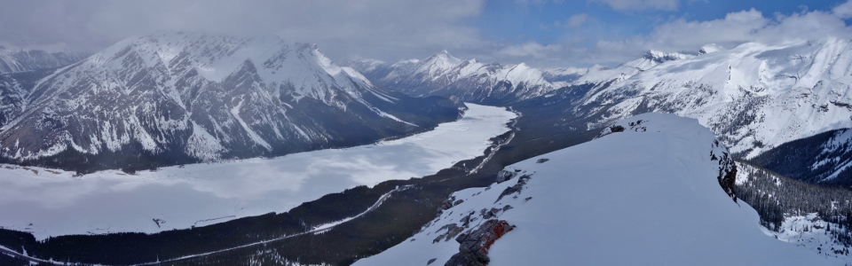
Panorama of Spray Lake curving around Mount Nestor and Old Goat Mountain from the top. Click to see larger.
.jpg)
Mount Turner, Cone Mountain, Mount Fortune and Fortulent Peaks (left to right) on the other side of Spray Lake and beyond the north face of Mount Buller.
.jpg)
Spray Lake stretches out to the north as Raf enjoys the view.
.jpg)
A brief clearing afforded us a summit view of some of the larger peaks near Canmore including the Big Sister (distant center) and Mount Lougheed (right). Click to see larger.
.jpg)
Crux was apparently “stoked” on the summit. He sure does look excited…
.jpg)
Crux and I on top!
.jpg)
Raf’s new best friend (or is it the other way around?).
.jpg)
A rare (on this day at least) glimpse of (from left to right): Mount Lougheed (I and II), Mount Sparrowhawk, Red Peak and Mount Bogart beyond the cornice to the east. Click to see larger.
.jpg)
Red Peak (also referred to as “North Buller Pass Peak”) immediately in front of Mount Bogart.
.jpg)
The open slopes of Mount Sparrowhawk to the north. Read’s Tower just visible on the left.
.jpg)
Mount Buller still towers over Raf from the summit of Baby Buller.
.jpg)
The striking corniced ridge connecting Baby Buller to Mount Buller.
.jpg)
Unnamed peaks beyond a large cornice on Mount Buller’s east ridge.
.jpg)
Crux loves long walks on corniced ridges and, for that reason, we decided to go for one. Actually, we decided that the descent from the Baby Buller – Buller col looked less steep than our ascent route and, although it presented a higher objective avalanche hazard, conditions were still quite favorable (read: COLD) so we opted to make our way to the col and plunge step down the open slopes following the back-country skier’s tracks.
.jpg)
Crux and I carefully follow Raf’s tracks along the ridge to the col avoiding the cornice on the right of the photo.
.jpg)
Descending a little below the ridge to ensure that we’re clear of the cornice. Despite the appearance (from afar) of more gentle terrain near the col, you can see that the slope here was still quite steep!
.jpg)
God it would have been nice to have skis here!
.jpg)
Mount Buller’s impressive north face from the col. Once we reached the col, we very descended quickly and did not stop until we had reached the more gently angled, treed terrain below. Conditions may have been favorable but neither of us felt like lingering on these steep open slopes.
.jpg)
Fortunately, the snow conditions were perfect for plunge-stepping down and, in no time flat, we found ourselves back on safer ground.
.jpg)
I think that Crux may have a new admirer based on the number of mountain dog photos that Raf took…
.jpg)
Crux and I making our way down as another group of skiers make their way up; they clearly didn’t get an alpine start as it was almost 2pm at this point.
.jpg)
As is so often the case in the Rockies, the weather improved as we descended affording us improved views of Cone Mountain (background), Mount Fortune (foreground) and Fortulent Peaks/Mount Turbulent (right).
.jpg)
Final views of Mount Nestor and Old Goat Mountain in the afternoon sun.
.jpg)
Looking back to the treed North Ridge of Mount Buller (left-hand foreground), Baby Buller (center foreground) and Mount Buller (obvious) from the highway en route back to Canmore for a pint at the Grizzly Paw. Thanks to Raf for a great outing – looking forward to many more!
.jpg)
.jpg)
.jpg)