Pigeon Mountain
Elevation: 2394 m
Elevation Gain: 990 m
Pigeon Mountain was originally named “Pic de Pigeons” in 1858 by the Palliser expedition’s botanist Eugene Bourgeau. Since pigeons had not yet been introduced to the area at this time, it is unclear why Bourgeau would choose this name. The peak’s east facing slopes are imposing, however, its west-facing aspect is significantly more gentle. Indeed, this west-facing slope was, briefly, the site of an attempt to establish a ski area in the Bow Valley. Unfortunately (or fortunately for those looking to get away from crowds), the warm Chinook winds that frequently howl through the area doomed this initiative from the start. Although the ski area has been closed since 1958, its scar is still visible while driving east on the Trans-Canada highway near Dead Man’s Flats.
My Ascents:
April 19 2013
Trailhead: Mount Lougheed Viewpoint
Having a job where you get every second Friday off is the best! When the “higher ups” first told me that this policy would be instituted effective April, my mind immediately raced to determine how many summits this new development might add to my annual tally! With a pitiful weather forecast for this weekend (actually for the third weekend in a row – where’s spring?), I was ecstatic to see sun and blue skies when I woke up at the crack of 10:30am on my Friday off (life is tough). Finally a chance to get out and (hopefully) bag a peak! Although I often stick to my usual roster of shoulder season scrambles at this time of the year, I distantly recalled after tallying up my summits at the close of the 2012 season, that I was 1 short of 100 different summits for my peak-bagging career. As a result, I was motivated to find a new shoulder season peak in order to claim my centennial summit. Pigeon Mountain, as it just so happened fit the bill perfectly. I reasoned that it would be a great choice since it was in a notoriously dry and windy area and, hence, would likely have little in the way of snow above the tree line. Turns out that I could not have been more wrong!
.jpg)
The objective, Pigeon Mountain, as seen from Dead Man’s Flats. With dry conditions, it’s little more than a steep hike that spurs off of the Skogan Pass trail (trailhead immediately north of the Banff Gate Mountain Resort), however, in snowy conditions (as I would soon find out), it turns out that this pigeon has teeth!
.jpg)
The Skogan Pass trail is more of a cut line actually. The road on the left parallels the cut line most of the way, however, with the exception of 2 ravines which cross the cut line, it’s best to stay off the road and in the sun on the cut line. There were signs at the base informing hikers that the Centennial Pass trail (which connects to Mount Allan) is closed at this time of year for bighorn sheep calving season, however, these signs made no mention of the Skogan Pass trail cutline. Even if they did, I’m not sure they would have stopped me (shhh…don’t tell the conservation officers).
.jpg)
A surprisingly scenic view (minus the power lines) looking back along the cut line to the Bow Valley.
.jpg)
After walking for just under an hour, the trail on the cut line suddenly fades and there is an obvious left turn with an Atco Gas stake (shown here). Turn left here for Pigeon Mountain. Presumably continuing straight on the road paralleling the cut line takes you to Skogan Pass, although I’m not certain.
.jpg)
After a couple of switchbacks on a wide trail, there’s another smaller trail which branches off to the left at this sign. If you’re planning to make your way up Pigeon Mountain, this is the way to do it!
.jpg)
One of my favorite hiking partners back for another year! This is Crux’s idea of breaking trail…
.jpg)
…and into the triple Lutz.
.jpg)
That landing is going to earn him some deductions from the judges.
.jpg)
Finally out of the trees! From this point on, the views of the Bow Valley were great. Also impressive was the massive herd of bighorn sheep heading up the hill to the right. I was only able to get about half of them in the camera frame here. I guess they calve here as well as the Centennial Ridge trail!
.jpg)
Roadblock. Crux was VERY interested in meeting these guys. Fortunately, he stays on leash while we’re hiking so he never got the chance!
.jpg)
Improving views of the Bow Valley with every step. From left to right: The Windtower, Rimwall Summit, the Three Sisters, Mount Lawrence Grassi and Ha Ling.
.jpg)
Looking back towards Mount Collembola, Mount Allan and Wind Mountain.
.jpg)
Crux!
.jpg)
The south summit of Pigeon Mountain comes into view above the snowy/grassy ascent slopes. Unfortunately, this is not the true summit.
.jpg)
The north summit is the true summit and it’s that little blip beyond the trees in the center left A LONG WAYS OFF.
.jpg)
The north summit looking tantalizingly close now. Unfortunately, this last stretch was by far the most physically taxing. Remember how I had reasoned that there wouldn’t be much snow up here earlier? Well, it turns out that there is. The trees on the left form a very effective natural snow fence which allows the snow to pile up waist deep. Beyond the trees, there were many sections where the snow was equally deep as a result of the angle of the terrain. There may not have been much vertical left at this point, but breaking trail through all of that deep, heavy snow was absolutely exhausting. I just couldn’t seem to catch my breath the whole way to the summit.
.jpg)
Despite the deep exhausting snow, Crux and I made it to the summit…only to be confronted with the perennial wind that batters this peak. The conditions may not have been ideal but it was fitting that I had to work suffer for my 100th summit!
.jpg)
The view of the prairies beyond Exshaw to the east. You can just make out Yamnuska peeking out from behind Door Jamb Mountain and Loder Peak with tiny Exshaw Mountain in front of them.
.jpg)
Mount McGillivray beyond the summit cornice.
.jpg)
Mount McGillivray, Skogan Peak and Mount Lorette in the shade while the Kananaskis Valley enjoys the sun.
.jpg)
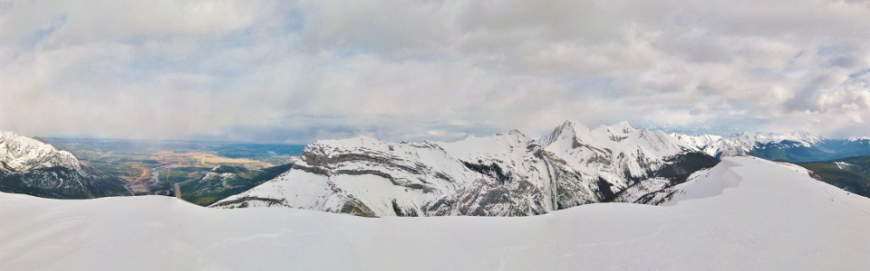
Panorama to the east. The weather forecast called for “unsettled” conditions, which is exactly what you can see here. Rain over the prairies and sun over K-Country. I saw a half dozen or so small rain storms over Canmore to the west as well. Luckily, none of them got Pigeon Mountain! Click to see larger.
.jpg)
Pigeon Mountain is perfectly situated to give an amazing view of the Bow Valley! From left to right: the Three Sisters, Mount Lawrence-Grassi, Ha Ling, EEOR and Mount Rundle.
.jpg)
The imposing north face of Mount Lougheed. Beyond Lougheed III on the left, you can just make out the summit bump of Mount Sparrowhawk.
.jpg)
Lougheed I and the smaller Windtower in front of Old Goat Mountain.
.jpg)
Mount Rundle high over Canmore. More “unsettled” weather to the west.
.jpg)
A surprisingly impressive panorama for a front-range peak! From left to right: The Wedge, Mount Collembola, Mount Allan, Wind Mountain, Lougheed III, Lougheed II, Lougheed I, Old Goat Mountain,the Windtower, Rimwall Summit, the Three Sisters, Mount Lawrence Grassi, Ha Ling, EEOR and Mount Rundle. Click to see larger.
.jpg)
Snowy Sisters.
.jpg)
Centennial summit shot! Thanks to the vicious wind, I only stayed up here for 4 minutes. A far cry from the ½ hour to hour that I usually spend enjoying the spoils of my efforts on a summit! Right after this photo was taken, it was time to run down the mountain to try to get back into Calgary in time for Brianne’s birthday BBQ dinner (the photo was taken at 4:30pm so I had to run fast!). Happy 100th summit but, more importantly, happy birthday Brianne!
.jpg)
.jpg)