Numa Mountain
Elevation: 2720 m
Elevation Gain: 1500 m
Numa is said to be the Cree word for both “thunder” and “lightning,” which, presumably, this peak sees its share of.
My Ascents:
July 19 2013
Trailhead: Floe Lake Trailhead
Elevation: 2720 m
Elevation Gain: 1500 m
Numa is said to be the Cree word for both “thunder” and “lightning,” which, presumably, this peak sees its share of.
My Ascents:
July 19 2013
Trailhead: Floe Lake Trailhead
Inspired by the beautiful photos in Vern Dewit’s recent Numa Mountain trip report, I decided to take advantage of a Friday off and pay a visit to this peak with the only scrambling partner I have who never says “no” – Crux! The fact that I’d been out until 11:30pm taking some Japanese visitors up Mount Fairview (before being wined and dined) the night prior did nothing to deter me. Nor did the advertised 1500 m elevation gain. Nor did the very hot and humid weather forecast. Nor did the fact that the avalanche gully that one climbs to gain Numa has been described as “foreshortened” and a “grind.” Nor did the fact that I forgot Crux’s lunch and, therefore, split my own with him. Nor did the fact that I promised Brianne that I would “try to be home for dinner”…Does anyone else see where this is leading?
.jpg)
The view of Numa Mountain from the Vermillion River which you cross 5 minutes after leaving the Floe Lake parking area.
.jpg)
Crossing the Vermillion River. This area was affected by the Vermillion burn: a forest fire started by lightning in 1968 which consumed 2950 hectares of forest in 4 days. As a result, there are no large trees and there are views for most of the 6 km approach hike along the Floe Lake trail.
.jpg)
The approach hike proved to be a wildflower photographer’s dream.
.jpg)
Crux enjoying his perch on the bridge crossing Floe Creek. The approach trail follows Floe Creek up the valley towards Floe Lake.
.jpg)
More colorful wildflowers.
.jpg)
Pink paint brushes.
.jpg)
Avalanches have cleared paths through the burnt timber, resulting in a very lush valley.
.jpg)
Stunning views of Floe Peak from lush avalanche gullies along the Floe Lake trail. While the trail is reasonably well-maintained, it is thin, very bushy and has an annoying habit of not gaining elevation (on the way up) and not losing it (on the way down). Indeed, less than 300 m (of the required 1500 m) was gained on the approach trail. The trail was very pretty on the way up but proved incredibly tedious on descent when I was dehydrated and exhausted.
.jpg)
Log jam on Floe Creek. Busy beavers?
.jpg)
A vast sea of fireweed colored the avalanche slopes purple.
.jpg)
Pretty asters.
.jpg)
After 6 km with only modest elevation gain, you come across this particular avalanche gully which is dryer than others before it and affords “fast” access to Numa Mountain (the long route involves hiking to Floe Lake- 12 km or so - and then to Numa Pass and then to the peak). The gully is badly foreshortened and the term “grind” does not begin to do it justice (particularly when heat and humidity are high). Numa Mountain is very pretty but this gully is a mother…I shared many choice words with it on the way up and have no intention of coming back any time soon!
.jpg)
Crux grinding his way up the gully. We started far below near Floe Creek. I think by this point, we were both panting with our tongues hanging out.
.jpg)
Mercifully, we found a waterfall in the center of the gully higher up, allowing Crux to have a cool drink!
.jpg)
Exhausted in the steep gully. I haven’t been this bagged on a peak in a long, long time.
.jpg)
The worst part about the avalanche gully is that once you get to (what appears from below to be) the top of it, you break through into a new steep avalanche gully. It felt as though it never ended (the vertical distance between where this photo was taken and where the creek is below can attest to that).
.jpg)
Higher up in the gully, you need to start trending climber’s left to avoid needlessly ascending an extra 100 vertical meters. Once you’ve trended far enough left, you should get your first glimpse of Numa Mountain’s upper scree slopes across a small col. The goal is to get to the col without gaining too much elevation and having to descend to it. I found that side-sloping near the tree line worked well in this regard, however, the side-sloping was somewhat unpleasant after the LONG grind up the gully (actually, gullies).
.jpg)
From the col, Mount Ball is spectacularly revealed to the east.
.jpg)
To the west, Floe Peak continues to dominate the view. The col is a beautiful spot to rest and enjoy the view.
.jpg)
When you are enjoying the view from the col, be sure not to look this way as the remaining 380 vertical meters of scree that separate you from the summit may prove de-motivational. The true summit is the high point visible on the climber’s right-hand-side.
.jpg)
At least there were some pretty flowers growing through the scree to distract you while you treadmill your way up.
.jpg)
With the benefit of four wheel drive, Crux made good time up the final scree slope…
.jpg)
…until, of course, he found a large snow patch to lie down and cool off in. At this point, you can finally start to see Floe Lake below Floe Peak.
.jpg)
Steep avalanche slopes into beautiful blue Floe Lake.
.jpg)
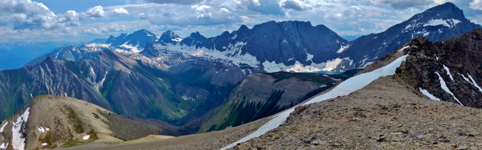
Finally on the short summit ridge! From here, the panorama really begins to unfold. On the left, Mount Verendyre can be seen beyond Floe Peak which towers above Floe Lake (center). Mount Foster lies beyond the western (false) summit of Numa Mountain on the right. The col that I just ascended from is visible in the lower left. Click to see larger.
.jpg)
To the north from the summit ridge, lies a large unnamed glaciated peak (left), Hewit Peak (center left) and the Rockwall. Unfortunately, after all the work involved in getting up here, the weather to the north looked less than ideal. With the heat and the humidity, I began to grow concerned about the possibility of an afternoon thunder storm.
.jpg)
The second highest peak in the southern Canadian Rockies (Mount Goodsir) pierces the stormy sky beyond the aptly named Rockwall.
.jpg)
Interesting lighting on the massive South Goodsir.
.jpg)
A new personal best for Crux! 1500 vertical meters! He looks thrilled, doesn’t he?
.jpg)
Summit panorama to the south where the skies looked a lot less threatening. Highway 93 to Radium and the Vermillion River (crossed earlier in the day) lie almost a vertical mile in the valley below. Click to see larger.
.jpg)
Zoomed-in panorama. The “Matterhorn of the Rockies” – Mount Assiniboine comes into view on the left while the White Tail Peaks, Mount Verendyre and an outlier of Floe Peak dominate the view on the right. Click to see larger.
.jpg)
A great view of Assiniboine.
.jpg)
The Vermillion River and Highway 93 far below.
.jpg)
The remains of a glacier at the base of Floe Peak.
.jpg)
A clear view of the Purcells through the Floe – Foster col.
.jpg)
Foster Peak (left) and more rapidly disappearing glaciers.
.jpg)
The panorama to the north features the Rockwall (left), the Ten Peaks (distant center), Vermillion Peak and Mount Hafner (center right), Stanley Peak, Mount Ball and Isabelle Peak (right). Click to see larger.
.jpg)
A very distant Mount Balfour and the Waputik Icefield can be seen between Mounts Biddle (left) and Hungabee (right). Neptuak Mountain and the pointy Deltaform can be seen on the right.
.jpg)
A stormy panorama of the Ten Peaks to the north. Mount Temple is the large broad peak flirting with the black clouds on the center-right. Click to see larger.
.jpg)
Mount Whymper is also visible to the north. This peak is an awesome scramble!
.jpg)
Proof that I suffered my way to the top.
.jpg)
Stanley, Beatrice, Ball and Isabelle panorama to the east. Click to see larger.
.jpg)
The southwest slopes of Stanley Peak offer scramblers a simpler option for reaching the summit of this lofty peak.
.jpg)
Glaciated Mount Ball.
.jpg)
Isabelle Peak across the highway.
.jpg)
“Can we go down before that storm gets here?” Probably a good idea…the nasty skies to the north prompted me to leave the summit after an uncharacteristically short 10 minute stay.
.jpg)
An hour later, I managed to retrace my steps back down the evil gully and am all smiles to arrive back at the Floe Lake trail 1200 m below the summit. The scramble down was steep and tiresome but it was, at the very least, quick. The smiles would quickly fade as I made my way back along the, by now, annoying Floe Lake trail for 6 km.
.jpg)
Crux enjoys a well-earned break on a cleverly constructed bench along the Floe Lake trail.
.jpg)
The 6 km hike back to the car proved to be painful. The high heat and humidity, combined with the sheer elevation gain undertaken, resulted in me becoming severely dehydrated (this despite drinking 3 L of water and a thermos full of herbal tea over the course of the trip). The de-proach trail seemed to never end and, worse still, several trees which had not been felled when I ascended earlier in the day had fallen while I was higher up. Helping Crux around messes like this added to my annoyance with this peak on descent. Worse still, the trail would SIMPLY NOT GO DOWN. It dilly-dallied about on hill-sides, sometimes gaining elevation, and rarely losing any. Again, some choice words were exchanged with the mountain. By the time, I arrived back at the car, I felt awful; a feeling which did not subside until I made it to the Castle junction gas station where a Coca Cola and a Powerade were consumed in short order. When I arrived home (much later than I had told Brianne I would), I had missed dinner by a significant margin and my popularity was not soaring. Numa is a beautiful mountain but I don’t think that I’ll be back…