Mount Ware
Elevation: 2124 m
Elevation Gain: 505 m
Mount Ware was named in 1951 after John Ware, a rare southern Alberta rancher of African-American descent. Ware is credited with bringing the first cattle to southern Alberta in 1882, an act which helped to create the province’s lucrative and well-renowned ranching industry.
My Ascents:
May 18 2013
Trailhead: Gorge Creek Day Use Area
After slacking off for several months this winter, it was finally time to get Brianne back out and onto the summit of a mountain. With a nasty-looking forecast for the long weekend, we decided to tackle a relatively small peak (although there’s nothing “small” about the approach): Mount Ware. Although the directions given in the popular “Where the Locals Hike” guidebook by the Copelands are a little convoluted, they can be summarized quite easily: hike for a little over an hour on the “South Gorge Creek” trail, passing through a cattle gate along the way. Shortly past a signed intersection in the trail, stay right and lookout for a cairn between two pine trees.”
.jpg)
A cool looking “waterslide” into Gorge Creek.
.jpg)
The instructions in the guidebook tell you to “rock hop” across shallow gorge creek a few minutes past the trailhead, however, there is no longer any need to – a bridge has since been built. This isn’t it, however. This was a cool looking snow bridge near the actual bridge.
.jpg)
Unnecessary rock-hopping. We got confused by the newly built bridge, not present in the guidebook, and rock-hopped across the wrong creek before quickly realizing our mistake and hopping right on back.
.jpg)
This is where we should have gone! Immediately over the bridge, take a left turn onto the South Gorge Creek trail. 1 minute past this sign, you turn right onto the south trail and continue on for a little under an hour.
.jpg)
Brianne working it.
.jpg)
Apparently we had some company on the trail on this particular morning…YO BEAR!
.jpg)
Although the approach is long-ish for such a small peak, there are some pleasant views of Gorge Creek along the way.
.jpg)
The pine trees and cairn that mark where you leave the main trail to ascend Mount Ware. The trail quickly peters out but as long as you keep going “uphill” you should come to a point where the trees start to thin enough to offer a view of your objective. From there, walk towards it! Luckily any bush-whacking necessary was easy in the thin lodgepole pine forest.
.jpg)
Spectacular views of Bluerock Mountain on ascent. There's even some blue sky up there!
.jpg)
The objective – Mount Ware finally comes into view through the thinning forest.
.jpg)
The upper grassy slopes are deceptively steep!
.jpg)
The stragglers making their way up.
.jpg)
Crux the dog on the summit of Mount Ware! More impressive Bluerock Mountain immediately to the west.
.jpg)
Bluerock Mountain, Mount Rose and Threepoint Mountain stretch to the north along the very front ranges of the Rockies.
.jpg)
Mount Rose and Threepoint Mountain under increasingly stormy skies.
.jpg)
Nasty looking weather over Outlaw Peak and Banded Peak beyond Mount Rose.
.jpg)
The Highwood Range stretches off to the south.
.jpg)
More stormy weather to the east over the flat lands. Despite the stormy weather all around us, we were quite lucky and actually enjoyed sun (and a tick!) on the summit for a little over 30 minutes before eventually heading back down.
.jpg)
Calgary to the north-east.
.jpg)
Our tick-magnet.
.jpg)
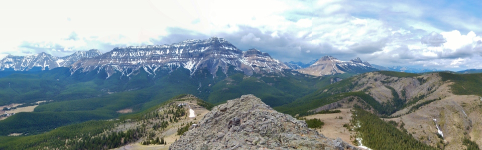
A pleasant front-range summit panorama. Click to see larger.
.jpg)
Group summit shot. It’s nice to enjoy a summit with the Boss again; the first of many this summer!
.jpg)
Spring is in the Rockies!
.jpg)
Cooling off in a Crux-sized snow patch on the way down – it was a little muggy out…
.jpg)