After spending all of last weekend in serious pain due to an ornery wisdom tooth, I called my dentist first thing on Monday morning to arrange an emergency extraction (side note: general anaesthesia is the best). 96 hours later, the hole in my jaw was still quite sore but I wasn’t going to let that keep me down, especially after not summiting anything the previous weekend as a result of the aforementioned wisdom tooth from hell. Growing weary of smaller summits, I was eager to take on my first “real mountain” of the season. With its location in the very front ranges, I reasoned that the west-facing ascent slopes of Mount Bryant would be snow-free. I also figured that the long and remote approach would keep the hordes of May long weekenders at bay. After pretending to be a rally car on the freshly opened Powderface trail dirt road, my favorite hiking partner and I started off on our Friday endeavor.
.jpg)
The view of Mount Bryant up Canyon Creek from near the “trailhead”. The approach is long as the route circles around the valley in front of the east face (visible in front of and to the right of the peak here) before going around the north and then west faces of the mountain. Essentially, you walk around the whole damned mountain before you start to climb it!
.jpg)
Canyon Creek is amazingly wide and flat. You could probably safely land a jumbo jet here if you had to.
.jpg)
The obvious “tributary” (made more obvious by the Alberta Parks sign at its entrance) that allows you to leave Canyon Creek behind (after about 20 minutes) and start on your long circle about the base of Mount Bryant.
.jpg)
Crux picking his way up the stream bed as it begins to narrow. The stream bed narrows and widens, is occasionally wet and occasionally dry, sometimes has a good path and sometimes has none. All in all, it still makes for a pretty dull approach (ESPECIALLY on the return trip).
.jpg)
Circling around the north face of the objective now (left). The route goes up the valley in the center of the photo back to the south (left) beyond the thickly forested slope on the left.
.jpg)
A cairn and a gurgling stream mark the point at which you should leave the main creek bed to head back south (left). Normally, there is a trail through the trees here.
.jpg)
Unfortunately, at this time of year, the steep treed slope is north-facing and any trail that might normally be present is lost in waist-deep snow! As a result, I had to ad-lib my way from here…
.jpg)
Part of the ad-lib: bush-whacking my way through pussy willow hell.
.jpg)
After a tremendous bush-whack through pussy-willows, pines and waist deep snow, I finally emerged from the forest into the alpine and found myself back on route! From here, you hike to a beautiful tarn hidden at the base of the steep rocky cirque.
.jpg)
The more gentle west-facing scree slopes shown just to the right of the snow here allow reasonably easy access to the summit of Mount Bryant – if you consider 500 vertical meters of scree to be “reasonably easy”!
.jpg)
Crux scouting out the route.
.jpg)
Flailing about in the snow. I’ve no clue why, but he insists on doing this every time we encounter snow.
.jpg)
Arrival at this pretty little (and in this particular instance – icy) tarn signal the start of the actual ascent.
.jpg)
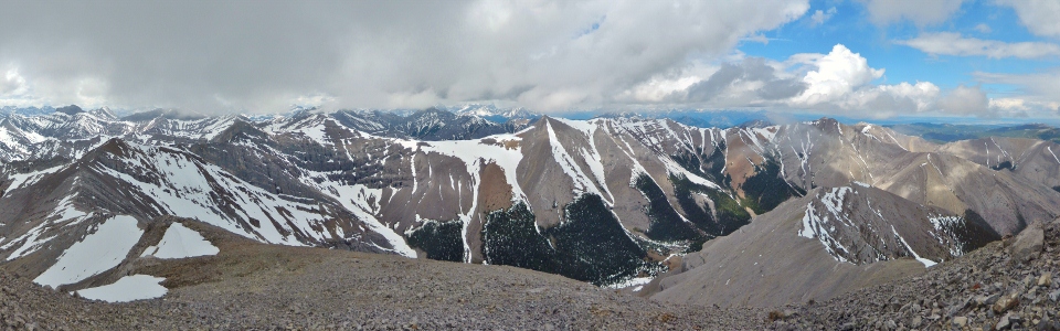
Panorama of the steep snow slopes surrounding the brightly colored tarn, sometimes referred to as Bryant Lake. Click to see larger.
.jpg)
Recent avalanches all about the tarn. Fortunately, the west-facing ascent slopes were bone dry.
.jpg)
Case in point: bone dry. The rock band visible here provides the only minor obstacle between the tarn and the summit. I found it easy to navigate near the buttress on the left.
.jpg)
A small rock window through the aforementioned buttress.
.jpg)
The rock band near the buttress can be overcome easily with a little hands-on scrambling…that is, if you have hands. Getting Crux up and down here proved to be a little more challenging.
.jpg)
Past the rock band (and most of the steep scree) now, Crux is on summit approach under an increasingly grey sky.
.jpg)
A cloudy view from the summit of my first “real mountain” of the season! Click to see larger clouds.
.jpg)
Cloudy views down to the approach valley to the north.
.jpg)
Compression Ridge immediately south of Mount Bryant and across Canyon Creek.
.jpg)
Group summit shot.
.jpg)
The impressive north face of the Fortress suddenly appears through a break in the clouds to the west.
.jpg)
Similarly, I’m afforded a brief glimpse of Mount Bogart.
.jpg)
According to the register, I was the first one up here this year!
.jpg)
Crux taking it easy and trying to stay warm.
.jpg)
Luckily for me, the clouds began to clear rather abruptly affording me an improved summit panorama of Kananaskis to the west (left) and prairies to the east (right). Click to see larger.
.jpg)
Looking west towards an overcast Mount McDougall.
.jpg)
The Kananaskis Range (from left to right: Mount James-Walker, Mount Chester (distant), the Fortress, Gusty Peak, massive Mount Galatea and the Tower) makes an appearance to the west.
.jpg)
Mounts Bogart (left) and Sparrowhawk beyond Mount McDougall.
.jpg)
The four peaks of Mount Lougheed towering over the Bow Valley to the north-west.
.jpg)
Mount Rundle and Cascade Mountain.
.jpg)
There were blue skies over some peaks on this day. Mount Bryant just wasn’t one of them.
.jpg)
Self summit shot.
.jpg)
Clearing skies to the north. Diminutive Midnight Peak beyond a northern outlier of Mount Bryant.
.jpg)
A distant and shady Yamnuska beyond Midnight Peak and Mount Baldy. Black Rock Mountain is the farthest peak to the east (right) in the distance.
.jpg)
Looking down the alternate east-ridge descent route towards Powderface Trail and a distant Moose Mountain. Given my four-legged companion, I opted to descend the same way that we came up.
.jpg)
Where Powderface Trail meets Canyon Creek and where my car is parked. A LONG way off. Time to start heading down I suppose.
.jpg)
Crux encountering some minor trail-breaking issues on descent. We made reasonably decent time back to the car, however, our progress home was slowed by the cop who pulled me over for going 119 km/hour while passing a trailer full of muddy quads and dirt bikes. Luckily he decided to let me go with a warning (because he was late for coffee with his friends).
.jpg)
.jpg)
.jpg)