Elevation: 6461 m
Elevation Gain: 3621 m
Mera Peak rises 31 km to the south of Mount Everest in the Himalayas. The Mera massif dominates the watershed between the Hinku and Hongu Valleys and has 3 main summits (south: 6065 m, central: 6461 m and north: 6476 m). Mera’s central summit was first ascended by Col. Jimmy Roberts and Sen Tenzing (members of the British Everest Expedition) on May 20, 1953. At this time, the mountaineering ascent was alpine grade F (facile/easy). More recently, a crevasse opened up across the northeast face historically used to climb the central summit block forcing parties to climb steeper more exposed routes to reach the top (alpine grade PD –peu difficile/not very hard). The first ascent of Mera’s slightly higher north summit was claimed by French climbers Marcel Jolly, G. Baus and L. Honills in 1975. Mera Peak is classified as a “trekking peak” by the Nepal Mountaineering Association (NMA), however, this term is somewhat misleading. According to the NMA, a “trekking peak” is any peak under 7000 m that is considered climbable by anyone with a moderate amount of mountaineering experience and skills. The ascent of Mera Peak should, therefore, be considered mountaineering and not simply a trek. While the Hinku Valley commonly used to approach Mera Peak was uninhabited and remote until recently, today the valley has become much busier as a result of commercial operators offering tours of Mera Peak. The valley, nevertheless, remains much less busy and much less developed than the neighboring Khumbu Valley which leads to Mount Everest. The vast majority of those who climb Mera Peak aim for the central summit; the slightly higher north summit is rarely visited. Regardless of which summit is attained, the view from the top of Mera Peak is outstanding, featuring 5 of the 6 highest mountains in the world (Mount Everest, 8848 m; Kangchenjunga, 8586 m; Lhotse, 8516 m; Makalu, 8475 m and Cho Oyu, 8201 m).
Our Ascent:
October 11 2013.
After spending another cold night at a tea house in Khare (5000 m), Brianne and I awoke to crystal clear blue skies. After days of trekking amongst view-depriving overcast skies and driving rain, we finally had good weather when we needed it most! Days earlier, our chances of summitting had appeared bleak; indeed, upon our arrival in Khare, we were greeted with the news that Mera had turned back all of those who had attempted her this season. Now, with good weather and yesterday’s news of the season's first successful summit bid, we hurried to reorganize our packs, leaving all unnecessary weight behind in Khare and soon were on our way towards what we hoped would, literally and figuratively, be the high point of our honeymoon: the central summit of Mera Peak (6461 m).
Brianne enjoys perfect views of Mera Peak (left) and Kusum Kanguru (right) under clear blue skies as Khare (bottom right) begins to disappear below us.
Along with sunny skies come avalanches like this one on Mera’s sheer north face.
Our wonderful porter Lakba carrying a very heavy load (including our rented mountaineering boots strapped on for good measure) towards high camp for us. Brianne and I are both immensely grateful to him for all of his hard work!
As we approach the Mera Glacier, a spectacular panorama of peaks towering above the Hinku Valley unfolds behind us. From left to right: Mera Peak (6476 m), Kusum Kanguru (6367 m) and Kyashar (6769 m). Click to see larger.
Lakba enjoys a well-earned break at the toe of the Mera Glacier.
The massive Mera Glacier stretches out before us. From here, our route gains the glacier using the rocky ice slope on the far left before crossing the relatively flat lower section of the glacier towards Mera La basecamp (center right) and finally starting the long icy journey to the summit (far right). Click to see larger.
A wall of ice, laden with boulders, to overcome at the glacier's toe.
Brianne gaining to the glacier. From here on, the rest of our trek will be an icy, crevassed one!
Brianne and our Sherpa Sarki take a break along the well-travelled trail that weaves its way towards Mera La. With fresh snow covering everything (remember all that rain that fell on us lower down?), small holes and ridges in the glacier’s surface are the only hint of the massive crevasses and fissures all around.
Mera La (left) below Naulekh (6363 m). Groups making their way to and from high camp on the glacier grant a sense of scale to the massive sea of ice.
It’s definitely best to stay on the broken trail en route to Mera La; in fact, it may have been best to rope up as well, however, we did not see a single group using a rope to get to Mera La.
A fork in the trail at Mera La (5415 m); one group makes their way towards base camp (left) while others press on towards high camp (the two rock outcrops next to each other on the left) and, ultimately, the nub-like central summit of Mera Peak (center). The true summit is just right of the central one and, from here, the two look approximately equal. While the route up the glacier towards the summit looks relatively flat from here, it seems much less so from high camp on! When our Sherpa suggested spending 2 days in Khare and climbing directly to high camp from there instead of 1 day in Khare followed by 1 day at basecamp, I was concerned; Neither Brianne nor I had ever been at altitudes remotely close to this and I was unsure about our ability to combine 2 days’ worth of ascent into 1. As we reached base camp and continued climbing, however, we both felt strong. In fact, we found the ascent from Khare to high camp remarkably easy!
Looking over towards the neighboring Hongu Valley for the first time from Mera La.
Above the La, 6 brightly colored tents mark the location of Mera basecamp as massive Chamlang (7321 m) comes into view. One great advantage to our decision to skip basecamp was the fact that it saved us 1 night’s sleep in a cold tent at altitude!
As we gained elevation, we were finally able to see our first 8,000er of the trek: massive Makalu (8475 m, center left) beyond Chamlang and the beautiful glacial lakes at its base.
With every step, the panorama becomes more and more spectacular as the afternoon sun gives rise to fascinating cirrus clouds above the monstrous Himalayan peaks. From left to right: Malangphulang (6573 m), Peak 41 (6574 m), Makalu (8475 m) and Chamlang (7321 m). Click to see larger.
More distant giants begin to come into view as Lakba makes his way onward up the Mera Glacier. Kangtega (6779 m) to the right of Kyashar; Ama Dablam (6856 m) to the right of Malangphulang and Nuptse (7879 m) on the far right. The rocky Hinku and Khare Glaciers merge in the valley far below.
The massive, heavily crevassed Sabai Icefall on the flank of Kyashar. This is the glacier that pours down into Lake Sabo Tsho which we visited several days earlier.
High camp within reach!
The summit of Mera Peak from near high camp. The route to the summit passes atop the large steep roll on the left and then up gentler slopes to the final steep summit block in the center.
Mera’s high camp is breath-taking due to the high altitude, the scenery and its precarious position perched on a small rock outcrop high above the Naulekh Glacier.
The Mera Glacier plunges over a cliff in an impressive icefall from high camp.
Mera high camp is a ragtag collection of tents pitched wherever it is possible to do so upon the small rock outcrop. Options for exploring around high camp are, essentially, nil and the bathroom is wherever the fewest people are looking when you have to go.
Looking down on our little blue and yellow tent from above on the rock outcrop, it becomes obvious just how precarious our perch here is. Unfortunately for us, our tent (which was provided for us in Khare) lacked certain amenities such as a ground tarp to keep us dry when we were in it and a door with a functioning zipper. These “luxuries” would have been greatly appreciated but, fortunately, did not prove entirely necessary (ie: we lived). Note also the black tent next to ours which was a kitchen tent for a large group of Hungarians who would be attempting the summit the next day alongside us. If the melting snow from beneath and gusting wind from the broken door weren’t enough to ensure a poor sleep, the Nepalese cooks and porters in the kitchen tent stayed up late until after 9:00pm banging pots, yelling and laughing. This may seem reasonable until you consider that bedtime at high camp is 6:00pm since everyone intent on trying for the summit the next day must be awake by 2:00am!
A first class meal of soup made from melted snow for dinner! As always, thanks to our chef, guide and climbing Sherpa Sarki!
Day 10: Mera Peak (6461 m)
2:45am: Rise and shine (your headlamp that is)! After an abysmal night’s sleep (I estimate 15-30 minutes at most), it was time to get geared up (not a huge problem since we slept with most of it on), roped up and ready to go! What ensued was a grueling march through the dark but surprisingly warm (-10°C) night watching as a long line of little lights made their way up the dark glacier. Although we both found the climb to high camp relatively easy the day prior, I struggled mightily as we made our way up through the featureless night. No matter how often, or long, that we rested, I simply could not catch my breath and I felt constantly exhausted. Brianne, however, seemed to be doing fine. She was roped up in front of me and I recall always feeling dejected when our breaks would come to an end and I would watch helplessly as the rope between us became taut and the climb resumed once more. Despite how poorly I felt, we seemed to make good progress and passed all groups in front of us save one before all was said and done.
5:45 am: We pause at first light and turn our attention to the east waiting for the sun to rise over the Himalayas.
One of the most beautiful sights on earth: the sun rises above the third highest mountain in the world (Kangchenjunga, 8586 m) bathing us in warmth following a cold night of climbing.
The dawn’s first light reaches the top of the world as Mount Everest (8848 m) and Lhotse (8516 m) are bathed in alpenglow. To the left, Nuptse (7879 m), Malangphulang (6573 m) and Pumori (7145 m) remain in the Everest massif’s lofty shadow.
Above 6000 m, the elements were harsh and the sun strong (even in the early morning). As the day drew on, the sun’s intensity began to sap what little strength I had left.
Mera Peak’s summit block finally in sight! Fixed ropes and a jumar are required in order to complete the final 10 m ice climb to the summit. Often, there is a large crevasse present where the person in this photo is standing, however, this year it was filled by the massive recent snowfalls making the final ascent a little less daunting. Nevertheless, by the time that we reached the high plateau below the summit, I was absolutely exhausted and wasn’t certain that I had the strength left for the final climb.
The panorama from the high plateau below the summit block was outstanding and I enjoyed a long rest here, taking photos and stuffing digestive cookies down my mouth, while our Sherpa Sarki fixed ropes up to the summit. Click to see larger.
Smiling for a photo but, really, I’m deeply concerned that I don’t have enough gas left in the tank to make the final summit push.
Brianne goes for it! With the fixed lines ready to go, rest time was over. When she started up the rope, she wasn’t sure if she’d see me on the summit or not. Afterwards, she told me that she’d never seen me so exhausted.
On top! Fortunately, my many years of peak bagging in the Rockies had taught me that getting to the summit (no matter how high) is often simply a matter of putting your nose down and placing one foot in front of the other and, indeed, this was the case here. The final climb actually wasn’t as difficult as I thought it would be, however, I must note that I later saw video evidence (see below) which suggested that I didn’t exactly make my way up the rope quickly!
7:15am: Greeted by long shadows and a spectacular view of the green Hinku Valley below Mera’s west (6255 m) and north (6476 m) peaks. Click to see larger.
My beautiful wife on top of the world (or damned close) and, for once, happy to see me!
The most amazing honeymoon destination that anyone could ask for.
Another group approaches the summit in the, now hot, morning sun. To the right, Naulekh (6363 m) is now below us while Kangchenjunga (8586 m) rises above all else on the horizon to the left.
From the summit, a large cornice actually obscured the panorama towards Mount Everest somewhat. Click to see larger.
Telephoto of Everest’s summit (8848 m) rising up from behind the fourth highest mountain in the world Lhotse (8516 m).
The view towards the world’s fifth highest mountain Makalu. From left to right: Kangchungtse (7678 m), Makalu (8475 m), Chamlang (7321 m), Peak 5 (6388 m)and Peak 6/Tutse (6758 m).
Another team gains the summit block nearly 3 vertical km above the green valley below. The last of the glaciated giants Mojang Peak (5896 m) and Sanu Peak (5996 m) give way to smaller ranges to the south. The space on top of the summit was at a bit of a premium and this signaled the beginning of the end for our summit stay.
Our SPOT GPS was intermittently useful on the trek; fortunately it did work on the summit (putting our moms’ minds at ease back home in Canada)!
One last photo of the honeymooners with Makalu before descending.
Brianne rappels off the steep icy summit block.
Enjoying the view now that we’re below the summit cornice and have a little more room to maneuver than we had up top.
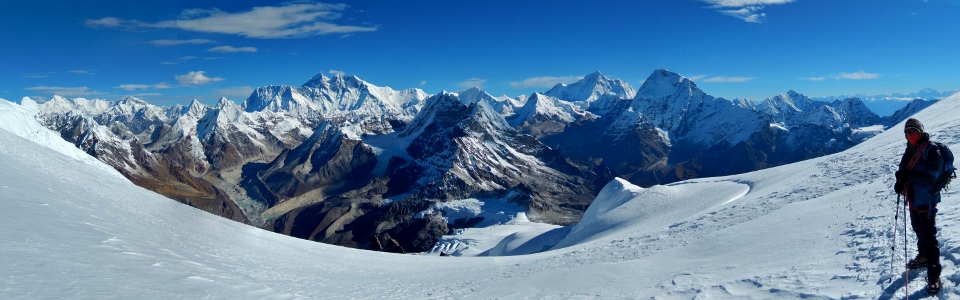
An absolutely astounding view of the peaks in the Solukhumbu region. Mouseover for peak names and elevations.
A closer view of Everest, Lhotse, Lhotse Shar, Peak 38 (strange that such a small outlier would be named while other larger ones are not) and Shartse.
The sixth highest mountain: Cho Oyu (8201 m) some 50 km away.
Lakba soaking in a final panorama including 5 of the 6 highest mountains in the world (#1 Everest, #3 Kangchenjunga, #4 Lhotse, #5 Makalu and #6 Cho Oyu) before making our way down the long flowing mass that is the Mera Glacier. Mouseover for peak names and elevations. Click to see larger.
A closer look at Kangchenjunga and its massive range 125 km away. Mouseover for peak names and elevations.
Mera La from high above. If one squints, one can make out a small group of tents (basecamp) on the rocks just to the right of the La. Not wanting to relive last night’s insomnia, our goal was to make it all the way down to Khare, well below high camp and even basecamp, so that we could spend the night in a tea house instead of our pitiful little tent.
This Japanese gentleman definitely had the right idea! Words cannot describe how jealous we were watching him cruise by on descent while we painstakingly retraced our steps down the glacier. Of course, we were significantly less envious when we had watched him carry his skis up the mountain on his back earlier in the day…
Finally back at high camp after an exhausting morning. At this lower elevation, more proximate peaks like Peak 41 (6623 m, center) begin to obscure the much larger 8,000ers beyond. Click to see larger.
Looking a little red but still managing a smile despite the fact that I became relatively ill on descent. Indeed, as we left the summit, I began to feel very “out of it.” Fortunately, I was still coherent, had no problems breathing and was strong enough to keep a good pace. When we reached high camp, however, I realized that I was burning up and stripped to my underwear in our tent, holding a bottle of ice (used to be water) against my forehead for an hour in the shade while Brianne packed up around me. After resting for an hour, I felt strong enough to get dressed once again and continue down towards Khare. Unsure of the cause of my malaise, I was eager to get back down to lower elevations (5000 m)! With the benefit of hindsight, Brianne and I suspect that I was suffering from a severe case of sun stroke coupled with exhaustion, dehydration and the early stages of a stomach virus which hit in full force later that evening.
Kyashar and Kangtega tower high above our destination for the evening, Khare (barely visible, perched at the base of a moraine near the center of this photo).
Telephoto of Khare in the valley below – still a long way down!
Down at Mera La, Sarki and Brianne look back up towards the summit one last time. An hour and half later, we stumbled (literally) into Khare around 1:30pm and exhaustion began to set in. Despite weeks of promising ourselves beer and potato chips when we got down from the summit, I simply didn’t feel well enough to do so. Instead, I spent the rest of the day in the shade attempting to shake a persistent chill.
As hinted at earlier, when we returned home to Canada, we stumbled across this video on YouTube. The video, posted by German friends who we had the pleasure of meeting during our trek, wonderfully chronicles their ascent of Mera Peak alongside us. Moreover, they actually managed to capture Brianne and I jumarring up the final summit block! Keep an eye out for us around the 1:10 mark of the video as Brianne (wearing blue) reaches the summit and I (wearing black with a stylish green backpack) slowly embark on the final climb. Thanks to Sigi and Kati for catching this amazing moment on film! For the best viewing experience, be sure to watch in HD fullscreen.
Day 11: Kothe (3691 m)
Final views towards the summit of Mera Peak as we make our way back from Khare towards Tangnag, retracing our steps from earlier in the trek.
Without the need to acclimatize, we stepped up our pace, by-passing Tangnag and making our way straight to Kothe from Khare following the scenic Hinku River.
A sunnier day at the monastery than earlier in our trek.
Below 4000 m, the trees began to return and the landscape grew greener and greener.
Back down to Kothe and our favorite little tea house. Here, we finally treated ourselves to beer, a hot shower and potato chips! We even did some laundry since the sun was out. Of course, as soon as we went to dry our clothes by laying them out on the lawn, the sun disappeared. We would not see it again.
While enjoying our beers, we were mesmerized by the amazing waterfalls across the valley. After treating ourselves, we settled in for a warm and pleasant night around the wood stove of the friendly Lama Lodge.
Day 12: Zawtra (4300 m)
One of the painful aspects of this trek was getting down below Kothe (3691 m) and then having to make our way 1100 vertical meters BACK UP Zawtra La on the way back. As you can see, we once again had splendid weather for this leg of the trek. We arrived in Zawtra (4300 m) soaking wet and exhausted. We were worried that all of the rain at lower elevations might be falling as snow at Zawtra La (4610 m), making this steep section potentially very dangerous. Unfortunately, once we arrived at Zawtra, we were far too tired to press on over the pass. Instead, we spent the night in Zawtra and hoped for a break in the precipitation. The rain fell harder and harder on through the night.
The great potato chip debacle of 2013. Brianne desperately wanted Pringles again once we arrived in Zawtra so we ordered and paid for “chips” (as those in North America would refer to Pringles). We were both perplexed when the tea house owner took our money and left without handing over the Pringles clearly on display! I went to find him to try to ask for the chips and when I did, this just seemed to confuse matters more. Ultimately, through charades, I was able to procure the Pringles for Brianne. Moments later, the “chips” (or fries as we North Americans would call them) arrived from the kitchen. Oops! Luckily Brianne had no objection to eating all of the fried potato products that had been presented to her!
Day 13: Zawtra La (4610 m) and Lukla (2840 m).
The day dawned much as yesterday had ended: bleak and wet. The driving rain had continued through the night raising the ground water level to the point where it looked like the outhouses would overflow shortly. A quick glance up towards Zawtra La confirmed our fears that the pass would be snowy and, potentially, dangerous. At this point, we still had no idea just how snowy and dangerous our journey over Zawtra La would end up being.
Zawtra La (4610 m) plastered in heavy, wet snow. Photo by Sigerl Steirer.
After reaching Zawtra La, we were forced to traverse steep hillsides in knee-deep fresh, heavy, wet snow. Several groups that had left Zawtra around the same time in the morning quickly combined into one large mega-group as it became more and more difficult to break trail. The mega-group moved painfully slowly below steep cliffs, over which snow was sloughing – the early signs of impending avalanches. Thanks, in large part, to the trail-breaking efforts of the Sherpas, we arrived at the lower pass (4500 m) shown here after 1 hour of difficult and dangerous travel. Photo by Sigerl Steirer.
Unfortunately, once we crossed the last pass, the most dangerous part of our day was still ahead of us as we had to traverse and descend the steep slopes on the other side. As we made our way along, we crossed the paths of 3 fresh avalanches. At one point, we even heard the terrifying tell-tale rumble of an avalanche. The entire mega-group stopped and listened anxiously; with zero visibility, we had no idea where the slide was. Fortunately, we were not in its path. Some of those in the group grasped the seriousness of our situation and wanted to move as quickly as possible. Unfortunately, others did not; one man even asked for a “break” while most of the group was in a gully filled with fresh avalanche debris. In the deep, heavy snow and steep terrain, single file was the only way to pass. This photo was taken, looking back at the pass and the steepest slopes above it following the tense traverse. Once again, the photo is courtesy of Sigerl Steirer as I was not willing to stop to find my camera while in avalanche terrain! Fortunately, all’s well that ends well and the entire mega-group emerged from the snow and descended safely into the pouring rain below 4000 m. The rest of the long walk back to Lukla was muddy and wet but, thankfully, uneventful. When we arrived there, our cold room was moldy and the toilets wouldn’t flush. In an effort to cope with the cumulative trauma of the day, we overindulged in Everest beer and got hammered for the first time in weeks.
Days 14 and 15: Lukla (2840 m)
With our flight back to Kathmandu not scheduled until the next day, we found ourselves mildly hungover with a day to kill in Lukla. This was mostly spent wandering “the street” (there’s really only 1). At the far end of the street is the gateway to Mount Everest and the start of the more popular Everest Base Camp trek.
With little else to do, we amused ourselves by making up yak-related puns. All he ever does is yak yak yak.
Candid shots of daily life in Lukla.
Prayer wheel or merry-go-round? In this temple, it would appear to be both.
Hair of the dog at the Hard Rock Café. Note the stylish new hat! Turns out that finding “Mera Peak” toques in Lukla was difficult enough, let alone trying to find ones that listed the correct elevation of the summit that we climbed! Fortunately, we had nothing better to do and were able to devote the better part of an afternoon to the cause.
After spending one last night in the hell hole Khumbu Resort lodge praying for good weather so that we could fly out of Lukla, we awoke to clear skies and a beautiful view of Nupla (5878 m).
The Lukla airstrip with Lukla and Nupla in the morning sun.
Time to take our chances taking off from the world’s most dangerous airport; note the 12 degree incline on the runway!
...and we're off!
Brianne was nice enough to give me the window seat on our flight back to Kathmandu – partially so that I could see more mountains and partially so that I wouldn’t have a heart attack every time we hit a little bump in our rickety plane! Namaskaar Himalayas!
Epilogue: Kathmandu
Back to “civilization”! During the rain-soaked, bland dal bhat curry-filled days early on in our trek, a fellow trekker who shall remain nameless (Marten!) filled our heads with visions of the delicious and savory “chicken sizzler” available in Kathmandu. To do so when nothing but rice and potatoes was available for weeks was nothing short of cruel! ;-) As you can see, chicken sizzler and beer was high on the priority list once we arrived back in Kathmandu!
Enjoying the sights, sounds (CAR HORNS) and smells (we won’t go there) of Kathmandu: Swayambhunath (more commonly referred to as the Monkey Temple by visitors). The monkeys may look cute but be warned: they bite! Luckily, we didn’t find this out first-hand but the French tourist in front of us was not so fortunate…
Despite concerns of rabid monkey bites, the view of Kathmandu in the valley below was outstanding from the top of the temple.
The centerpiece of the temple: the stupa at the top.
Rabid monkey patrol.
This one is clearly too cute to be rabid!
That evening, we were treated to a wonderful traditional Nepali meal at Bhojan Griha by our host Pamfa from Langtang Ri Trekking and Expedition. Over dinner, we learned that this restaurant had once been the home to the royal priest of the Nepali King. We also learned that tikkas are no match for my perspiration whilst consuming curry.
Dinner at Bhojan Griha was superb! In addition to immersing ourselves in the country’s traditional cuisine, we were also treated to wonderful displays of Nepali culture including these traditional dancers.
Kathmandu nightcap: enjoying roof-top Everest beers in Thamel after dinner. A perfect end to the Himalayan portion of our honeymoon. After 3 weeks in the cold, it was now time to finish off our honeymoon in style (and more importantly in 40°C heat) with 2 weeks in sunny Thailand! For the most amazing honeymoon imaginable, thank you to: all of the friends that we met while trekking, Langtang Ri Trekking and Expedition (especially Pamfa), Lakba, Sarki and, most importantly, my wonderful wife!
.jpg)
.jpg)
.jpg)
.jpg)
.jpg)
.jpg)
.jpg)
.jpg)
.jpg)
.jpg)
.jpg)
.jpg)
.jpg)
.jpg)
.jpg)
.jpg)
.jpg)
.jpg)
.jpg)
.jpg)
.jpg)
.jpg)
.jpg)
.jpg)
.jpg)
.jpg)
.jpg)
.jpg)
.jpg)
.jpg)
.jpg)
.jpg)
.jpg)
.jpg)
.jpg)
.jpg)
.jpg)
.jpg)
.jpg)
.jpg)
.jpg)
.jpg)
.jpg)
.jpg)
.jpg)
.jpg)
.jpg)
.jpg)
.jpg)
.jpg)
.jpg)
.jpg)
.jpg)
.jpg)
.jpg)
.jpg)
.jpg)
.jpg)
.jpg)
.jpg)
.jpg)
.jpg)
.jpg)
.jpg)
.jpg)
.jpg)
.jpg)
.jpg)
.jpg)
.jpg)
.jpg)
.jpg)
.jpg)
.jpg)
.jpg)
.jpg)
.jpg)
.jpg)
.jpg)
.jpg)
.jpg)
.jpg)
.jpg)
.jpg)
.jpg)
.jpg)
.jpg)
.jpg)
.jpg)
.jpg)