Pocaterra Ridge
Elevation: 2670 m
Elevation Gain: 464 m
Pocaterra Ridge is named for nearby Mount Pocaterra which was, in turn, named for George Pocaterra. George Pocaterra was involved in ranching, trapping, hunting, coal and general exploration of the Highwood area.
My Ascents:
September 25 2012, September 12 2011
Trailhead: Highwood Pass Day Use Area
A little backstory on this one: my best friend Chris and I go to the Grey Cup together every year. With this year being the 100th Grey Cup, tickets were a little harder to come by than usual. In order to devise a fair system of allocating tickets, the CFL required those who wished to purchase tickets to enter a lottery for the right to buy them. While neither Chris nor I were selected as winners, my Aunty Di was. Aunty Di lives in Victoria, BC and was gracious enough to offer Chris and I her Grey Cup tickets…under one condition; that I provide Sherpa services for her on her annual fall visit to Calgary and the Rockies. And so it came to pass, that I was FORCED to take a day off of work midweek in order to carry all of Aunty Di’s HEAVY gear up Pocaterra Ridge.
.jpg)
The benefit of an alpine start! The sun rises behind Storm Mountain from Highwood Pass. The forecast called for an 80% chance of thundershowers in the afternoon, however, the skies were clear and blue on this autumn morning.
.jpg)
After trudging through the boggy woods for about half an hour, hikers on Pocaterra Ridge are treated to this beautiful view of Ptarmigan Cirque across the valley.
.jpg)
The objective: grassy Pocaterra Ridge, beautifully reflected in a still tarn. Beyond, the more technical (and rocky) Mount Pocaterra rises up.
.jpg)
Fall colors in full splendor.
.jpg)
Mounts Rae (left) and Arethusa (right) provide a rocky backdrop to the spectacular gold color of the larches in the Highwood Pass area. Still no sign of the storm forecast.
.jpg)
I really thought that we would be the only ones hiking on a Tuesday morning. Turns out the Calgary Senior’s Outdoor Club had organized BUSES to bring a MASSIVE group of seniors out. Here, you can see the queue forming on Pocaterra’s equivalent to the Hillary Step. Luckily many of them continued for the full traverse and didn’t stop at the summit.
.jpg)
Interesting folds in the rock face of Mount Pocaterra. Soistheman was apparently able to descend this face without rope.
.jpg)
Testing the zoom on my camera trying to pick out a couple of rams hiding from the onslaught of senior citizens in the green valley below.
.jpg)
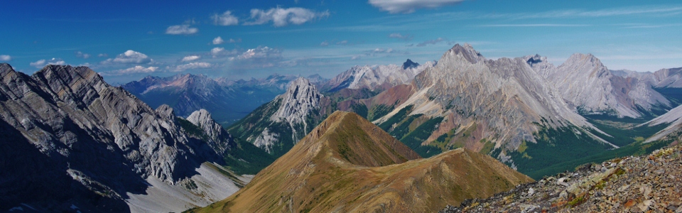
The view of the Opal Range from the top. From left to right: Gap Mountain, Elpoca Mountain and Tombstone Mountain behind. What’s that cloud building up?
.jpg)
Mount Tyrwhitt (right) rises up against “interesting” skies to the south.
.jpg)
Peaks of the Elk Valley beyond Grizzly Col. The Rock arch on Mount Tyrwhitt visible on the right.
.jpg)
Mount Rae dwarfing the competition (Mount Arethusa) across the Kananaskis highway.
.jpg)
I love the look of Arethusa. I shall have to climb her.
.jpg)
Aunty Di (right) and her best friend (my mom) enjoying the summit together.
.jpg)
Storm a brewin’ over Storm Mountain. Mist Mountain in the distant center also looking a little mistier than usual. Appropriate yet unfortunate given that we were still on the summit at this point.
.jpg)
Crap. The weather started going sideways in a hurry…
.jpg)
RUN!!! We knew that we had to get down quickly due to the deteriorating weather but thought that we would still have time to take a group summit shot. As we were lining everyone up for the photo, the ladies’ hair all stood straight up and I felt a distinct charge in the air before yelling at everyone to “get the hell down!” Here Brianne and my parents make an expedited descent as the rain starts to fall.
.jpg)
Safe at lower elevations and taking stock of what matters in my life. She looks so happy, doesn’t she?
.jpg)
Better late than never: group shot at slightly lower elevation than originally planned! Thanks again for the tickets Aunty Di!